
Population 5,407 Country Wales Dialling code 01348 | OS grid reference SM949376 Sovereign state United Kingdom | |
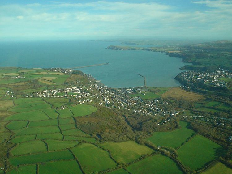 | ||
Fishguard and Goodwick is the name of a Community that wraps around Fishguard Bay, on the northern coast of Pembrokeshire, Wales. It comprises the two towns of Fishguard and Goodwick, with their neighbourhoods of Dyffryn, Harbour Village, Penyraber, Lower Town, and Stop-and-Call. Within the community are two railway stations and Goodwick Ferry Terminal, which is the terminus of the A40 London to Fishguard Trunk Road.
Contents
- Map of Fishguard and Goodwick UK
- Governance
- Topography
- Protected sites
- Geology SSSI
- National Park
- Scheduled Monuments
- Listed buildings
- Conservation Areas
- References
Map of Fishguard and Goodwick, UK
Governance
The Community has a council called Fishguard and Goodwick Town Council. Three wards elect a total of 14 council members: Goodwick (6), Fishguard North West (4) and Fishguard North East (4).
Topography
The three wards take in three areas of habitation, each fronting onto a section Fishguard Bay, a sheltered bay on the north coast of Pembrokeshire, South Wales. The coastline of the bay is entirely within the community boundary. Much of the shoreline has substantial cliffs although the section between the two towns, known as the Parrog, has a wide beach and leads to an area of flat marshland, and the River Gwaun at Lower Town harbour flows from the wooded valley of Cwm Gwaun.
Goodwick ward includes the town of Goodwick on the north-east corner of the bay and Harbour Village alongside the ferry terminal. The north-west side of the bay is dominated by the major Ferry terminal at which the railway and the A40 terminate and from which two ships a day sail to Rosslare Europort, Ireland. Inland from Goodwick are the two settlements of Stop-and Call and Dyfryn. Within the bay itself are two 1 km long breakwaters ensuring safe port moorings, and between the ferry terminal and the outer breakwater is the Fishguard Lifeboat Station. North of the outer breakwater the community boundary takes in the east coast of Strumble Head including the rocky headland of Pen Anglas. The Parrog is a stretch of sea-front and beach facing Fishguard bay, including the 'Ocean Lab' visitor centre, Projecting north-east from the Parrog is the inner breakwater, whilst on the inland side is Goodwick Moor Nature Reserve, 15.6 hectares (39 acres) of reed-bed and mire, home to otters and water voles, and managed by the Wildlife Trust of South and West Wales.
Fishguard North West ward has no coastline, occupying the western part of the town of Fishguard south of the A487 and west of Wallis Street. The area includes the south-western half of the historic centre of Fishguard upper town, with significant areas of housing and the Ysgol Bro Gwaun senior school, for which major rebuilding plans were announced at the end of 2015.
Fishguard North East ward includes the other half of the historic upper town core, and an area of 20th century housing known as Penyraber, beside the cliffs of Saddle Point. It also includes the steep slopes of the Lower Town area and the quayside of the picturesque old harbour. The harbour and Lower Town were the location used by Richard Burton and Elizabeth Taylor for the 1972 film of Dylan Thomas's Under Milk Wood. The ward also includes the headland east of the town, where the A487 Fishguard to Bangor Trunk Road runs north east out of Fishguard with sharp bends and steep gradients as it climbs up to the cliff top near Castle Point.
Protected sites
Within Fishguard and Goodwick community there are a wide variety of protected sites from rocky cliffs and ancient monuments to listed buildings and three conservation areas.
Geology SSSI
The cliffs either side of Fishguard Lower Town harbour are an SSSI notable for its geology. From Saddle Point on the western side, round to Castle Point on the eastern headland, the geology has legal protection because of its notable Ordovician Pillow Larva, in which the Llanvirn series is well demonstrated. Many of the rocks of Pembrokeshire have their origins some 460 million years ago in vast volcanic outpourings of ash and Tuff, and more rarely flows of larva, which, as here, cooled into a number of pillow formations.
National Park
Although the Pembrokeshire Coast National Park includes almost all of the coastline, it has three gaps, of which one is Fishguard and Goodwick. Most of the Community is excluded from National Park jurisdiction. Several lengths of the Community boundary are also the boundary to the National Park, both to east and west. Only two small areas of the Community are within the National Park, these being: the Castle point headland north of the A487 to the east; and the northwest end of the community along the Pen Anglas headland of Strumble Head. For these areas the Park is the legal Planning Authority, unlike the rest of the Community, for which Pembrokeshire County Council has that responsibility.
Scheduled Monuments
There are three scheduled monuments in the community. Two chambered tomb sites are prehistoric, and the Old Castle is a post-medieval site:-
Listed buildings
Two buildings within the community are listed grade II*.
There are also 161 grade II listed buildings across the two towns, including shops, houses, Churches, inns and public buildings. The largest density of these is in Fishguard town centre, which has 112, particularly along the Market Square and Main Street, Hill Terrace, Tower Hill and Hamilton Street, with another heavy cluster along High Street and West Street. It includes several terraces on Park Street and Nottipass Street. The Lime kilns on The Slade and farm buildings at Maesgwynne are also listed. In Fishguard Lower Town there are a further 35 grade II buildings, mostly harbour-side cottages, clustered around Quay Street, Bridge Street, Newport Road and Glyn-y-mel Road. In Goodwick there are 14 listed buildings, particularly in the centre, including the Lifeboat memorial, Institute, two churches and several houses and cottages.
Conservation Areas
This community has 3 of Pembrokeshire's 24 Conservation areas. These afford a wide-area protection for the special character of an area, regulating the building construction and alterations within the protected area and influencing the landscaping of outdoor spaces. The three areas match closely to the three historic settlement cores, and to the clusterings of the listed buildings. All three conservation areas were first drawn up in 1976, had a revision in 1992 and an appraisal in 2016.
Lower Town Fishguard Conservation Area: Lower Town is thought to be oldest of the three settlements, growing up around the old harbour. The 2016 conservation area appraisal affirms the maritime history and coastal landscape as key significant features, and the resulting narrow streets, quayside buildings, constrained building plots and separation from the rest of Fishguard give it picturesque value that the conservation area management plan seeks to protect and enhance. The conservation area is 19.23 hectares (47.5 acres) and covers the quay and hillside to the north, along the Gwaun valley, and adjoins the Fishguard Conservation Area where the main road climbs up from lower to upper town
Fishguard Conservation Area (upper town): The special characteristics identified in the 2016 appraisal included the dramatic coastal setting, the mix of buildings from the 17th, 18th and 19th centuries, the market place with radial streets, historic shop fronts, narrow streets and alleyways and the extreme topography separating the upper and lower towns. The town had a medieval origin and Norman castle, but its prosperity increased as fishing and coastal trade increased through the 17th and 18th centuries. The sheltered harbour served both trading vessels and those travelling to Ireland, and allowed ancillary industries such as boat-building and rope-making to thrive, and the townscape retains many elements from that period of prosperity. 18.35 hectares (45.3 acres) of the historic core of the town and the former industrial area of The Slade, leading down to the shoreline, are included in the conservation area.
Goodwick Conservation Area: Goodwick as a settlement saw its period of growth into a town later than Fishguard. Although a maritime history and coastal setting are noted as significant in defining it's special character, it is the period of late 19th and early 20th century growth that defines the town's character. With the 1906 arrival of the railway, and the use of Goodwick Harbour for trans-Atlantic liners, Goodwick had a fashionable heyday in the Edwardian period, and the Victorian and Edwardian shops are identified as being key parts of Goodwick's character. The Conservation Area covers 29.53 hectares (73.0 acres) including the town centre and the residential streets on the hillside northwest of the railway and ferry terminal.