
 | ||
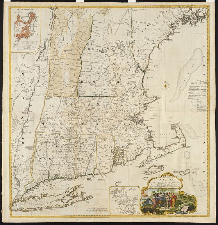
The Equivalent Lands were several large tracts of land that the Province of Massachusetts Bay made available to settlers from the Connecticut Colony after April 1716. This was done as compensation for an "equivalent" area of Connecticut-claimed territory which had been inadvertently settled by citizens of Massachusetts. The problem had arisen due to errors and imprecise surveys made earlier in the seventeenth century. The Equivalent Lands were never mapped.
Contents
Background
The area from which the Equivalent Lands were created belonged to the Abenaki people prior to colonial settlement.
The border between Massachusetts and Connecticut was first surveyed by the Massachusetts Bay Colony in 1642, following Springfield, Massachusetts' 1641 alliance with Boston. (Springfield left the fledgling Connecticut Colony during the late 1630s, following several disagreements with settlers from Hartford.) For the next 72 years, the Massachusetts Bay Colony controlled lands as far south as Warehouse Point at Windsor Locks—the northernmost point on the Connecticut River controlled by the tides. In the 1690s, Connecticut Colony officials performed their own survey, discovering errors that were made in Massachusetts's 1642 survey.
Finally, the boundaries between Massachusetts and Connecticut were cooperatively surveyed, beginning in 1713. At that time, it was found that of the large seventeenth century land grants that had been made available to Springfielders by the Massachusetts Bay Company, 107,793 acres (436.22 km2) actually belonged to the Province of Connecticut. The affected settlers had established themselves in and about the towns of Springfield, Westfield, Suffield, and other areas west of the Connecticut River, believing themselves to be in lands belonging to the Massachusetts Bay Company. Because a change of jurisdiction was unappealing to an overwhelming number of those already inhabiting the area, it was popularly agreed that Massachusetts would retain administration over the settled lands, and in return, a grant of property ownership should be made to Connecticut of an equal number of acres, "as an equivalent to the said colony."
Creation and further development
The surveys laying out the new tracts were concluded on November 10, 1715. One tract was in the area around Pelham and Hadley, Massachusetts; another in the area encompassing modern-day Putney, Brattleboro and Dummerston, Vermont; and another along the east side of the Connecticut River.
The commissioners appointed to locate these lands were Joseph Dudley, governor of Massachusetts; Gurdon Saltonstall, governor of Connecticut; Elisha Hutchinson and Isaac Addington of Massachusetts; and William Pitkin and William Whiting of Connecticut. The Equivalent Lands were then made available for purchase at Hartford on 24 and 25 April 1716, with the proceeds from the sale going to the founding of Yale College. The lands were grouped in at least three parcels; however, no maps are extant of the Equivalent Lands–there may have been additional areas.
A group of four speculators purchasing a 44,000-acre (180 km2) parcel included a Bostonian, William Brattle, Jr. (for whom Brattleboro, today located in the state of Vermont, was named). Other initial purchasers of the lands included Paul Dudley, Thomas Fitch III, and Jonathan Belcher.
Founding of Brattleboro
To defend the Province of Massachusetts Bay against Chief Gray Lock and others during Dummer's War, the Massachusetts General Court voted on December 27, 1723, to build a blockhouse and stockade north of its Northfield settlement in this parcel. Lieutenant-governor William Dummer signed the measure, and construction of Fort Dummer began on February 3, 1724. It was completed before summer. On October 11 of that year, the French attacked the fort and killed some soldiers. In 1725, Dummer's War ended. In 1728 the fort was converted into a trading post for commerce with friendly Indians. But in 1744, King George's War broke out, lasting until 1748. A small body of troops remained at the fort until 1750, after which it was considered unnecessary. The settlement surrounding the fort, "Brattleborough", was only scarcely populated until after the 1763 Treaty of Paris, when France finally abandoned the new world.
Outcomes
Surveyor Richard Hazzen was sent to survey the area again in the winter of 1740–1741 in the determination of the New Hampshire Grants–Massachusetts Colony boundary line.
In 1752, a large section of the grant fell under the dominion of the new Province of New Hampshire, in a section now belonging to Vermont. The area making up the rest of the Equivalent Lands eventually fell under the control of other colonial entities based, in part, on the original royal charters. After many boundary permutations, the Equivalent Lands are now part of present-day Vermont, New Hampshire, Connecticut and Massachusetts.