
- average 471 cu ft/s (13 m/s) Discharge 13.34 m³/s Basin area 1,207 km² | - min 58 cu ft/s (2 m/s) Length 92 km Basin area 1,207 km² Country United States of America | |
 | ||
- max 4,810 cu ft/s (136 m/s) Sources | ||
The Entiat River is a tributary of the Columbia River, joining the Columbia near Entiat. The USGS lists two variant names for the Entiat River: En-ti-at-kwa River and Entiatqua River. The river's name is derived from the Columbia-Moses (Salishan) term /nt'yátkw/ [nt'iátkw], meaning "place of grassy water". The name, spelled "Entiat", was selected for the river in 1958 by the Chelan County Public Utility District.
Contents
Map of Entiat River, Washington, USA
The Entiat River is located entirely within Chelan County, in Washington state in the United States. Over 90% of the drainage basin of the Entiat River and its tributaries is publicly owned property, mostly the Wenatchee National Forest. A large number of place names in the Entiat River basin were given by Albert H. Sylvester.
CourseEdit
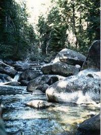
The Entiat River's headwaters lie in the Glacier Peak Wilderness of the Wenatchee National Forest. Its main source comes from the slopes of Mount Maude and Seven Fingered Jack, and Entiat Glacier. From there the river flows east through Entiat Meadows before turning south. It flows south and southeast between the Entiat Mountains on the west and the Chelan Mountains on the east.
Downstream from the main river's confluence with the North Fork Entiat River, the Entiat River falls over Entiat Falls. It collects the waters of many small tributary creeks, including the Mad River.
In its final miles, the Entiat River turns east to join the Columbia River at Columbia river mile 483.7, just south of the small city of Entiat. At this point the Columbia River is a reservoir created by Rocky Reach Dam. The reservoir's name is Lake Entiat. Fern Lake is located at the headwaters of the North Fork Entiat. Entiat Glacier, located in a cirque on the eastern side of Mount Maude and Seven Fingered Jack, is the headwaters of the Entiat river.
Flora and faunaEdit
The Entiat River supports populations of Chinook salmon, steelhead trout, and bull trout. The populations are relatively small due to the scarcity of juvenile-rearing habitat in the lower Entiat River.