
 | ||
Restaurants Against the Grain Urban Ta, Town & Country Buffet, Waterside Bistro, Tim Hortons, La Prep | ||
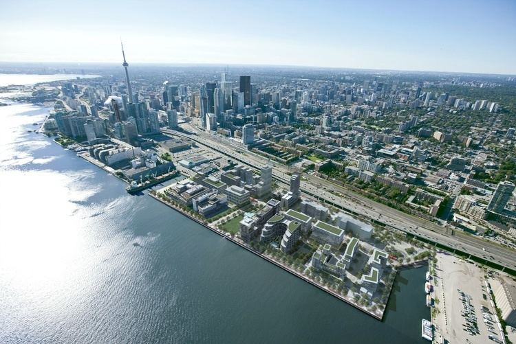
Waterfront toronto unveils first private sector development in east bayfront
East Bayfront, or the East Bayfront Precinct, is an emerging neighbourhood in Toronto, Ontario, Canada. It is currently undergoing a transformation from industrial use to mixed-use as part of Waterfront Toronto's plans to create a residential and commercial district urban core near the lake.
Contents
- Waterfront toronto unveils first private sector development in east bayfront
- Map of East Bayfront Toronto ON Canada
- Toronto s revitalized waterfront from east bayfront to the port lands
- Changing land use
- List of Quays and Slips
- Transportation
- References
Map of East Bayfront, Toronto, ON, Canada
The area is bordered by the Parliament Street to the east, Jarvis Street and the Jarvis Slip to the west, and the rail line and Gardiner Expressway to the north.
The area is 15.5 hectares (38 acres) of land. The area was filled in during the 19th and 20th Century to accommodate growth of business needing access to the waterfront.
Toronto s revitalized waterfront from east bayfront to the port lands
Changing land use
The area is undergoing a transformation and will host a number of different tenants:
Existing
A number of small industrial-commercial business parks dots the area, but some are being demolished and replaced with parking lots. There are four privately owned public parking lots in the district.
New
The district is mostly concrete with very few trees or greenspace. The Water's Edge Promenade will provide tree line board walk to the area. Sugar Beach and the future Sherbourne Common will provide some green space. The area's revitalization is being managed by Waterfront Toronto, a partnership of Federal, Provincial and local governments encouraging progressive and sustainable development of the Toronto waterfront.
The area includes a 130,000-square-metre (1,400,000 sq ft) office and institutional zone on the dockside tract of East Bayfront. This section consists of the 42,000-square-metre (450,000 sq ft) Corus Quay and the George Brown College's Health Sciences Campus.
In December 2009, Waterfront Toronto revealed the first major private sector development for the district, called Parkside. The $200 million residential development project, designed by Moshe Safdie and developed by Great Gulf Group of Companies, will be located on the northeast corner of Queen's Quay East and Sherbourne, south of the Gardiner Expressway and just east of the new Sherbourne Park.
List of Quays and Slips
Most of the remaining slips are not in use due departure of a number of business along the water's edge:
Transportation
The Bayfront area is accessed by various roads and expressways:
There are a number of local routes in the area cut off by either Lake Ontario or the Gardiner:
Most of these local routes exists to service local businesses and customers.
Future plans by the TTC would see streetcar service in the district. Streetcars would run from Union Station down to Bay and Queen's Quay, head east along the Queens Quay (southside) to Parliament Street. The interim terminus at Parliament will feature a loop, but the TTC plans to extend the route into the East Donlands in the future.
The Toronto Transit Commission has two bus routes in the precinct's west end:
There is no public transit in the east end of the precinct. There are plans to develop a light rail line along Queens Quay, initially as far as Parliament Street.