
Native name Rio Doce Length 853 km | Basin area 83,400 km² Source elevation 500 m Mouth elevation 0 | |
 | ||
Brazil s doce river is full of dead fish
The Doce River (literally the "sweet river"; Portuguese: Rio Doce [ˈʁiu ˈdos(i)]) is a river in southeast Brazil with a length of 853 kilometres (530 mi). The river basin is economically important. In 2015 the collapse of a dam released highly contaminated water from mining into the river causing an ecological disaster.
Contents
- Brazil s doce river is full of dead fish
- Map of Doce River Brazil
- CourseEdit
- Economic valueEdit
- ClimateEdit
- Ecological disasterEdit
- References
Map of Doce River, Brazil
CourseEdit
The Doce River is formed by the junction of the Piranga and the Carmo near the historical city of Ouro Preto, whose sources are located in the foothills of the Mantiqueira and Espinhaço mountain chains at altitudes of about 1,200 m. It flows in a northeastern direction via Ipatinga, makes a wide curve near Governador Valadares, and flows in a southeastern direction passing through Conselheiro Pena, to enter the Atlantic Ocean near Linhares in Espírito Santo state. Its main tributaries are the Piracicaba, Casca, Matipó, Caratinga-Cuieté, Manhuaçu, Santo Antônio and Suaçuí Grande, in Minas Gerais; the Pancas, Guandu, and São José, in Espírito Santo.
Part of the river basin is contained in the 3,562 hectares (8,800 acres) Augusto Ruschi Biological Reserve, a fully protected area. South of the point where the Piracicaba enters the river near Ipatinga the river forms the eastern boundary of the Rio Doce State Park.
Economic valueEdit
The Doce river has great economic importance for the region. The basin is home to the largest steel making complex in Latin America. Three of the five largest companies in Minas Gerais state in the year 2000, Companhia Siderúrgica Belgo Mineira, Arcelor Mittal (Acesita) and Usiminas, are located there. The largest open-pit mine in the world is operated in the basin by the Companhia Vale do Rio Doce. These industrial conglomerates have an important role in Brazilian exports of iron ore, steel, and cellulose (Cenibra). In addition, the Doce basin contributes greatly to production of coffee from Minas Gerais and Espírito Santo as well as fruit pulp from Espírito Santo.
Fifteen percent of the GDP of the state of Minas Gerais is produced in the region with the municipality of Ipatinga accounting for 5.4% of that total. Ipatinga is the major city of the Vale do Aço Metropolitan Area.
The economy of the basin is based on the following activities:
- agriculture: dairy and beef cattle, pig raising, coffee, sugar cane, fruits and vegetables and cocoa;
- industry: siderurgy, metallurgy, mechanical, chemical, food, alcohol, textile, leather, paper and paper pulp; and
- mining: iron, gold, bauxite, manganese, and precious stones.
According to the Anuário Estatístico do Brasil (IBGE) the Doce basin has a population of about 3,100,000, with the urban population making up 68.7% of the total population. In recent years the population has declined, with small towns and rural areas losing up to 40% of their population.
Major cities located along the Doce or in its basin are: Timóteo, Coronel Fabriciano, Ipatinga, Governador Valadares, Colatina, and Linhares.
ClimateEdit
According to the Koppen classification, there are three climatic types in the Doce basin:
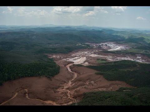
Ecological disasterEdit
On 5 November 2015, a mine dam holding back waste water from an iron ore mine in Mariana, South-Eastern Brazil, owned by BHP Billiton and Vale collapsed, devastating a nearby town with mudslides, killing at least 17 people, injuring more than 50 and causing an enormous ecological damage, and threatening life along the Rio Doce and the Atlantic sea near the mouth of the Rio Doce.