
Country Brazil State Espírito Santo Time zone UTC-3 (UTC-3) Area 1,423 km² Population 96,028 (2010) | Region Southeast Founded December 30, 1921 Demonym "colatinense" Elevation 71 m Local time Wednesday 11:29 AM | |
 | ||
Weather 33°C, Wind E at 10 km/h, 53% Humidity Colleges and Universities University Centre of Espirito Santo, Castelo Branco Faculty Team Associação Atlética Colatina | ||
Baile do comandante colatina after movie
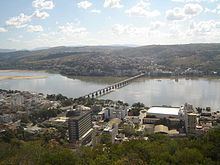
Colatina is the second largest city in the north of Espírito Santo, Brazil, 127 km north of the capital Vitória and on the trainline from Vitória to Minas Gerais. It lies on the banks of the Doce river, through which as much as 700 cubic meters of water per second may flow. Its population was 120,677 (2013) and its area is 1,423 km².
Contents
- Baile do comandante colatina after movie
- Map of Colatina State of EspC3ADrito Santo Brazil
- Viajando todo o brasil colatina es
- History
- References
Map of Colatina, State of Esp%C3%ADrito Santo, Brazil
Viajando todo o brasil colatina es
History
The first attempts to colonize the area where Colatina now lies were in 1857. 46 people established themselves in the area, which was easy at first, as land had already been assigned to each family. This proved unsustainable, though, when the Indians attacked the colony and massacred quite a number of people. In 3 years, all of the colonists had left the area, and it would be another 30 years before major influx would start up again. Until then, small advances were made along small river tributaries, which went on until 1925. Only after 1928, after the completion of the bridge over the Doce river, did more stable and sustained growth come to the region.