
Population (2010 Census) 1,693 inhabitants Local time Thursday 10:01 AM | Time zone USZ1 (UTC+02:00) | |
 | ||
Founded 1510 (earliest surviving record) Weather 2°C, Wind E at 8 km/h, 87% Humidity | ||
Dobrovolsk (Russian: Добровольск ; German: Pillkallen or Schloßberg ; Lithuanian: Pilkalnis ; Polish: Pilkały ) is a village in Russia.
Contents
- Map of Dobrovolsk Kaliningradskaya Oblast Russia 238743
- Demography
- Location
- History
- Memorials and Cemeteries
- Culinary specialities
- Sons and daughters of the town
- References
Map of Dobrovolsk, Kaliningradskaya Oblast, Russia, 238743
It is the former administrative center of what has become the Krasnoznamensky District of Kaliningrad Oblast, Russia. It therefore was politically in Prussia after 1701 until the unification of Germany, and part of Germany from 1871 till 1945.
Demography
Population:
Where religion is recorded from the census process, pre-1945 census data show the religious affiliation of the population as overwhelmingly Prussian evangelical. However, 34 people were recorded as being Jewish and 8 of the inhabitants were recorded as being Roman Catholic in 1890.
Location
Dobrovolsk is located approximately 12 km (8 miles) to the north of Nesterov and 15 km (9 miles) south of the regional capital of Krasnoznamensk. It is approximately 25 km (16 miles) to the south of the frontier with Lithuania which between 1945 and 1990 was an internal frontier within the Soviet Union but has subsequently reverted to the status of an international frontier. Kaliningrad itself is approximately 150 km (92 miles) to the west on the far side of the Kaliningrad enclave.
History
The earliest surviving German-language record of the place dates from 1516 under the name " Schlosbergk “. Slightly later the name Mühlenberg is also used. Russian sources give the date of the earliest record as 1510. Nevertheless, it is believed that there was already a trading settlement in existence before this. The name “Pillkallen” first appears in the records in 1545 in connection with an inheritance dispute, and this name for the town is thought to have originated with Lithuanian settlers. (Lithuanian pilkalnis: hill / mound / castle mound). In 1549 a wooden church was built in the developing market town and a school was established in 1550.
Between 1709 and 1711 the population was devastated by plague, but this was followed by a wave of protestant settlers from Nassau. The king granted Pillkallen along with nearby Gumbinnen town privileges in 1725. A stone church was built in 1756 using locally occurring field stones. Pillkallen/Schloßberg became an administrative sub-centre under Gumbinnen There followed two centuries of moderate prosperity during which Pillkallen became known for local agricultural fairs and for the quality of local agricultural produce, including cheeses and the local Pillkanis beer. 1892 saw the opening of a rail connection to Stallupönen (now Nesterov) followed in 1901 by a narrow gauge railway to Lasdehnen (now Krasnoznamensk)
With the outbreak of war in 1914 Pillkallen was attacked by Russian troops under Lt. Gen. Khan of Nakhichevan in August 1914 and again between October 1914 and January 1915, which led to the town being almost entirely destroyed, but after the end of the war in 1918 it was rebuilt with help from Breslau which was then in Germany and Pillkallen’s partner town. Between 1933 and 1934 a hospital able to accommodate 130 patients was opened as well as a sports stadium and a municipal swimming pool.
With nationalism still in the ascendancy across most of Europe during the twentieth century, the German Nazi government Germanized the Old Prussian (i.e. non-German) name of Pillkallen to "Schloßberg" in 1938.
During 1944 the area was assigned to the forces of Russia’s 3rd Belorussian Front and the closing months of the war the town found itself at the centre of savage fighting between the Soviet and German armies, changing hands four times. Schloßberg was again destroyed. All that was left of the eighteenth century church was its stone font. 15 January 1945 marked Schloßberg’s capture by the Red Army.
In 1947 Schloßberg was renamed "Dobrovolsk", at the same time losing its municipal status. The functions of a regional capital were transferred to Krasnoznamensk which had been less fought over during the war, and Dobrovolsk was formally designated a village (Добровольский сельский Совет). The municipal status was modified in 1990 to "rural district" (Добровольский сельский округ). At the end of the twentieth century the former town and its immediate surroundings remained in large part destroyed.
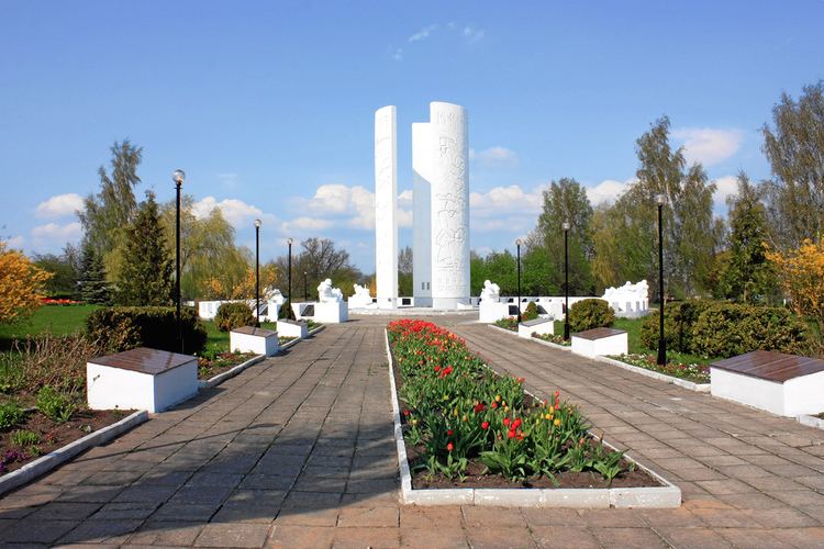
Memorials and Cemeteries
Although much of the town remains destroyed, it is nevertheless home to memorials and cemeteries reflecting the fighting of recent centuries. An obelisk commemorates Prussian soldiers killed in the Franco-Prussian War of 1870-71 and there is a First World War cemetery containing the graves of Germans and Russian soldiers. There is also a Soviet Memorial Complex commemorating the fallen of the Second World War, of whom approximately 5,300 are buried here.