
Length 105 km (65 miles) Date completed 1784 Construction began 1775 | Status Open Locks 20 | |
 | ||
End point Pripyat River nearSapotskin, Belarus | ||
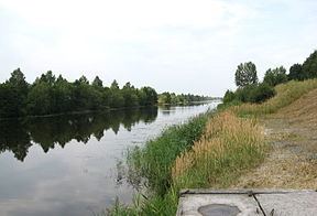
Dnieper–Bug Canal (alternately spelled Dnepr-Bug Canal), or the Dneprovsko-Bugsky Canal is the longest inland ship canal in Belarus that connects the Mukhavets River, a tributary of the Bug River, and the Pina River, a tributary of the Pripyat River.
Contents
- Map of DniaproC5ADska Buhski kanal Belarus
- Origins
- Proposal and design
- Construction and operation
- Decline and abandonment
- Reconstruction
- Decline and renewal
- References
Map of Dniapro%C5%ADska-Buhski kanal, Belarus
Originally the canal was named the Royal Canal (Polish: Kanał Królewski), after the King of Poland Stanisław August Poniatowski, since he was the initiator of the project. It is an important part of the transportation artery linking the Baltic Sea and the Black Sea. The total length of the canal system from Brest to Pinsk is 196 km (122 mi), including the artificial waterway 105 km (65 mi) long. The canal system comprises the western slope from Brest to Kobrin, a 64 km (40 mi) stretch of the Mukhavets River with regulated water level, a 58 km (36 mi) summit pound, the eastern slope, 47 km (29 mi) stretch of the canal, a 27 km (17 mi) stretch of the Pina River with regulated water level. The drainage area of the canal system totals 8.5 thousand km² (3.3 thousand mi²).
Origins
Canal building flourished in the Polish-Lithuanian Commonwealth in the late 18th century. Yet many of the early canals are no longer in active service, having been superseded by railroads and highways. The Dnieper–Bug Canal after several enlargements is still providing a convenient inland waterway. Till the 18th century there was a portage between Kobrin and Pinsk as it was a part of the important long-distance trade route from the Black Sea to the Baltic Sea. The names of the Voloka River and the village of Mukhovloki near Kobrin remind of the ancient portage. People settled along the portage route since ancient times (Trade route from the Varangians to the Greeks).
Proposal and design
In the mid-17th century, Jerzy Ossoliński, Crown Court Treasurer of the Polish-Lithuanian Commonwealth was the first to suggest the idea of upgrading the portage to a canal with locks. Yet the work started only 120 years later. In 1770, the canal was planned by the prominent cartographer Franciszek Florian Czaki.
Construction and operation
It was built in 1775-1784 during the reign of Stanisław August Poniatowski, the last king of the Polish-Lithuanian Commonwealth. Originally it was named Kanał Królewski (English: Royal Canal), after the Polish king, since he was the initiator of the project. Additional work was carried out starting in 1837 by Russian Empire and completed around 1846-1848. To supply the canal system with water, mainly the canal pound, Beloozerski and Orekhovski watercourses were started in 1839 and completed in 1843.The number of movable weirs between Brest and Pinsk reached 22. As a result, the canal became navigable for bigger vessels, steamers at any time from spring till autumn. In 1847, the Kanał Królewski was renamed into the Dneprovo-Bugski Canal.
Decline and abandonment
After the construction of the railway along the canal in the late 19th century the canal was used mostly for rafting lumber, exported to western countries. During World War 1 the canal was not in use.
Reconstruction
During the 1920s it was partly rebuilt anew for the Riverine Flotilla of the Polish Navy (Polish: Flotylla Rzeczna Marynarki Wojennej), better known as the Pinsk Flotilla. The Flotilla was the inland branch of the Polish Navy operating in the area of the Pinsk Marshes between the Polish-Bolshevik War and World War II. During the 1920s 2 locks were built.
In 1940, the Soviet authorities initiated a large-scale reconstruction of the canal. A 23 km (14 mi) long stretch of the canal was built near Kobrin to straighten the old canal. 8 locks were built replacing movable weirs.
Navigation on the Dnieper–Bug Canal is interrupted by weirs on the rivers Mukhavets and Bug near Brest, Belarus, the border town. That is the only place that makes impossible, for the time being, the navigation from Western Europe to Belarus and Ukraine through inland waterways. The waterways from the German-Polish border (Oder River, through the Warta, Brda and Noteć rivers, Bydgoszcz Canal, Vistula River, Narew River, Bug River) once used to link the Belarus and Ukrainian inland waterways via Mukhavets River, Dnieper–Bug Canal, Pripyat River and Dnieper River), thus connecting north-western Europe with the Black Sea.
Decline and renewal
Recently the dam in the Bug, making it impossible for ships to pass, has led to a considerable neglect of the most western part of the Mukhavets; some of the locks have been filled in and Brest Harbor can only be reached by vessels approaching from the east.
More recently efforts have been undertaken to restore the canal to a class IV inland waterway of international importance. In 2003 the Government of the Republic of Belarus adopted the inland water transport and sea transport development program to rebuild the Dnieper–Bug Canal shipping locks to meet the standards of a class Va European waterway. According to the Belarus government (see report below), four sluice dams and one shipping lock have been rebuilt which allow for the passage of vessels 110 meters (361 ft) long, 12 meters (39 ft) wide with a draught of 2.2 meters (7 ft). It is expected that reconstruction will continue over the next few years.