
Topo map USGS Basque Summit Mountains Desatoya Peak | Elevation 3,041 m | |
 | ||
Similar Granite Peak, Arc Dome, Star Peak, Ruby Dome, Mount Grant | ||
Cold springs nevada part 5 journey into the desatoya mountains
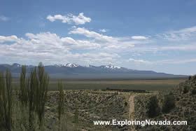
The Desatoya Mountains are located in central Nevada in the western United States, approximately 117 miles east of Reno by road. The range runs in a southwest-northeasterly direction along the border of Churchill and Lander counties, reaching a maximum elevation of 9,978 feet (3,041 m) (3041 m) at Desatoya Peak near Rock Creek Canyon.
Contents
- Cold springs nevada part 5 journey into the desatoya mountains
- Map of Desatoya Mountains Nevada USA
- GeographyEdit
- Trans mountain navigationEdit
- HistoryEdit
- The etymology of the name DesatoyaEdit
- References
Map of Desatoya Mountains, Nevada, USA
GeographyEdit
The range is separated from the Paradise Range in the south by Burnt Cabin Summit at the Nye County line, near the sites of Chalk Wells and Phonolite, and from the New Pass Range in the north by New Pass along U.S. Route 50. It is traversed by three routes:
Trans mountain navigationEdit
HistoryEdit
The Desatoya Mountains set the backdrop for both the Cold Springs and Smith Creek Pony Express stations; the Cold Springs Pony Express Station and the Pony Express National Historic Trail lie at the western edge of the range, whereas the Smith Creek Pony Express Station is situated at the eastern base on the edge of Smith Creek Valley.
The etymology of the name DesatoyaEdit
The precise morphology and etymology of the name Desatoya is unclear: whereas ...'toya' derives from the Shoshone word toyap (mountain), 'desa'... has been multifariously interpreted as 'short, low,' 'big-black,' and 'cold.'
Early documents record the range's name variously as the Lookout Range or the Sedaye Mountains, sedaye purportedly being an Indian word meaning 'no good.'