
Official name Davis Dam Opened 1951 | Opening date 1951 Length 490m Height 60 m Surface area 107.2 km² Turbine 5 | |
 | ||
Similar Parker Dam, Big Bend of the Colorado, Lake Mead National Recreatio, Imperial Dam, Edgewater Hotel and Casino | ||
Davis dam aerial view bullhead city arizona and laughlin nevada
Davis Dam is a dam on the Colorado River about 70 miles (110 km) downstream from Hoover Dam. It stretches across the border between Arizona and Nevada. Originally called Bullhead Dam, Davis Dam was renamed after Arthur Powell Davis, who was the director of the U.S. Bureau of Reclamation from 1914 to 1923. The United States Bureau of Reclamation owns and operates the dam, which was completed in 1951.
Contents
- Davis dam aerial view bullhead city arizona and laughlin nevada
- Map of Davis Dam Bullhead City AZ 86429 USA
- Davis dam on colorado river
- DescriptionEdit
- References
Map of Davis Dam, Bullhead City, AZ 86429, USA
Davis Dam impounds the Colorado River and forms Lake Mohave.
Davis dam on colorado river
DescriptionEdit
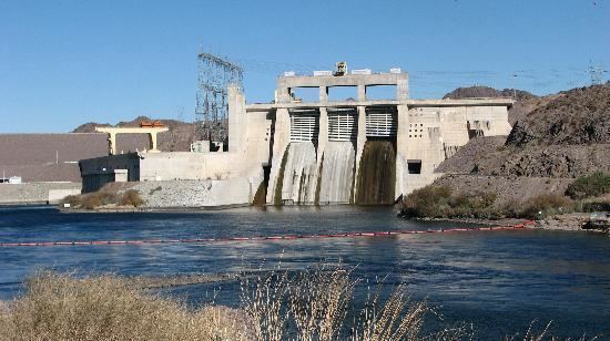
Davis Dam is a zoned earth-fill dam with a concrete spillway, 1,600 ft (490 m) in length at the crest, and 200 ft (61 m) high. The earth fill dam begins on the Nevada side, but it does not extend to the Arizona side on the east. Instead, there is an inlet formed by earth and concrete, that includes the spillway. The hydroelectric power plant is beside the inlet.
The dam's purpose is to re-regulate releases from Hoover Dam upstream, and facilitate the delivery of Colorado River water to Mexico. Bullhead City, Arizona, and Laughlin, Nevada, are located just below the dam along the river. Davis Camp is also nearby. Bullhead City was originally a construction town for workers building the dam.
A road is located on the crest of the earth fill portion of the dam and a Forebay Bridge spans the Forebay. It was formerly part of Arizona State Route 68 to Nevada. In April 2004, the roadway was shut down to vehicle traffic. Pedestrian and bicycle traffic are permitted. The old roadway is now an extension of the Heritage Trail system. Barriers have been placed on the former road at each end of the earthen dam. The facility is heavily patrolled by security forces who strictly enforce parking regulations.
The Davis Dam Power Plant is a hydroelectric power plant located on the Arizona side of the dam, beside the inlet. The hydroelectric plant generates between 1 and 2 terawatt-hours of electricity annually. The plant has a capacity of 251 MW (337,000 hp) and the tops of its five Francis turbines are visible from outside the plant. The plant's head is 136 ft (41 m).