
Official name Imperial Diversion Dam Width (base) 76 ft (23 m) Opened 1938 | Opening date 1938 Length 3,475 ft (1,059 m) Height 26 m Surface area 23.29 km² Construction began 1936 | |
 | ||
Similar All‑American Canal, Laguna Diversion Dam, Parker Dam, Davis Dam, Palo Verde Dam | ||
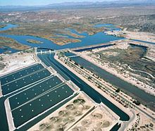
The Imperial Diversion Dam (National ID # CA10159) is a concrete slab and buttress, ogee weir structure across the California/Arizona border, 18 miles (29 km) northeast of Yuma. Completed in 1938, the dam retains the waters of the Colorado River into the Imperial Reservoir before desilting and diversion into the All-American Canal, the Gila River, and the Yuma Project aqueduct. Between 1932 and 1940, the Imperial Irrigation District (IID) relied on the Inter-California Canal and the Imperial Canal and Alamo River.
Contents
Map of Imperial Dam, Yuma, AZ 85365, USA
BackgroundEdit
The Imperial Dam was built with three sections; the gates of each section hold back the water to help divert the water towards the desilting plant. Three giant desilting basins and seventy-two 770 ft (230 m) scrapers hold and desilt the water; the removed silt is carried away by six sludge-pipes running under the Colorado River that dump the sediment into the California sluiceway, which returns the silt to the Colorado River. The water is now directed back towards one of the three sections which divert the water into one of the three channels. About 90% of the volume of the Colorado River is diverted into the canals at this location. Diversions can top 40,000 cubic feet (1,100 m3) per second, roughly the volume of the Susquehanna River and more than 50 times the flow of the Rio Grande.
The Gila River and the Yuma project aqueduct branch off towards Arizona while the All-American canal branches southwards for 37 miles (60 km) before reaching its headworks on the California border and bends west towards the Imperial Valley.