
Traversed by SH 12 Elevation 3,029 m | Topo map USGS Cucharas Pass | |
 | ||
Similar Cordova Pass, Spanish Peaks, West Spanish Peak, La Veta Pass, Rocky Mountains | ||
Highway of legends colorado route 12 trinidad to cucharas pass
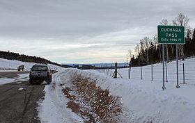
Cucharas Pass is a 9,938 ft (3,029 m) elevation mountain pass in the Sangre de Cristo Mountains in south central Colorado in the United States.
Contents
- Highway of legends colorado route 12 trinidad to cucharas pass
- Map of Cucharas Pass Colorado 81055 USA
- Highway of legends part 2 cucharas pass to walsenburg dashcam
- References
Map of Cucharas Pass, Colorado 81055, USA
At the top, the pass is signed as Cuchara Pass and the elevation on the sign there reads 9995 ft. State Highway 12 traverses the pass. Highway 12 is also signed as the Highway of Legends Scenic Byway, one of Colorado's Scenic and Historic Byways.
Highway of legends part 2 cucharas pass to walsenburg dashcam
References
Cucharas Pass Wikipedia(Text) CC BY-SA