
Country United States FIPS code 05-15490 Elevation 193 m Zip code 72626 Population 953 (2013) | Time zone Central (CST) (UTC-6) GNIS feature ID 0076681 Area 6.4 km² Local time Monday 9:53 PM Area code 870 | |
 | ||
Weather 21°C, Wind S at 19 km/h, 66% Humidity | ||
Trout fishing on the white river in cotter arkansas with hurst fishing service
Cotter is a city in Baxter County, Arkansas, United States. The population was 1,078 at the 2010 census.
Contents
- Trout fishing on the white river in cotter arkansas with hurst fishing service
- Map of Cotter AR USA
- His place resort cotter arkansas resort reviews
- History
- Exploration and settlement
- The Railroad
- The Bridge
- Geography
- List of highways
- Railroads
- Airports
- Demographics
- Education
- Notable people
- References
Map of Cotter, AR, USA
His place resort cotter arkansas resort reviews
History
Native American Bluff Dwellers were the original inhabitants of the area now known as Cotter. When Native Americans were moved westward on the Trail of Tears, Approximately 1000Cherokees crossed just a short distance upriver from the current location of Downtown Cotter.
Exploration and settlement
In 1819, Henry Schoolcraft was exploring the Ozarks and spent a night in the Cotter area. He said of the area,
White River is one of the most beautiful and enchanting streams, and by far the most transparent, which discharge their waters into the Mississippi ... We here behold the assembled tributaries flowing in a smooth, broad. deep, and majestic current ... skirted at a short distance by mountains of the most imposing grandeur.... [The] extreme limpidity and want of colour ... was early seized upon by the French traders on first visiting this stream, in calling it "La Rivière Blanche" (White River).
Future President, Herbert Hoover, spent the summer of 1892 helping Geologist John C. Branner survey the Northern Ozarks. By the early 1900s, there were many mining companies active in both Baxter, and Marion Counties. Cotter quickly became a central point where minerals could be shipped via Steamboat to much larger cities in Central Arkansas or Southern Missouri.
Originally, the river bend was known as either Lake's Ferry or Lake's Landing. At this spot, the White River turns sharply, making a convenient border for a town. The Spring that rises up from the caves beneath Cotter, also added to the appeal to early settlers. Lake's Ferry was known as one of the most beautiful spots on the river and was appreciated by locals and tourists.
The Railroad
Looking to capitalize on the growing trade in the area, the Missouri-Pacific Railroad announced plans to open the White River Line which would run through the area and would connect with the main line in Lake's Landing. By 1902, the Cotter post office had opened. 2 years later, the first school in Cotter opened. In 1905, the Missouri Pacific Railroad bought the area and sold over one thousand lots, mostly to railroad employees. The city was incorporated in 1905 as Cotter, Arkansas. By that time the population was over 600. The town was named after William Cotter, an official for the Missouri Pacific Railway System, which built a line through the small town. The materials required to build the town and railroad had to be brought in by Steamboats down the White River. Once the Railroad was completed, the use of Steamboats on the rivers of Arkansas decreased and eventually stopped altogether. In 1906, the first passenger train arrived, and the Tourist era began.
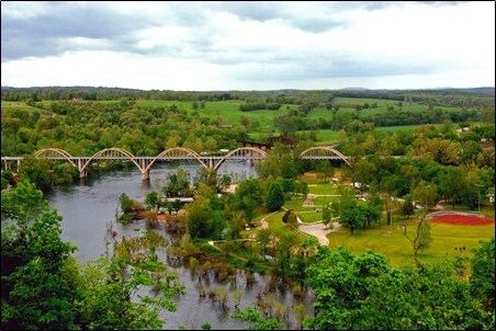
The Bridge
The mercurial White River caused many motorists problems, as the nearest crossing was over 100 miles (160 km) to the north in Branson, Missouri. An inconvenient ferry system made the need for a bridge apparent. Locals wanted a bridge, but they strongly opposed a toll bridge. Arkansas did not have a central highway body at the time, and was instead a patchwork of "road districts", which made the bridge-building efforts even more difficult. Without a toll, funding wasn't available until Arkansas Highway 12 was redesignated U.S. Route 62 in 1930. The Cotter Bridge was constructed through the area using a unique rainbow arch design.
Geography
Cotter is located at 36°16′29″N 92°31′42″W (36.274772, -92.528336).
According to the United States Census Bureau, the city has a total area of 2.5 square miles (6.5 km2), all of it land.
List of highways
Railroads
Mountain Home has one local railroad, the Missouri and Northern Arkansas Railroad. The MNA leases the track from Newport Arkansas to Kansas City Missouri, from the Union Pacific Railroad. The regular train traffic are empty coal trains from The Independence power plant, as well as a north and south local out of Cotter.
Airports
Cotter is accessible to two separate commercial airports, Ozark Regional Airport (Baxter County) and Flippin Municipal Airport (Marion County). There is also a rural air field, Valley Airport, located on Denton Ferry Road that serves small planes owned by residents.
Demographics
As of the census of 2010, there were 1,078 people, 472 households and 293 families residing in the city. The population density was 373.6 people per square mile (144.0/km²). There were 501 housing units at an average density of 203.2 per square mile (78.3/km²). The racial makeup of the city was 97.07% White, 0.87% Native American, 0.22% Asian, and 1.85% from two or more races. 1.52% of the population were Hispanic or Latino of any race.
There were 545 households out of which 20.8% had children under the age of 18 living with them, 48.5% were married couples living together, 8.6% had a female householder with no husband present, and 40.0% were non-families. 35.4% of all households were made up of individuals and 16.7% had someone living alone who was 65 years of age or older. The average household size was 2.08 and the average family size was 2.67.
In the city, the population was spread out with 19.7% under the age of 18, 8.7% from 18 to 24, 24.8% from 25 to 44, 26.7% from 45 to 64, and 20.2% who were 65 years of age or older. The median age was 43 years. For every 100 females there were 97.2 males. For every 100 females age 18 and over, there were 99.5 males.
The median income for a household in the city was $22,857, and the median income for a family was $34,375. Males had a median income of $26,298 versus $17,266 for females. The per capita income for the city was $15,893. About 11.9% of families and 16.8% of the population were below the poverty line, including 18.3% of those under age 18 and 13.3% of those age 65 or over.
Education
Public education is provided by the Cotter School District including Cotter High School (grades 7 through 12) and Amanda Gist Elementary School (kindergarten through grade 6).