
Country United States Elevation 223 ft (68 m) Area code(s) 870 Zip code 72112 Local time Sunday 5:35 AM | County Jackson Time zone Central (CST) (UTC-6) FIPS code 05-49580 Population 7,771 (2013) | |
 | ||
Weather 11°C, Wind W at 3 km/h, 89% Humidity University Arkansas State University-Newport | ||
Newport is a city in Jackson County, Arkansas, 84 miles (135 km) northeast of Little Rock, on the White River. The population was 7,879 at the 2010 census. The city is the county seat of Jackson County.
Contents
- Map of Newport AR 72112 USA
- Geography
- Climate
- Demographics
- Government and infrastructure
- Elementary and secondary education
- Postsecondary education
- Commerce
- Entertainment and literature
- Politics military and education
- Sports
- Folklore animals
- References
Map of Newport, AR 72112, USA
Newport is home to a campus of the Arkansas State University system, with particular focus on training in transportation careers. Newport is known as the town in which Sam Walton owned a Ben Franklin store prior to starting Wal-Mart.
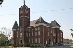
Newport has ten properties listed on the National Register of Historic Places.
Geography
According to the United States Census Bureau, the city has a total area of 13.7 square miles (35.5 km2), of which 13.4 square miles (34.8 km2) is land and 0.27 square miles (0.7 km2), or 1.92%, is water.
Climate
The climate in this area is characterized by hot, humid summers and generally mild to cool winters. According to the Köppen Climate Classification system, Newport has a humid subtropical climate, abbreviated "Cfa" on climate maps.
Demographics
As of the census of 2000, the city's residents comprised 7,811 people in 2,690 households 1,702 families. The population density was 599.2 people per square mile (231.5/km²). There were 3,118 housing units at an average density of 239.2 per square mile (92.4/km²). The racial makeup of the city was 56.57% White, 41.76% Black or African American, 0.27% Native American, 0.33% Asian, 0.01% Pacific Islander, 0.28% from other races, and 0.77% from two or more races. 1.13% of the population were Hispanic or Latino of any race.
There were 2,690 households out of which 26.2% had children under the age of 18 living with them, 42.5% were married couples living together, 17.5% had a female householder with no husband present, and 36.7% were non-families. 33.2% of all households were made up of individuals and 17.9% had someone living alone who was 65 years of age or older. The average household size was 2.29 and the average family size was 2.90.
19.6% of the population were under the age of 18, 16.7% from 18 to 24, 24.9% from 25 to 44, 20.9% from 45 to 64, and 17.9% 65 years of age or older. The median age was 37 years. For every 100 females there were 84.9 males. For every 100 females age 18 and over, there were 78.9 males.
The median income for a household in the city was $30,507, and the median income for a family was $41,426. About 23.6% of families and 28.1% of the population were below the poverty line, including 40.6% of those under age 18 and 17.5% of those age 65 or over.
Government and infrastructure
The Grimes Unit and the McPherson Unit, prisons of the Arkansas Department of Correction, are located in Newport, off Arkansas Highway 384, 4 miles (6 km) east of central Newport. The prison houses the state's death row for women.
The United States Postal Service operates the Newport Post Office.
Elementary and secondary education
Newport is supported with public education from the Newport School District, including Newport High School.
Postsecondary education
The main campus of the two-year community college, Arkansas State University-Newport is located here.