
Existed: 1932 – present Constructed 1932 | Length 32.27 km | |
 | ||
Counties Hartford County, Connecticut, Litchfield County, Connecticut | ||
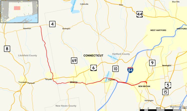
Route 72 is a state highway in the western part of the Greater Hartford area. Route 72 is an L-shaped route with a north–south section in Plymouth and Harwinton and an east–west section from Bristol to New Britain. Route 72 is a freeway from Route 9 in New Britain to Route 177 in Plainville. It is signed as an east-west route.
Contents
Map of CT-72, Harwinton, CT 06791, USA
The plan to extend the highway through the Forestville section of Bristol as a four-lane boulevard is complete. The construction project broke ground on October 15, 2007 and was completed in the spring of 2011. The contractor for the project was Manafort Brothers, based out of Plainville. The new section of route 72 opened on September 27th, 2010.
Route description
Route 72 begins as a four-lane freeway at Route 9 in New Britain, expanding to six lanes after the junction with Route 71 at Exit 9. Route 72 overlaps with I-84 as it crosses from New Britain into the town of Plainville. In Plainville, Route 72 has an exit to and from Route 372, an eastbound on-ramp from Route 10 via Route 372 and SR 511, and an eastbound offramp to Woodford Ave (SR 536). After crossing the Pequabuck River, it has a partial interchange with Route 177 before the freeway ends at Forestville Avenue and the western terminus of Route 372. Route 72 continues, crossing Forestville Avenue as a four-lane median separated boulevard to the Bristol town line. Within Bristol, Route 72 runs 5.5 miles (8.9 km) along several streets. It continues on the four-lane median separated boulevard (known as E Bartlett Barnes Highway) to Pine Street, where it becomes four lanes undivided, and follows Pine Street to Riverside Avenue and crosses the Pequabuck River before intersecting with Route 229. Route 72 continues on Riverside Avenue, Main Street, School Street (intersecting Route 69), Divinity Street, Park Street, and Terryville Road. The route runs parallel to the Peqaubuck River in Bristol and crosses it several times. Route 72 then enters the town of Plymouth, where the road turns north to follow South Riverside Avenue, North Riverside Avenue, and Poland Brook Road. Route 72 intersects with US 6 in the Terryville section of town, then continues north in the rural town of Harwinton where it goes along Terryville Road, eventually ending at Route 4. Route 72 is 20.10 miles (32.35 km) long.
The section of Route 72 from Route 9 to Route 372 (Corbin Avenue) in New Britain is also known as the Thaddeus Kosciuszko Highway. The section from Route 372 (Corbin Avenue) in New Britain to the freeway end at the Plainville-Bristol town line is also known as the Polish Legion of American Veterans Memorial Highway. The section in Bristol from the Plainville town line to Pine Street is also known as the E Bartlett Barnes Highway.
History
Route 72 was established in the 1932 state highway renumbering between Route 66 (then Route 14) in Middletown to Route 10 in Plainville. Since then, the route has been extended west and north and relocated to an expressway. The original route has been transferred to Routes 3 and 372.
In 1942, a portion of US 6 in Bristol and Plymouth was transferred to Route 72 after a realignment of US 6 to use former US 6A. Another section of Route 72 was realigned in Berlin the same year with the construction of an interchange with the Berlin Turnpike. In 1954, the former Routes 117 (Bristol to Torrington) and 49 (Torrington to Norfolk) were transferred to Route 72, extending the route through Torrington to the Massachusetts state line.
In 1962, the section of Route 72 north of modern Route 4 was transferred to a relocated Route 4 and a new Route 272, resulting in the current northern/western terminus. The section from Plainville to Berlin was later upgraded to an expressway. In 1978, the old surface route of Route 72 was assigned as Route 372. In 1990, a freeway connection from the east end of the Route 72 freeway to the west end of the Route 9 freeway opened. The Route 9 designation was extended westward to the current Route 9/72 interchange. Route 372 was extended east along the old Route 72 alignment to Route 3 while Route 3 was extended south along the old Route 72 alignment to Route 66.
Expressway relocation
In 1961, an expressway section in Berlin was opened from Route 71A to the Berlin Turnpike (US 5 and Route 15). In 1969, Route 72 was rerouted from Berlin into New Britain, leaving the freeway section west of the current Route 9 in Berlin to be reassigned to SR 571. Roundabout The first section of this reroute, from SR 572 to Ellis Street, was opened this year. In 1970, the second section of the rerouting to New Britain was opened from Main Street to I-84. In 1979, the final part of the rerouting to New Britain was opened, connecting Ellis and Main Streets.
In 1980, Route 72 in Plainville from the overlap with I-84 to Forestville Avenue was rerouted to the current route. This road, which begins as a freeway and narrows to a divided two lane road, was constructed in two stages, in 1975 and from 1978 to 1980. With the completion of the freeway from Plainville to Berlin in 1980, Route 72 was formally designated on the freeway and the former surface alignment became Route 372. New England Route 72 In 1990, Route 9 took over the eastern end of the Route 72 freeway truncating Route 72 to the current 9/72 interchange and extending Route 372 eastward along the former Route 72.
In 2010, Route 72 was rerouted in Plainville and Bristol onto the new four-lane boulevard, a widened Pine Street, and an extended section of Riverside Avenue that crosses the Pequabuck River. The overlap with Route 229 was eliminated, and the old sections along Broad Street, Central St, and East Main Street were decommissioned and control of maintenance returned to the city.