
Length 134.4 km | ||
 | ||
Existed: 1932 (relocated 1948) – present Restrictions: No commercial vehicles, trailers, towed vehicles, buses, or hearses on Merritt and Wilbur Cross Parkways South end: NY 120A / Hutchinson River Parkway in Rye Brook North end: I-84 / US 6 in East Hartford Counties Fairfield County, Connecticut, New Haven County, Hartford County, Connecticut | ||
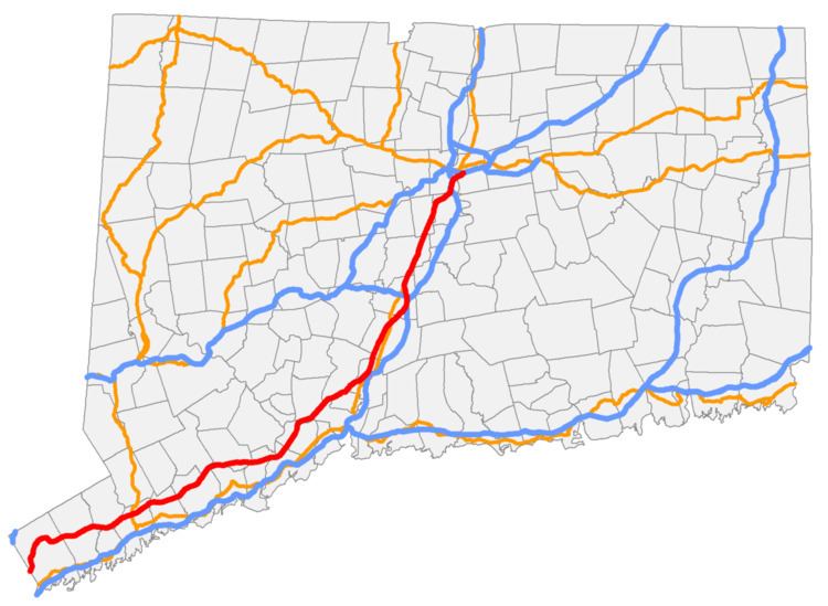
Route 15 is a state highway in the U.S. state of Connecticut that runs 83.53 miles (134.43 km) from a connection with New York's Hutchinson River Parkway in Greenwich, Connecticut to its northern terminus intersecting with Interstate 84 in East Hartford, Connecticut. Route 15 consists of four distinct sections: the Merritt Parkway, the Wilbur Cross Parkway, the Berlin Turnpike, and part of the Wilbur Cross Highway. The unified designation was applied to these separate highways in 1948 to provide a continuous through route from New York to Massachusetts.
Contents
Map of CT-15, Connecticut, USA
Route description
Route 15 begins at the New York border as the Hutchinson River Parkway becomes the Merritt Parkway, a 37.27 mile landscaped limited-access road with many sharp curves and low overpasses. The parkway proceeds in a mostly east-northeasterly direction. Major junctions along the parkway include US 7 in Norwalk, and the Route 8 expressway in Trumbull. As Route 15 crosses the Housatonic River on the Igor I. Sikorsky Memorial Bridge from Fairfield County into New Haven County, it becomes the 29.46 mile Wilbur Cross Parkway, which continues in the same east-northeasterly direction before turning more northeasterly in North Haven. Major junctions include the Milford Parkway (SR 796), a connector providing access to Interstate 95 and US 1 beginning just east of the Sikorsky Bridge; US 5 in Wallingford; and a complex set of interchanges in Meriden providing access to I-91, I-691, and the Route 66 expressway. The parkway ends about a mile north of I-691 as US 5 joins Route 15 and the road becomes a four-lane divided highway with signalized and at-grade intersections known as the Berlin Turnpike. After entering Hartford County, it meets the Route 9 expressway at a complex interchange in Berlin. After 11.21 miles on the turnpike, Route 15 and US 5 become the Wilbur Cross Highway in Wethersfield as the Berlin Turnpike becomes Route 314. After another complex interchange with I-91, it crosses the Connecticut River on the Charter Oak Bridge between Hartford and East Hartford. US 5 leaves the expressway just after the bridge in an interchange that also provides access to the Route 2 expressway. After 5.64 miles on the Wilbur Cross Highway, Route 15 ends as it merges into I-84 east.
There are vehicle restrictions on the Merritt and Wilbur Cross Parkways (e.g., no trucks).
History
The Route 15 designation was created as part of the 1932 state highway renumbering and originally ran from New Haven through Middletown, East Hartford and Stafford Springs to the Massachusetts state line in Union. The original route used the pre-expressway alignment of modern Route 17 to Glastonbury, Main Street to East Hartford center, U.S. Route 5 to the junction with Route 30, then modern Route 30 to Stafford, then modern Route 190 to Union, and modern Route 171 to the Massachusetts state line.
In 1943, a newly constructed two-lane highway (now the Wilbur Cross Highway) between Tolland and Union was opened to traffic. Route 15 was relocated on this new highway and the former Route 15 between Route 74 and Route 190 (then part of Route 20) was redesignated as Route 30. By 1948, the rest of the old two-lane Wilbur Cross Highway to East Hartford had also opened, connecting to the Charter Oak Bridge and the Hartford Bypass. In 1948, the State Highway Department decided to relocate Route 15 to a series of roadways, namely the Merritt Parkway, Wilbur Cross Parkway, Berlin Turnpike, Hartford Bypass, Charter Oak Bridge, and the new Wilbur Cross Highway, creating a modern, high-speed throughway from the New York state line to the Massachusetts state line. The Route 15 designation was applied to the previously unnumbered parkways from Greenwich to Meriden, then overlaid with U.S. Route 5 through East Hartford, then designated on the southern half of the Wilbur Cross Highway to Tolland, connecting with the portion previously designated as Route 15 five years before. The former Route 15 between South Windsor and Tolland was reassigned as an extension of Route 30, and the former Route 15 between New Haven and Glastonbury became redesignated as Route 17.
In 1948, a portion of the Wilbur Cross Parkway between Route 34 and Whitney Avenue had still been under construction. Route 15 was temporarily routed along Route 34, Sherman Avenue (former Routes 5 and 10), Henry Street/Munson Street/Hillside Place/Edwards Street (former Route 5), and Whitney Avenue (former Route 10A). By 1949, the Wilbur Cross Parkway was completed and the temporary Route 15 designation was removed from the surface streets. Further improvements in the Wilbur Cross Highway took place over the next several years and the road became a four-lane divided highway by 1954. In 1968, most of the Wilbur Cross Highway was designated as I-86 and further upgrades to the road were implemented. Route 15 and I-86 overlapped from the current 15/84 junction in East Hartford to the Massachusetts state line. In 1984, the overlap was removed, truncating Route 15 to its current northern end, while at the same time I-86 was redesignated as I-84.