
Traversed by D120 Elevation 1,501 m | Range Jura Mountains | |
 | ||
Similar Grand Colombier, Col de Richemond, Jura Mountains, Mont Colombier, Col de la Colombière | ||
Col du grand colombier
Col du Grand Colombier (el. 1,501 metres or 4,925 feet) is a mountain pass in the Jura mountains in France.
Contents
- Col du grand colombier
- Map of Col du Grand Colombier 01350 Anglefort France
- Cycle racing
- Tour de France
- References
Map of Col du Grand Colombier, 01350 Anglefort, France
This pass lies at the southern extremity of the Jura in the massif of the Grand Colombier. With the Col du Chasseral, it is the highest road pass in the Jura. It passes between the Grand Colombier (el. 1,531 metres or 5,023 feet) and the Croix du Colombier (1,525 metres or 5,003 feet), which is accessible by trail from the pass.
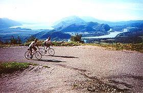
The view from the summit is superb, either down the valley of the Rhône, the Lac du Bourget and the gorges of Val-de-Fier, or the distant peaks of the Alps.
Cycle racing
It is one of the most difficult passes in France, with stretches in excess of 20% on the climb from Artemare via Virieu-le-Petit on the Bugey (western) side. The pass has seen frequent use in cycling, being a regular feature of the Tour de l'Ain and also used in the Critérium du Dauphiné and Tour de l'Avenir.
From Culoz (south), the ascent is 18.3 km. long gaining 1,255 m. in height at an average percentage of 6.9%, but with some sections at 12%. This climb is the direction used on Stage 5 of the 2012 Critérium du Dauphiné and Stage 10 of the 2012 Tour de France.
The Col can also be reached from Anglefort (east), from where it is 15.2 km. long climbing 1,205 m. at an average of 7.9%.
Tour de France
It was visited by the Tour de France for the first time on Stage 10 of the 2012 tour as a Hors Catégorie climb. The leader over the summit was Thomas Voeckler, who went on to take the stage victory in Bellegarde-sur-Valserine.