
Department Ain Intercommunality Bassin Bellegardien Local time Thursday 3:18 PM | Area 15.25 km² | |
 | ||
Weather 11°C, Wind W at 8 km/h, 55% Humidity | ||
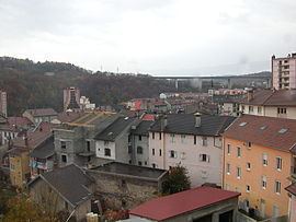
Bellegarde-sur-Valserine is a commune in the Ain department in eastern France.
Contents
Map of 01200 Bellegarde-sur-Valserine, France
Geography
Bellegarde is located at the confluence of the Valserine and the Rhone.
At this spot, the water of the two rivers runs underground, and it was possible to cross both of them easily. Since the building of the Génissiat dam at Injoux-Génissiat, the level of the Rhône was raised several meters but the pertes de la Valserine are still visible.
Bellegarde lies in a valley dominated by the plateau of Retord on the west and the massif of the Grand Crêt d'Eau and the Vuache on the east. The passage created by the Rhône is the principal access to the area around Gex and the north of Lake Geneva.
Traffic
Bellegarde is the transfer station to the Swiss Jura foot railway line.
Twin towns — Sister cities
Bellegarde-sur-Valserine is twinned with: