
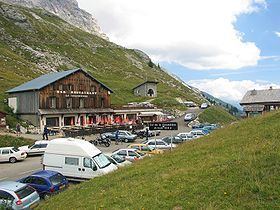
Traversed by D4 Elevation 1,613 m | ||
 | ||
Similar Alps, Col des Aravis, Col de Joux Plane, Cormet de Roselend, Col de la Ramaz | ||
3d tour col de la colombi re 1618m from le grand bornand le reposoir
Col de la Colombière (elevation 1613 m) is a mountain pass in the Alps in the department of Haute-Savoie in France.
Contents
- 3d tour col de la colombi re 1618m from le grand bornand le reposoir
- Map of Col de la ColombiC3A8re 74950 Le Reposoir France
- Pghm intervention et h litreuillage au col de la colombi re
- Details of climb
- Appearances in Tour de France
- References
Map of Col de la Colombi%C3%A8re, 74950 Le Reposoir, France
It connects Cluses in the Arve valley with Le Grand-Bornand in the Bourne valley. The road then leads further to Annecy or over Col des Aravis to the Arly valley and is situated between the Massif des Bornes to the north-west and the Chaîne des Aravis to the south-east.
The pass is not an important traffic route because there are better roads that parallel it, particularly the A40 autoroute.
Pghm intervention et h litreuillage au col de la colombi re
Details of climb
Although the pass is not very high, it is technically difficult for cyclists.
Starting from Scionzier, the climb is 16.3 km long. Over this distance, the climb is 1108 m (an average percentage of 6.8%). The steepest section is 10.2% near the summit. From Le Grand-Bornand, the Col de la Colombière is 11.7 km long. Over this distance, the climb is 690 m (an average percentage of 5.9%).
On May 31, 2015, U.S. Secretary of State John Kerry broke his leg near the start of the climb in Scionzier.
Appearances in Tour de France
The pass was first included in the Tour de France in 1960 and has since featured 21 times, most recently in 2016.