
 | ||
The Coast Miwok are an indigenous people that was the second largest group of Miwok people. The Coast Miwok inhabited the general area of modern Marin County and southern Sonoma County in Northern California, from the Golden Gate north to Duncans Point and eastward to Sonoma Creek. The Coast Miwok included the Bodega Bay Miwok from authenticated Miwok villages around Bodega Bay and Marin Miwok.
Contents
Culture
The Coast Miwok spoke their own Coast Miwok language in the Utian linguistic group. They lived by hunting and gathering, and lived in small bands without centralized political authority. In the springtime they would head to the coasts to hunt salmon and other seafood, including seaweed. Otherwise their staple foods were primarily acorns—particularly from black and tan oak–nuts and wild game, such as deer and cottontail rabbits and black-tailed deer, Odocoileus hemionus columbianus, a coastal subspecies of the California mule deer, Odocoileus hemionus. When hunting deer, Miwok hunters traditionally used Brewer's angelica, Angelica breweri to eliminate their own scent. Miwok did not typically hunt bears. Yerba buena tea leaf were used medicinally.
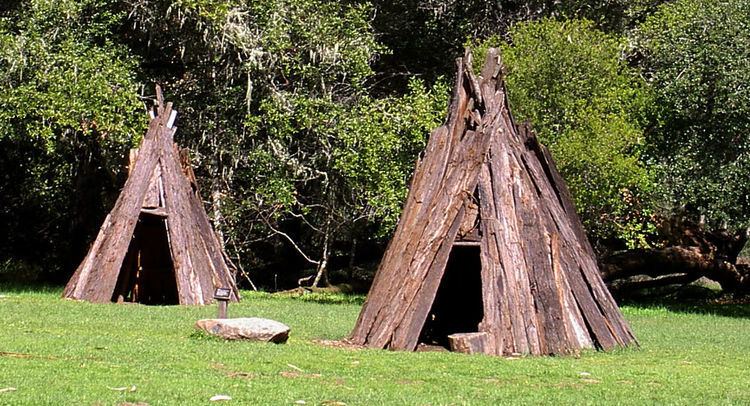
Tattooing was a traditional practice among Coast Miwok, and they burned poison-oak for a pigment. Their traditional houses, called "kotcha" were constructed with slabs of tule grass or redwood bark in a cone-shaped form.
Miwok people are skilled at basketry. A recreated Coast Miwok village called Kule Loklo is located at the Point Reyes National Seashore.
Language
The Coast Miwok language is no longer natively spoken, but the Bodega dialect is documented in Callaghan (1970).
Religion
The original Coast Miwok people world view included animism, and one form of this took was the Kuksu religion that was evident in Central and Northern California. This included elaborate acting and dancing ceremonies in traditional costume, an annual mourning ceremony, puberty rites of passage, shamanic intervention with the spirit world and an all-male society that met in subterranean dance rooms. Kuksu was shared with other indigenous ethnic groups of Central California, such as their neighbors the Pomo, also Maidu, Ohlone, Esselen, and northernmost Yokuts. However Kroeber observed less "specialized cosmogony" in the Miwok, which he termed one of the "southern Kuksu-dancing groups", in comparison to the Maidu and other northern California tribes.
Coast Miwok mythology and narratives were similar to those of other natives of Central and Northern California. The Coast Miwok believed in animal and human spirits, and saw the animal spirits as their ancestors. Coyote was seen as their ancestor and creator god. In their case the earth began with land formed out of the Pacific Ocean.
Traditional narratives
In their myths, legends, tales, and histories, the Coast Miwok participated in the general cultural pattern of Central California.
Authentic villages
The authenticated Coast Miwok villages are:
History
Documentation of Miwok peoples dates back as early as 1579 by a priest on a ship under the command of Sir Francis Drake. Other verification of occupancy exists from Spanish and Russian voyagers between 1595 and 1808. Over 1000 prehistoric charmstones and numerous arrowheads have been unearthed at Tolay Lake in Southern Sonoma County - some dating back 4000 years. The lake was thought to be a sacred site and ceremonial gathering and healing place for the Miwok and others in the region.
Coast Miwok would travel and camp on the coast and bays at peak fishing seasons.
After the Europeans arrived in California, the population declined from diseases introduced by the Europeans. Beginning in 1783, mission ecclesiastical records show that Coast Miwok individuals began to join Mission San Francisco de Asis, now known as Mission Dolores. They started joining that mission in large numbers in 1803, when the marriages of 49 couples from their Huimen and Guaulen local tribes (San Rafael and Bolinas Bay) appeared in the Mission San Francisco Book of Marriages. Local tribes from farther and farther north along the shore of San Pablo Bay moved to Mission San Francisco through the year 1812. Then in 1814 the Spanish authorities began to split the northern groups—Alagualis, Chocoimes (alias Sonomas), Olompalis, and Petalumas—sending a portion of each group to Mission San Francisco and another portion to Mission San Jose in the southeast portion of the San Francisco Bay Area. By the end of the year 1817, 850 Coast Miwok had been converted.
Mission San Rafael was founded by the Spanish Franciscans in Coast Miwok territory in the late fall of 1817. By that time the only Coast Miwok people still on their land were those on the Pacific Coast of the Marin Peninsula, from Point Reyes north to Bodega Bay. The Spanish authorities brought most of the Coast Miwoks who had been at Missions San Francisco and San Jose back north to form a founding population for Mission San Rafael. But some who had married Ohlone or Bay Miwok-speaking Mission Indians remained south of the Golden Gate. Over time in the 1820s Mission San Rafael became a mission for Coast Miwok and Pomo speakers. Mission San Francisco Solano, founded in 1823 in the Sonoma Valley (the easternmost traditional Coast Miwok region), came to be predominately a mission for Indians that spoke the Wappo or Patwin languages.
At the end of the Mission period (1769–1834) the Coast Miwoks were freed from the control of the Franciscan missionaries. At the same time the Mission lands were secularized and ceded to Californios. Most Coast Miwok began to live in servitude on the ranchos for the new California land grant owners, such as those who went to work for General Mariano G. Vallejo at Rancho Petaluma Adobe. The ranch owners were dependent upon the labor pool of Indians with agricultural and ranching skills. Other Miwok chose to live independently in bands like those at Rancho Olompali and Rancho Nicasio.
In 1837, a smallpox epidemic decimated all the native populations of the Sonoma region, and the Coast Miwok population continued to decline rapidly from other diseases brought in from the Spaniards as well as the Russians at Fort Ross.
By the beginning of California statehood (1850), many Miwok of Marin and Sonoma Counties were making the best of a difficult situation by earning their livelihoods through farm labor or fishing within their traditional homelands. Others chose to work as seasonal or year-round laborers on the ranches that were rapidly passing from Mexican ownership into Anglo-American ownership.
Olompali and Nicasio
After Mission San Rafael closed during the 1834-1836 period, the Mexican government deeded most of the land to Californios, but allowed the Indians ex-neophytes to own land at two locations within traditional Coast Miwok territory: Olompali and Nicasio.
The Coast Miwok leader Camilo Ynitia, secured a land grant of 2 sq. leagues known as Rancho Olompali, from Governor Micheltorena of Alta California in 1843, which included the prehistoric Miwok village of Olompali (his home village) and is north of present-day Novato.
The village of Olompali dates back to 500, had been a main center in 1200, and might have been the largest native village in Marin County. Ynitia held onto the Rancho Olompoli land title for 9 years, but in 1852 he sold most of the land to James Black of Marin. He retained 1,480 acres (6.0 km2) called Apalacocha. His daughter eventually sold Apalacocha.
The other Indian-owned rancho was at Rancho Nicasio northwest of San Rafael. Near the time of secularization (1835), the Church granted the San Rafael Christian Indians 20 leagues (80,000 acres, 320 km²) of mission lands from present-day Nicasio to the Tomales Bay. About 500 Indians relocated to Rancho Nicasio. By 1850 they had but one league of land left. This radical reduction of land was a result of illegal confiscation of land by non-Indians under protest by Indian residents. In 1870, José Calistro, the last community leader at Nicasio, purchased the small surrounding parcel. Calistro died in 1875, and in 1876 the land was transferred by his will to his four children. In 1880 there were 36 Indian people at Nicasio. The population was persuaded to leave in the 1880s when Marin County curtailed funds to all Indians (except those at Marshall) who were not living at the Poor Farm, a place for "indigent" peoples.
By the early 20th century, a few Miwok families pursued fishing for their livelihoods; one family continued commercial fishing into the 1970s, while another family maintained an oyster harvesting business. When this activity was neither in season nor profitable, Indian people of this area sought agricultural employment, which required an itinerant lifestyle. The preferred locality for such work was within Marin and Sonoma counties.
Recognition
The Federated Indians of Graton Rancheria, formerly the Federated Coast Miwok, gained federal recognition of their tribal status in December 2000. The new tribe consists of people of both Coast Miwok and Southern Pomo descent.
Population
Estimates for the pre-contact populations of most native groups in California have varied substantially. (See Population of Native California.) Alfred L. Kroeber put the 1770 population of the Coast Miwok at 1,500. Sherburne F. Cook raised this figure to 2,000.
The population in 1848 was estimated as 300, and it had dropped to 60 in 1880.