
J F M A M J | F M A M J J | |
 | ||
The climate of Houston is classified as humid subtropical. August normally ranks as the warmest month at 84.6 °F (29.2 °C) and January the coldest month at 53.1 °F (11.7 °C).
Contents
- Summer
- Autumn
- Winter
- Spring
- Precipitation
- Extreme weather
- Hurricanes and tropical storms
- Flooding
- Tornadoes
- Winter storms
- El Nio
- Environmental issues
- Air pollution
- Water pollution
- References
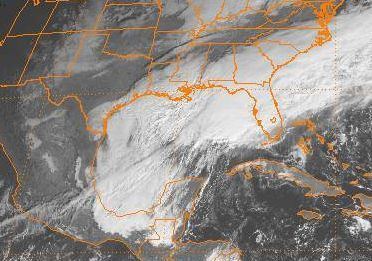
The normal annual precipitation measures 49.77 inches (1,264 mm). Occasional severe weather of Houston mostly takes the form of flooding. Supercell thunderstorms sometimes bring tornadoes to the area, most commonly during spring. Houston sometimes experiences tropical cyclones during the Atlantic hurricane season, which can bring heavy rain and significant damage to the city. The last hurricane to hit was Hurricane Ike in 2008.
Summer
June through August in Houston is very hot and humid, often with scattered afternoon showers and thunderstorms. At George Bush Intercontinental Airport, the normal daily high temperature peaks at 95.0 °F (35.0 °C) on 5–12 August, with a normal of 102.4 days per year at or above 90 °F (32 °C) and 3.5 days per year at or above 100 °F (38 °C). The average relative humidity ranges from over 90 percent in the morning to around 60 percent in the afternoon. Summer temperatures in Houston are very similar to average temperatures seen in tropical climates, such as in the Philippines and Central America. The value of relative humidity results in a heat index higher than the actual temperature. The highest temperature ever recorded at George Bush Intercontinental Airport was 109 °F (43 °C) on September 4, 2000 and on August 27, 2011. On June 29, 2013, the temperature at George Bush Intercontinental Airport reached 107 °F (42 °C), the highest ever recorded in June. Heat stroke can strike people who stay outdoors for long periods of time during the summer, making hydration essential for outdoor work and recreational activity. The 2014 summer season did not yield 100+ degree weather in response to the monsoon-esque rainfall during late June to August during a period where the Pacific Coast off Central America was heating up which evolved into the 2014-16 El Nino event - this cycle one existed between 1971-76 during post-El Nino cycles.
Heat and humidity of Houston make air conditioning important in day-to-day life. Most indoor workers spend the hottest part of the day in air conditioning. After World War II, air conditioning stimulated the growth of Houston, called the most air-conditioned city in the world in 1950. For construction workers, landscapers, and others who must work outdoors, there is little relief from the summer heat and humidity. Industrial workers, automobile mechanics and others who usually work in non-air conditioned indoor spaces often rely on large electric fans to provide some relief.
Autumn
Autumn in Houston is warm, with temperatures averaging in the upper 60s to lower 80s °F (20-28 °C) during the day and in the 50s to lower 60s °F (10-17 °C) at night. Cool fronts that move through the region during the fall can bring rain. Hurricanes can move into the area from the Gulf of Mexico, bringing heavy rains and high winds. However, most years see little or no significant hurricane activity. Flooding most frequently occurs in October and November. Most of these flood events result from remnants of Eastern Pacific cyclones interacting with upper-level boundaries; October 2015 was the latest example of such an occurrence, wherein the remnants of Hurricane Patricia brought over 9 inches of rain to the city. The latest hurricane to reach Texas was Hurricane Ike (2008).
Winter
Winters in Houston are relatively mild and temperate compared to most areas of the United States, though Houston does get much colder than places like South Florida and South Texas. Houston is more prone to extreme variation in the winter months than cities like San Diego, California or Tampa, Florida. The average high in January, the coldest month, is 62.9 °F (17.2 °C) and the low 43.2 °F (6.2 °C), George Bush Intercontinental Airport sees an average of 9.6 days per year of freezing temperatures. Cold fronts during the winter drop nighttime lows into the 30s but usually above freezing. The coldest weather of the season often includes a period about three weeks with temperatures in the low 30s to mid-40s at night. Hard freezes occur only uncommonly; however, George Bush Intercontinental Airport has recorded a freeze every winter since it opened in 1969. The coldest temperature ever recorded at George Bush Intercontinental Airport was 7 °F (−14 °C) on December 23, 1989. Elsewhere, the temperature in Houston dropped to 5 °F (−15 °C) on January 18, 1930.
In December, southward-moving cold fronts can bring cold rain, low wind chills, and, rarely, frozen precipitation. Early January is the coldest time of the year, with temperatures moderating slightly by February.
Spring
Spring comes with a gradual warm up from winter, lasting from March 20 through May. Temperatures are generally not hot yet, averaging from 75–82 °F (23.9–27.8 °C) in the day and 56–64 °F (13.3–17.8 °C) at night. Spring thunderstorms are common, often with spectacular lightning shows. This rainfall prompts Houston's 10-month-long "growing season" to begin. April sees the return of many types of insects, including butterflies and mosquitoes, to Houston's warm climate.
Precipitation
Rainfall is the most common form of precipitation in Houston. The wettest month is June, with an average of 5.93 inches (151 mm) of rain. Houston normally receives 49.77 inches (1,264 mm) of precipitation on 104.0 days annually. The most precipitation to fall in one year was 83.02 inches (2,108.7 mm) which occurred in 1979. Houston has received less than 20 inches (510 mm) of rain only once: 17.66 inches in 1917. Flash flood warnings are common all year, and due to the flat landscape, heavy rains often threaten life and property in the city. Sea breeze showers which are monsoon-like are common throughout the Texas Gulf Coast area (from Brownsville to the Florida Peninsula) which has a similar climate to areas like Mumbai and Kolkata - locals refer to the sea breeze showers as the Gulf Coast Monsoon (or the Texas Monsoon), despite Houston being 50 feet above sea level. The sea breeze showers are also a contributor to the North American Monsoon.
Sleet, snow, and ice rarely occur during most winters. Hail can accumulate, but only in small quantities.
Extreme weather
Houston has occasional severe weather, mostly flooding. Hurricanes that have the potential to landfall bring severe damage to the area. Seven major hurricanes have hit the Galveston and Houston areas in the past 100 years. Four have done significant damage to Houston.
Hurricanes and tropical storms
Because Houston is on the Gulf of Mexico, the city has a small chance of being hit by hurricanes or tropical storms every hurricane season (June through November).
In 1837 the Racer's Storm passed just to the south of the town, raising water levels four feet. The Great Hurricane of 1900 destroyed the nearby (and then much bigger) city of Galveston, which is situated on a barrier island 50 mi (80 km) southeast of downtown Houston. That hurricane weakened to a tropical storm by the time it reached Houston. The periphery of Hurricane Carla hit the city in 1961, causing major damage to Houston. At the time of landfall, Carla was the most powerful tropical system to hit the Texas coast in over 40 years. In 1983, the city was struck squarely by Hurricane Alicia, causing one billion dollars of damage to the city during a down period in the city's economy.
The most destructive and costly natural disaster in Houston history was Tropical Storm Allison of 2001, which dumped up to 37 inches (940 mm) of rain on parts of the city over a five-day period. Area flooding was catastrophic and widespread. The storm completely overwhelmed the flood control system and caused 22 deaths in Houston and $6.05 billion (2006 USD) in damage. It is the only tropical storm in history to have its name retired.
Tropical Storm Erin made landfall in August 2007 with strong rains. A total of 9 inches (230 mm) of rain fell elsewhere than George Bush Intercontinental Airport on August 16, and many roads and neighborhoods were flooded. Metropolitan Transit Authority of Harris County, Texas, halted its light rail and bus services in view of the effects. Four deaths in the city were attributed to the storm. The Houston Fire Department reported 72 rescue operations.
Hurricane Ike made landfall near Galveston, Texas in September 2008. Although only a category 2 storm (out of 5), Ike brought moderate rain but high winds for an unusually long duration (upwards of nine hours). The roof of Reliant Stadium (home of the Houston Texans NFL team) was damaged and windows were blown out of several high-rise buildings in downtown Houston. Storm surge affected areas around Galveston Bay, stripping some coastal islands of homes. Devastated Galveston Island much resembled a war zone. Authorities prohibited non-emergency access to the island for many weeks. Hurricane Ike left ninety percent of people in the Houston Area without power. Never before had the city experienced such widespread or long-term power outage: no air conditioning, no refrigeration, no lights, and no phones. Day-to-day business slowed immensely. Area grocery stores were stripped bare and sold water and ice for cash by flashlight. Trucks from around the country brought in emergency supplies, especially water and ice. Most of the city was without power for a week — some for 2 to 3 weeks.
Flooding
Flooding is a recurring problem in Houston. It is especially severe in low-lying areas on the far east end of town along the San Jacinto River. The flat wetlands and paved-over coastal prairie around Houston drain slowly and easily flood. The area is drained by a network of bayous (small, slow-moving rivers, often dredged and enlarged to increase volume) and man-made drainage ditches, which are usually dry most of the year. Due to the ubiquity of overdevelopment and the huge amounts of concrete in the city, drainage is insufficient during times of especially heavy rainfall. In fall, cool fronts bring in rainstorms and flooding is not uncommon. This might flood certain low-lying intersections, but doesn't generally affect citizens or the business of the city. However, occasionally very heavy thunderstorms dump so much water on the city that widespread congestion and even property damage in low-lying areas result. Tropical Storm Allison in 2001 was so severe that many parts of town that had never flooded before were flooded seriously. Interstate 10 near downtown, which is below grade, was covered by over 10 ft (3.0 m) of water. Another storm happened in May 2015 that had a similar impact on Houston, causing several highways to be closed due to the bayou overflowing.
Tornadoes
Unlike Dallas, Houston is not in Tornado Alley. Smaller tornadoes can occur during severe weather. They are most likely to be found along frontal boundaries of an air mass during the spring months. Tornadoes in Houston usually measure a weak F1 on the old Fujita scale, and cause light to moderate damage to well-constructed buildings. The strongest recorded tornado in Houston history was an F4 on November 21, 1992, part of a large outbreak of tornadoes in Harris County.
Winter storms
There are usually a few days of freezing (< 32 °F (0 °C)) temperatures each year, though the average low in January, the coldest month, is still only 43 °F (6 °C) or 24 °F (−4 °C).
Snow falls infrequently in the Magnolia City. When it does occur, it almost invariably melts immediately on the ground with light accumulation on roofs and raised surfaces. Since 1895, it has only snowed 35 times in Houston at an average of about once every 10 years, though some decades have several instances of recorded snowfall while others have only one each (e.g., the 1930s and 1950s). There were more incidences of snow in the 1980s on average than any other decade recorded, but the 2000s also witnessed more frequent and record-breaking snows:
The December 21–24, 2004 North American winter storm brought a white Christmas to the region. The average has the lowest recorded temperature for that month, 24 °F (−4 °C).
The 2004 Christmas Eve snowstorm brought a never-before-seen white Christmas to the region. Average annual snowfall is very, very little above zero, being less than the measurable amount of 0.1 inches (2.5 mm). In descending order of frequency, the most snow has fallen in January, followed by February, December, and finally a single occurrence on March 10, 1932, which was also the lowest recorded temperature for that month, 22 °F (−6 °C).
Occurrences of freezing rain, also known as ice storms, are slightly less rare than snow in Houston. Some of the most recent ice storms occurred in 1997, 2007, and on February 4, 2011. An overnight event occurred from January 23, 2014 to January 24, another significant icing occurred a few days later on January 28, and a third event took place on March 4. These storms can be very disruptive since road crews are not equipped to handle such rare events over the city's expansive size. When ice occurs, roads and schools are usually closed. The city's Office of Emergency Management encourages driver's to "avoid driving unless absolutely necessary... if roadways are at risk of icing." Typically, such ice storms affect mainly the northern/western areas of the metro, while the southern/eastern areas are left with just cold rain.
El Niño
During El Niño, Houston winters are cooler and wetter than normal due to a stronger southern jet stream. Increased clouds during El Nino winters are what keep the temperatures from warming up. La Niña is where the jet stream is further north resulting in a warmer and drier winter. The chance of damage from tropical storms and hurricanes also goes up during La Niña events due to decreased Atlantic wind shear. Post-El Niño weather during the spring usually result in increased rainfall, as demonstrated with the Memorial Day 2015 and Tax Day/Memorial Day/early June 2016 flood events where the Houston Metro area (and the rest of the state) experienced a climate similar to the South Asian summer monsoon (in this case with the state of Texas where a stalled low pressure system [usually from an upper level low from the northeast Pacific Ocean which migrates east where the northern polar jet stream form the usual omega blocks] originates over the Four Corners region or the Sierra Madre Occidental/Sierra Madre Oriental mountain ranges in northern Mexico).
Environmental issues
Houston has had a troubled past with pollution of many types. This is due to the fact that Houston has been the home for the oil and gas industry since its inception in the early 1900s when there was little environmental regulation. Harris County, where the bulk of the city has been historically located, is home to 15 Environmental Protection Agency Superfund sites, more than any other area in Texas. The list contains numerous companies, streets and waterways that have been considered hazardous to humans in various ways.
Air pollution
Houston is well known for its oil and petrochemical industries, which are leading contributors to the city's economy. The industries located along the ship channel, coupled with a growing population, have caused a considerable increase in air pollution for the city each year. Houston has excessive ozone levels and is ranked among the most ozone-polluted cities in the United States. Ground-level ozone, or smog, is Houston's predominant air pollution problem. In 2011, Houston was ranked as the 17th most polluted city in the US, according to the American Lung Association. A 2007 assessment found the following twelve air pollutants to be definite risks to health in Houston:
The State of Texas concluded that, since 2000, the Manchester neighborhood in eastern Houston had the highest annual averages of 1,3-Butadiene of any area in Texas. Houston's air quality has often been compared to Los Angeles and Beijing.
Houston has introduced many programs since the 2000 federal order to reduce air pollution in the city. The most notable project was the METRORail light rail system constructed in 2004. The light rail system was designed to encourage Houstonians to utilize public transportation instead of their automobiles. To date it has had limited success and been a source of controversy and cost overruns.
Water pollution
Houston has also seen recent improvements to the city's waterways. The banks of Buffalo Bayou have been cleaned of garbage and have been turned into jogging trails and parks. Since the mid-1990s, Houston has seen a great increase in wildlife along the bayou due to many successful cleaning attempts. The Port of Houston has not seen any major cleaning attempts.