
Founded January 29, 1822 Congressional district 5th Website www.clearfieldco.org Area 2,989 km² Unemployment rate 5.9% (Apr 2015) | Designated September 17, 1982 Population 81,174 (2013) | |
 | ||
Points of interest Bee Kind Winery, Clearfield County Historical, Grice Clearfield Communi Destinations | ||
Clearfield County is a sixth-class county located in the U.S. state of Pennsylvania. As of the 2010 census, the population was 81,642. The county seat is Clearfield, and the largest city is DuBois. The county was created in 1804 and later organized in 1822.
Contents
- Map of Clearfield County PA USA
- History
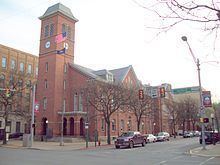
- Location of county government
- Early industry
- Geography
- Major highways
- Demographics
- Micropolitan Statistical Area
- Politics and government
- County commissioners
- Other county offices
- Correctional facilities
- Colleges and universities
- Community junior and technical colleges
- Public school districts
- Intermediate unit
- Correctional institution schools
- Private schools
- Libraries
- Recreation
- Camping
- Huntingfishing
- Sporting
- Points of interest
- Communities
- City
- Census designated places
- Unincorporated communities
- Population ranking
- References
Map of Clearfield County, PA, USA
Clearfield County comprises the DuBois, PA Micropolitan Statistical Area, which is also included in the State College-DuBois, PA Combined Statistical Area.
History
Clearfield County was formed by the Act of Assembly by the second Governor of Pennsylvania at the time, Thomas McKean on March 26, 1804. The county was created from parts of the already created counties of Huntingdon and Lycoming. The name for the county was most likely derived from the many cleared fields of the valleys surrounding Clearfield Creek and West Branch of the Susquehanna River, formed by the bison herds and also by old corn fields of prior Native Americans tribes.
Location of county government
The first board of county commissioners to the county were Roland Curtin, James Fleming and James Smith, all appointed by Governor McKean in 1805. The first act the commissioners did was to create a local government or seat of the newly created county. They came upon land owned at the time by Abraham Witmer at a village known as Chincleclamousche, named after the Native American chief of the Cornplanter's tribe of Senecas. Clearfield became the new name of the old village.
Early industry
The two major industries of the county in the mid-1800s until the early 1900s was lumber and coal. Lumber was still being floated down the West Branch of the Susquehanna up until 1917. Coal remains the main industry of the county to this day.
Geography
According to the U.S. Census Bureau, the county has a total area of 1,154 square miles (2,990 km2), of which 1,145 square miles (2,970 km2) is land and 9.2 square miles (24 km2) (0.8%) is water. It is the third-largest county in Pennsylvania by land area and fourth-largest by total area. The West Branch Susquehanna River flows through the county bisecting the county seat along the way.
The mountainous terrain of the county made traffic difficult for early settlers. Various Native American paths and trails crossing the area were used intermittently by settlers, invading armies, and escaped slaves travelling north along the Underground Railroad. A major feature located in Bloom Township, Pennsylvania within the county is known as Bilger's rocks and exhibits fine examples of exposed sandstone bedrock that was created during the formation of the Appalachian Mountains.
The shape of Clearfield County bears an amazing resemblance to that of the state of Arkansas.
Major highways
Demographics
As of the census of 2000, there were 83,382 people, 32,785 households, and 22,916 families residing in the county. The population density was 73 people per square mile (28/km2). There were 37,855 housing units at an average density of 33 per square mile (13/km2). The racial makeup of the county was 97.40% White, 1.49% Black or African American, 0.12% Native American, 0.26% Asian, 0.01% Pacific Islander, 0.26% from other races, and 0.46% from two or more races. 0.56% of the population were Hispanic or Latino of any race. 22.9% were of German, 13.6% American, 10.2% English, 9.9% Irish, 9.1% Italian and 6.0% Polish ancestry according to Census 2000.
There were 32,785 households out of which 29.70% had children under the age of 18 living with them, 56.60% were married couples living together, 9.30% had a female householder with no husband present, and 30.10% were non-families. 26.30% of all households were made up of individuals and 13.10% had someone living alone who was 65 years of age or older. The average household size was 2.44 and the average family size was 2.94.
In the county, the population was spread out with 22.70% under the age of 18, 7.70% from 18 to 24, 28.80% from 25 to 44, 23.90% from 45 to 64, and 16.90% who were 65 years of age or older. The median age was 39 years. For every 100 females there were 99.50 males. For every 100 females age 18 and over, there were 97.50 males.
Micropolitan Statistical Area
The United States Office of Management and Budget has designated Clearfield County as the DuBois, PA Micropolitan Statistical Area (µSA). As of the 2010 U.S. Census the micropolitan area ranked 6th most populous in the State of Pennsylvania and the 64th most populous in the United States with a population of 81,642. Clearfield County is also a part of the State College-DuBois, PA Combined Statistical Area (CSA), which combines the populations of both Clearfield and Centre County areas, as well as the State College area. The Combined Statistical Area ranked 9th in the State of Pennsylvania and 123rd most populous in the United States with a population of 235,632.
Politics and government
As of October 2014, there are 50,846 registered voters in Clearfield County.
While the county registration tends to be evenly matched between Democrats and Republicans, the county trends Republican in statewide elections. In 2006, Democrat Bob Casey Jr. received 55% of its vote when he unseated incumbent Republican US Senator Rick Santorum and Ed Rendell received 50.2% of the vote against Lynn Swann. Each of the three row-office statewide winners carried Clearfield in 2008.
County commissioners
Other county offices
Correctional facilities
Colleges and universities
Community, junior and technical colleges
Public school districts
Intermediate unit
Correctional institution schools
Private schools
Libraries
Recreation
There are two Pennsylvania state parks in Clearfield County.
Clearfield County is also home to the largest wild area in Pennsylvania, the Quehanna Wild Area. A culturally and historically significant natural formation of massive sandstone megaliths can be found at Bilger's rocks.
Camping
Lodging/Camping
Hunting/fishing
Hunting
Fishing
Sporting
Golf
Points of interest
Communities
Under Pennsylvania law, there are four types of incorporated municipalities: cities, boroughs, townships, and, in at most two cases, towns. The following cities, boroughs and townships are located in Clearfield County:
City
Census-designated places
Census-designated places are geographical areas designated by the U.S. Census Bureau for the purposes of compiling demographic data. They are not actual jurisdictions under Pennsylvania law. Other unincorporated communities, such as villages, may be listed here as well.
Unincorporated communities
Unincorporated areas are region of land that are not parts of any incorporated boroughs, cities, or towns.
Population ranking
The population ranking of the following table is based on the 2010 census of Clearfield County.
† county seat