
District Karviná Elevation 330 m (1,080 ft) Area 10.61 km² Population 1,088 (2006) | First mentioned 1229 Postal code 735 61 Local time Monday 5:13 AM | |
 | ||
Weather 6°C, Wind SW at 14 km/h, 88% Humidity Points of interest Archeopark Chotěbuz, Olza, Fish house | ||
Chotěbuz (Polish: Kocobędz , German: Kotzobendz) is a village in Karviná District, Moravian-Silesian Region of the Czech Republic. It lies on the border with Poland, on the left bank of the Olza River, in the historical region of Cieszyn Silesia. It has 1,033 inhabitants (2001 census), 21.3% of the population are the Poles.
Contents
Map of 735 61 Chot%C4%9Bbuz, Czechia
The name of the village is derived from an old Slavic personal name Chociebąd (Kocobąd, as the beginning Ch was often transformed into K).
History
The village is one of the oldest in Cieszyn Silesia. There was a fortified settlement (gród) of the Golensizi tribe in this place called Cieszynisko (or Old Cieszyn). It was an important center since the 8th century. After decline of the settlement at the beginning of the 12th century, it was relocated to Wzgórze Zamkowe (castle hill) in Cieszyn. Near the old place a new settlement was created, Podobora. It is today an archaeological site and was partly rebuilt to form archeopark which is possible to visit.
The village was first mentioned in the document of Pope Gregory IX issued in 1229 among villages belonging to Benedictine abbey in Tyniec, as Koczobontz. In 1268 it was bestowed by Władysław Opolski to the newly established Benedictine abbey in Orlová.
Politically it belonged then to the Duchy of Opole and Racibórz and Castellany of Cieszyn, which was in 1290 formed in the process of feudal fragmentation of Poland and was ruled by a local branch of Piast dynasty. In 1327 the duchy became a fee of the Kingdom of Bohemia, which after 1526 became part of the Habsburg Monarchy.
After Revolutions of 1848 in the Austrian Empire a modern municipal division was introduced in the re-established Austrian Silesia. The village as a municipality was subscribed to the political and legal district of Cieszyn. According to the censuses conducted in 1880, 1890, 1900 and 1910 the population of the municipality grew from 975 in 1880 to 1,173 in 1910 with a majority being native Polish-speakers (between 95.1% and 97.1%) accompanied by a small German-speaking minority (at most 39 or 3.4% in 1910) and Czech-speaking (at most 17 or 1.5% in 1910). In terms of religion in 1910 majority were Protestants (52.6%), followed by Roman Catholics (46.8%), 5 Jews and 3 persons adhering to another faiths.
After World War I, fall of Austria-Hungary, Polish–Czechoslovak War and the division of Cieszyn Silesia in 1920, it became a part of Czechoslovakia. Following the Munich Agreement, in October 1938 together with the Zaolzie region it was annexed by Poland, administratively adjoined to Cieszyn County of Silesian Voivodeship. It was then annexed by Nazi Germany at the beginning of World War II. After the war it was restored to Czechoslovakia.
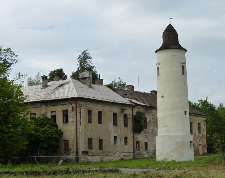
Remains of an old Gothic fort from the 13th century still remain, in its vicinity a Renaissance fort was later built. It was eventually rebuilt into a château at the beginning of the 19th century by the new owner. The Château gained its current look in 1875-1879, when it was completely rebuilt. It was again renovated in 1947.
From 1974 to 1997 Chotěbuz was administratively a part of Český Těšín.
There is a border crossing with Poland in the village, one of the largest in the country and the largest between the Czech Republic and Poland. It is connected with the Polish one by the long bridge built in 1991 running along the Olza River.