
Elevation 9,759 ft (2,975 m) Country United States of America | Highest point Chiricahua Peak | |
 | ||
Length 35 mi (56 km) NW, then SW Width 21 mi (34 km) (arc-shape)-N-S Borders on Dos Cabezas Mountains-NWSan Simon Valley-NE & ESan Bernardino Valley-SEPedregosa Mountains-SSulphur Springs Valley-NW, W & SW Similar Dragoon Mountains, Fort Bowie, Chiricahua Peak, Pinaleno Mountains, Dos Cabezas Mountains | ||
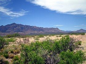
The Chiricahua Mountains massif is a large mountain range in southeastern Arizona which is part of the Basin and Range province of the west and southwest USA and northwest Mexico; the range is part of the Coronado National Forest. The highest point, Chiricahua Peak, rises 9,759 feet (2,975 m) above sea level, approximately 6,000 feet (1,800 m) above the surrounding valleys.
Contents
- Map of Chiricahua Mountains Arizona 85625 USA
- HistoryEdit
- Geology overviewEdit
- Flora and faunaEdit
- References
Map of Chiricahua Mountains, Arizona 85625, USA
The Chiricahua Mountains, and other associated ranges, along with Sulphur Springs Valley on the west and the San Simon Valley on the east, form the eastern half of Cochise County in southeast Arizona. The Pedregosa Mountains are found at the southern end of the Chiricahua Mountains, while the Swisshelm Mountains are located to the southwest. The northwest end of the Chiricahua mountains continue as the Dos Cabezas Mountains beyond Apache Pass and the Fort Bowie National Historic Site. Access to the Chiricahua Mountains and Coronado National Forest is through Willcox from the north, Douglas from the south, and Rodeo from the east.
HistoryEdit
The earliest evidence of humans in the vicinity of the Chiricahua Mountains are Clovis archeological sites such as Double Adobe Site in the Whitewater Draw tributary of Rucker Creek north of Douglas. Subsequently, the Cochise culture another pre-ceramic based culture spanning 3000 - 200 BCE was defined from sites around the Chiricahua Mountains, including Cave Creek Canyon. Following the transition to ceramics diagnostic ceramics characteristic of Mogollon culture and its local variants, the Mimbres culture, are found spanning the period from 150 BCE - 1450. The influx of other indigenous peoples, such as the Chiricahua Apaches, including the leaders Cochise and Geronimo occupied the area until forced removal in the late 19th century.
The first recorded mining claim in the Chiricahua Mountains was the Hidden Treasure claim filed in 1881 and mining has continued intermittently to the present with the greatest periods of activity occurring in the 1920s and 1950s.
More recently, the Chiricahuas have fallen into use by people smugglers and the drug cartels, who position lookouts on their peaks to warn of Border Patrol activities.
Geology overviewEdit
The Chiricahua Mountains are an uplifted structural block of the Basin and Range. The mountains contain Precambrian basement rocks, Paleozoic and Cretaceous sedimentary rocks around a caldera complex formed by volcanic eruptions and intrusions 35 - 25 million years ago. The last major eruption, 27 million years ago, created the Turkey Creek Caldera and laid down 2,000 feet (610 m) of volcanic ash which fused into welded rhyolite tuff. Subsequent erosion has created mountain ridges covered in stone spires and stone columns, hoodoos, that rise up out of the forest. These natural features, preserved in the Chiricahua National Monument, are composed of Rhyolite Canyon Tuff.
A one to two mile wide band of sedimentary rock running southeast to northwest from south of Portal through Paradise and up to the Dos Cabezas Mountains is the source of mineralized deposits. The largest of the mines developed in the California district of the Chiricahua Mountains was the Hilltop mine which consisted of 3 interconnected levels totaling 6,098 metres (20,007 ft).
Flora and faunaEdit
The Chiricahua Mountains are a bio-diverse area which are composed of numerous sky islands. Five of the 9 life zones are found in the Chiricahua Mountains. Three hundred and seventy-five avian species have been recorded from the Chiricahua Mountains; some are largely Mexican species for which southern Arizona is the northern limits of their ranges. Other animals of note include ocelots, jaguars, mountain lions, nine-banded armadillo, black bears, and white-tailed deer.
With the base of the Chiricahuas at about 3,600 feet (1,100 m), the range covers about 6,000 feet (1,800 m) in elevation. Grasslands and desert cover the base of the range, with ponderosa pine and Douglas fir at the highest elevations. Cave Creek Canyon on the east side is home to the American Museum of Natural History Southwest Research Station and the small towns of Portal and Paradise.