
Type Geological formation Region Colorado Plateau | Unit of Chinle Formation | |
 | ||
Underlies Petrified Forest Member and other sub-units, Chinle Formation Overlies Moenkopi Formation units-(250-225 Ma), after erosion unconformity
Temple Mountain Member-(lowest Chinle Formation), Moenkopi Formation-(Monument Valley, Arizona-Utah), De Chelly Sandstone-(50 ma erosion unconformity-Canyon De Chelly National Monument) Thickness 200 feet (61 m) maximum variable Extent southeast perimeter Black Mesa (Arizona)-NNW; Defiance Plateau-(Uplift)-E & NE; north perimeter foothills White Mountains-S; Painted Desert-NW & W Primary Conglomerate, Sandstone, Siltstone | ||
Shinarump conglomerate
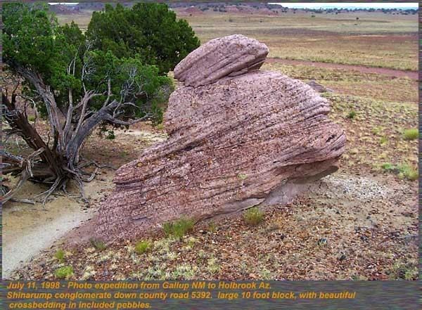
The early Late Triassic conglomerate called the Shinarump Conglomerate, formally the Shinarump Member of the Chinle Formation, is a highly resistant coarse-grained sandstone and pebble conglomerate, sometimes forming a caprock because of its hardness, cementation, and erosion resistance. The Shinarump is found throughout the Colorado Plateau with significant exposures as the canyon rimrock in the vicinity of Canyon De Chelly National Monument, at the north-northeast of the Defiance Plateau/Defiance Uplift. At Canyon De Chelly the Shinarump Conglomerate was laid down upon De Chelly Sandstone-(280 Ma, an erosion unconformity of 50 my), in a region at the west foothill region of the mostly north-south trending Chuska Mountains of northeast Arizona – northwest New Mexico.
Contents
Just northwest of Canyon De Chelly, the Shinarump also forms a caprock in Monument Valley across the border region of northern Arizona – and southern Utah. The Shinarump Conglomerate there is laid upon units of the Moenkopi Formation and remain as resistant caprocks preserving the vertical cliffs of De Chelly Sandstone and other units of the Monument Upwarp/Monument Uplift. The associated Black Mesa (Arizona)-Defiance Uplift extends southeast from Monument Valley into the western border region of New Mexico. The relatively steep east dip of geology units results in increasingly younger geologic units eastwards into New Mexico.
Monument Valley and Canyon De Chelly caprock
In Monument Valley, of Arizona and south Utah, only larger landforms still contain the protective caprock of the Shinarump Conglomerate. The vertical cliffs of highly resistant De Chelly Sandstone protect the highly erodable Organ Rock Formation that forms 'erosion skirts' at the base of the vertical monuments in Monument Valley. For larger mesas, or larger connected land forms, where the more erodable overlying Moenkopi Formation, has not been lost, (with the caprock Shinarump also being undermined), larger sections of Shinarump are thus preserved. Perimeter mesas in the Monument Valley region have the caprock protecting the upper surface, plants, and alluvium from easy erosion of the landform surface.
At Canyon de Chelly, the trail to White House Ruin, descends through the Shinarump Conglomerate, but also has a tributary slot canyon landform with large accumulations of the Shinarump erosional debris on the slot-canyon floor. The trail then descends through the cross–bedded cliffs (fossil sand dunes) of the De Chelly Sandstone.
Geologic history
The river systems which deposited the Shinarump Conglomerate were slow, meandering rivers with oxbow lakes.
The partial geologic sequence is as follows, up to the latest Petrified Forest Member:
Petrified Forest Member, Late Triassic, 215 Ma Shinarump Conglomerate, 225 Ma Holbrook Member, Moenkopi, Middle Triassic, 240 Ma Virgin Limestone Member, Moenkopi, (245-240 Ma) Timpoweap and Sinbad members of the Moenkopi Formation, Early Triassic, 245 MaBy the end of the Early and Middle Triassic the 'Triassic Seas' of the western ocean edge of the North American continent were retreating northwest with deposition of the Shinarump (225 Ma) and Petrified Forest Member (215 Ma). Highlands existed in southern Arizona and New Mexico, and in central and eastern regions of Nevada. These source areas provided the volcanic units of the Petrified Forest Member. The varied composition and oxidation of the included volcanic material provide the colorful units of the Chinle Formation of the Painted Desert, and specifically the units in Petrified Forest National Park at the southeast of the Painted Desert. The desert extends in an arc-shape, paralleling the northwest–by–southeast lineage of the Mogollon Rim, but turns due-north, east of Flagstaff, Arizona, on the east border of the San Francisco volcanic field region, as the Little Colorado River turns north, then northwest to enter the Grand Canyon region. This arc-shaped desert surrounds the south and west border of Black Mesa, the Monument Valley to the north, and the Deiance Plateau to the southeast. The southeast also has a perimeter of the Puerco River which flows southwestwards out of New Mexico and merges into the Little Colorado River. The caprock remainders of the Shinarump Conglomerate lie to north-northeast of the Defiance Uplift-Monument Upwarp.