
Population 541 (2001) Sovereign state United Kingdom Local time Saturday 2:22 AM | OS grid reference SP9972 Post town WELLINGBOROUGH Dialling code 01933 | |
 | ||
Weather 8°C, Wind S at 10 km/h, 92% Humidity | ||
Usaf memorial at chelveston northamptonshire
Chelveston is a small village in Northamptonshire, England forming part of the East Northamptonshire district. It is about 2 miles (3.2 km) east of Higham Ferrers and 7 miles (11.3 km) east of Wellingborough on the B645 (former A45 road) from Higham Ferrers to St Neots. To the south is the hamlet of Caldecott and the settlement of Chelston Rise which together comprise the civil parish of Chelveston cum Caldecott. The population is now included in the civil parish of Chelveston cum Caldecott.
Contents
- Usaf memorial at chelveston northamptonshire
- Map of Chelveston Wellingborough UK
- Wind turbines chelveston
- History
- Heritage assets
- RAF Chelveston
- Demography
- Chelston Rise
- Nearby Settlements
- References
Map of Chelveston, Wellingborough, UK
Wind turbines chelveston
History
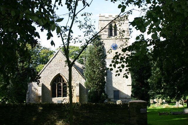
The last lords of the manor of Chelveston were the Disbrowe family, and the last lord, Lt. Col. Henry Edward Disbrowe Disbrowe-Wise CBE, who had inherited the title from his mother, sold off the last of the family's estate properties in Chelveston at auction in July 1919. Disbrowe-Wise moved to other family properties in South Derbyshire. The parish church is dedicated to St John Baptist and is mostly 13th century. The north arcade is 1849-50 by Edmund Francis Law, a Northampton architect.
Heritage assets
The following buildings and structures are listed by Historic England as of special architectural or historic interest.
RAF Chelveston
Nearby is the former airfield of RAF Chelveston. A new memorial to the 305th Bombardment Group (Heavy) who operated out of the airfield, was unveiled in the centre of the village on 26 May 2007.
Demography
Chelston Rise
Beyond Caldecott is a settlement of 50 houses which were formerly used by the US Air Force to house families working at nearby bases. The site is now owned by Area Estates Ltd. Some of the houses have been privately rented out and others sold privately. This community has been renamed Chelston Rise (from the old name for Chelveston).