
Population 1,942 (2011 census) Local time Sunday 2:24 AM | OS grid reference SP979713 Dialling code 01933 | |
 | ||
Weather 4°C, Wind NE at 14 km/h, 78% Humidity | ||
Stanwick (pronounced with a silent 'w') (/stæn,ɪk/) is a village and civil parish in East Northamptonshire, England.
Contents
- Map of Stanwick Wellingborough UK
- History
- Heritage assets
- Geography
- Demography
- Education
- Amenities and events
- References
Map of Stanwick, Wellingborough, UK
History
There has been a settlement at Stanwick since Roman times at the latest. A Roman villa was excavated in 1984–1992 and several mosaics were found prior to the construction of a bypass and mass excavation of gravel. In 2013, one of the mosaics was returned after study and is now on display in the Visitor Centre at Stanwick Lakes.
Over time the pronunciation and spelling of the name has changed slightly.
The name is derived from the Old English words stan 'stone, rocks' and wic 'dwellings, farm, hamlet'. It means a stone settlement. In 1086 the manor of Stanwick was held by Peterborough Abbey but by 1284 there appear to have been two manors.
In 2007, Stanwick, Hargrave, Raunds and Ringstead were legally united as "The 4 Spires Benefice", with each village retaining its own church.
Heritage assets
The following buildings and structures are listed by Historic England as of special architectural or historic interest.
Whilst the following Heritage Assets are not listed with Historic England, they are of historical importance to the village.
Between 1960 and 1990 the village lost three important buildings.
Geography
Nearby settlements include Raunds, Hargrave, Chelveston, Ringstead, Higham Ferrers, Rushden, Thrapston, Irthlingborough and Wellingborough. Stanwick is approximately 15 miles north-east of Northampton and is the largest village in the East Northamptonshire district.
Demography
Stanwick has the largest village population in the district of East Northamptonshire. The village was a ward of Raunds Town Council until April 2000, when Stanwick Parish Council was established. It had originally been an independent parish, but was transferred from Thrapston Rural District to Raunds urban district in 1935.
Education
Stanwick Primary School became an Academy in 2016. It is a mixed school for children aged from 4 to 11 years old and was awarded a Grade 3 (Requires improvement) rating by OfSTED in 2014. There is the Acorn Day Nursery for children aged from 4 months to 4 years old and there is also a non-profit pre-school playgroup for children aged from 2 to 5 years old.
Amenities and events
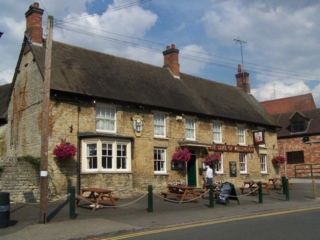
The Duke of Wellington Public House was formerly called the Cock Inn and was renamed between 1815 and 1821 in honour of Arthur Wellesley, 1st Duke of Wellington following the Battle of Waterloo on 18 June 1815.
An annual fundraising event for St Laurence church is organised by The Friends of Stanwick Church (FoSC) and starts with The Teddy Bear Parachute Jump where children's brave Teddy bears wearing parachutes are dropped from the top of the church. A volunteer rescue team is on hand, should any bear get into difficulties!
The Stanwick Races Event is held annually on Easter Monday and consists of a 10 km Road Race and a 2 km Fun Run. It is organised by volunteers from the village and the surrounding area. It includes participants from a number of countries in addition to semi-professionals and amateurs from the local area.
Services include Stanwick Club (a former Working Men's Club), The Duke of Wellington public house and a Village Shop incorporating the Post Office.
In 2006 Stanwick Lakes opened. It is a country park on the outskirts of the village, managed by the Rockingham Forest Trust on behalf of East Northamptonshire District Council. It comprises 750 acres (304 hectares) of former gravel pits and is part of the larger River Nene Regional Park. Located in close proximity to the country park is a selection of fishing lakes.
In 2009 the Parish Council purchased 10 acres (4 hectares) of land, now called the "Parish Fields", at the eastern end of the village that, when fully developed, will include a pocket park, wildflower meadow, recreation area and allotments.
In 2011 a new Village Hall was built in the village near to the church, replacing the old "Shant" and former British Legion Hall.
In 2012 The Post Office moved across the High Street to the site of The Old School (established by a Trust Deed in 1839). In the refurbished building there is also an enlarged shop, a cafe and a bistro.