
Elevation 205 m | Area 523 km² | |
 | ||
Time zone Myanmar Standard Time (UTC+6:30) | ||
Cheduba Island (Burmese: မာန်အောင်ကျွန်း; also known as Manaung Island) is an သisland in the Bay of Bengal close to Ramree Island and belongs to Myanmar, formerly Burma. It has a maximum length of 33 km (21 mi), with an area of approximately 523 km2 (202 sq mi)
Contents
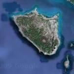
Map of Munaung, Myanmar (Burma)
Cheduba had a population of 63,761 as of 1983, composed chiefly of Burmese and Arakanese peoples. The main economic activities on the island are farming and cattle raising.
Geography
Cheduba Island lies about 10 km (6 mi) from the southwestern coast of Ramree Island. It is located between 18° 40′ and 18° 56′ N. lat., and between 93° 31′ and 93° 50′ E. long. The terrain of the island is quite flat with scattered moderate elevations. The highest point 205 metres (673 ft) is on a ridge in the southwestern part of the island.
There are 5 villages connected by a road that circles the island: Owa, Thitpon, Manaung, Budaunggwe, Sachet and Meinmangwe. There is an airfield west of Manaung, the main village of Cheduba, located on the northeast coast. Manaung is linked to the village of Kyaukpyu on nearby Ramree Island by steamer.
Most of the vegetation is tropical rainforest. There are mud cones that emit steam and sulfurous fumes on the island, which indicate some volcanic activity. There are also seepages of oil and gas.
Nearby islands
Other islands in the vicinity
History
Cheduba Island was a stop on the coastal trade route from Bengal by which Indian civilization migrated to Myanmar.
Historical records show that an earthquake of a magnitude of 8.5 to 9.0 hit off the western coast of Myanmar in April 1762, and reports speculated that a tsunami could kill more than one million people in Myanmar and Bangladesh. In 1881, a 7.9 magnitude earthquake in the Bay of Bengal caused "broad massive flames of fire" to be emitted on the island. In the 1780s, after the Burmese conquest of the area, Cheduba became a province of Arakan. Cheduba was captured in 1824 by the British, whose possession of it was confirmed in 1826 by the Treaty of Yandabo concluded with the Burmese. The island, along with many other islands in the area, was evacuated and occupied by the Japanese during World War II.