
Bathurst chaleur bay acadien cost drive
Chaleur Bay (in French, Baie des Chaleurs) - also known informally in English as Bay of Chaleur due to the influence of its French translation - is an arm of the Gulf of Saint Lawrence located between Quebec and New Brunswick.
Contents
- Bathurst chaleur bay acadien cost drive
- Chaleur bay
- GeographyEdit
- BeachesEdit
- RiversEdit
- IslandsEdit
- WeatherEdit
- FisheriesEdit
- Notable factsEdit
- References
The name of the bay is attributed to explorer Jacques Cartier (Baie des Chaleurs). It translates into English as "bay of warmth" or "bay of torrid weather".
Chaleur bay
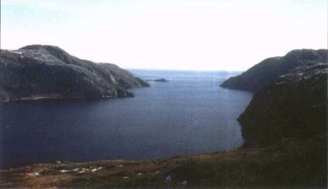
GeographyEdit
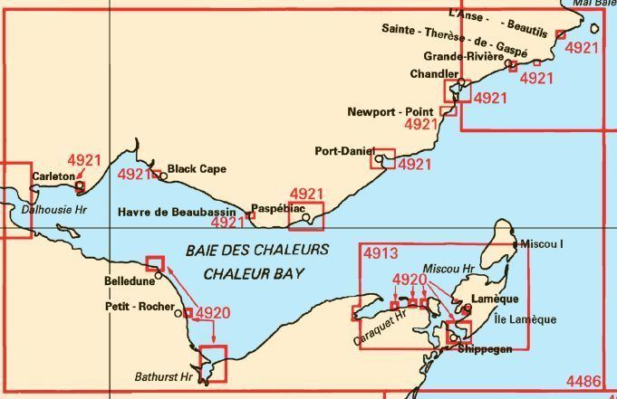
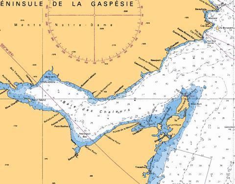
Chaleur Bay opens to the east with its southern shore formed by the north shore of New Brunswick. The northern shore is formed by the south shore of the Gaspé Peninsula. The bay measures approximately 50 km (27 nmi) in width at its widest point between Bathurst and New Carlisle. The western end of the bay transitions into the estuary of the Restigouche River at Dalhousie, New Brunswick.
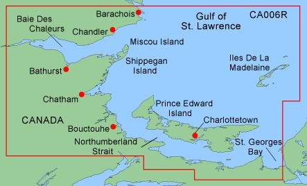
The mouth of the bay is delineated by a line running from "Haut-fond Leander" near Grande-Rivière, Quebec in the north and the "Miscou Shoals" near Miscou Island, New Brunswick in the south.
Canadian Hydrographic Service chart number 4486 is the bathymetric navigational data repository for the area.
BeachesEdit
The shores of Chaleur Bay include numerous beaches, particularly on the southern shore. Many rivers also form barachois or barrier beaches. Incorrectly claimed by locals as the world's second longest natural sand bar, the Eel River Bar, is a barrier beach located at the mouth of the Eel River immediately west of the village of Charlo, New Brunswick. This sand bar is unique not only because it has fresh water on one side and salt water on the next, but because it is home to the endangered piping plover.
Tourism in the region has been driven in the summer months by users of the bay's beaches. The warm ocean currents that enter the bay from the larger Gulf of St. Lawrence result in some of the warmest saltwater on the Atlantic coast north of the state of Virginia.
RiversEdit
The estuaries of various rivers emptying into the bay create a prominent smell of salt water, notably in the estuary of the Restigouche River.
The following major rivers flow into the bay:
New Brunswick (from north to south):
Between Quebec and New Brunswick:
IslandsEdit
Chaleur Bay has several islands. Although not entirely located within the bay, the northern shores of Miscou Island and Lameque Island form part of the southern shore of the bay. Heron Island lies near Dalhousie, New Brunswick and is located south of Carleton-sur-Mer, Quebec.
WeatherEdit
The bay's shape and the steep cliffs along its northern shore sometimes create particularly windy conditions especially off Nepisiguit Bay. Under the right wind direction and speed, sea conditions on large areas of the bay can become quite treacherous. Tidal currents are generally weak, except at the mouths of some rivers and certain channels. Its configuration tends to channel the wind for two reasons: the steep cliffs on its North side, and its V shape. This means that in the middle of this section, off Nepisiguit Bay, there is a zone that is particularly windy and subject to high seas if the wind is from the Northwest or the Northeast. Tidal currents in this section rarely reach one knot, except at the mouths of some rivers and some channels.
FisheriesEdit
Chaleur Bay is home to a variety of marine life including numerous species of ground fish and shellfish such as lobster and scallops.
Additionally, many of the bay's pristine rivers support some of the largest wild Atlantic Salmon remaining in the north Atlantic Ocean, creating a haven for sport angling.