
Country United States County Iron Incorporated February 18, 1868 Local time Monday 11:20 PM Area code 435 | State Utah Founded November 11, 1851 Elevation 1,782 m Population 29,162 (2013) | |
 | ||
Weather -3°C, Wind SE at 13 km/h, 48% Humidity | ||
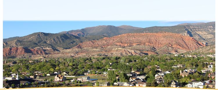
Cedar City is a city in Iron County, Utah, United States, 250 miles (400 km) south of Salt Lake City, and 180 miles (290 km) north of Las Vegas on Interstate 15. It is the home of Southern Utah University, the Utah Shakespeare Festival, the Utah Summer Games, the Neil Simon Theatre Festival, and other events. As of the 2010 census, the city had a total population of 28,857. In 2011, the U.S. Census Bureau estimated Cedar City's population to be 29,213.
Contents
Map of Cedar City, UT, USA
History
The presence of prehistoric people in the Cedar City area is revealed by rock art found in Parowan Gap to the north and Fremont sites dated to A.D. 1000 and 1300. Ancestors of the present-day southern Paiute Indians met the Dominguez–Escalante Expedition in this area in 1776. Fifty years later, in 1826, mountain man and fur trader Jedediah Smith traveled through the area exploring a route from Utah to California.
Cedar City was originally settled in late 1851 by Mormon pioneers originating from Parowan, Utah, who were sent to build an iron works. The site, known as "Fort Cedar" or "Cedar City," was equidistant from vast iron deposits 10 miles (16 km) west and coal resources 10 miles (16 km) up Cedar Canyon, but was named after the abundant local trees (which are actually Junipers instead of Cedar). Two companies of men led by Henry Lunt reached the fort site in a blizzard on November 11, 1851, making that date the official founding. In 1855, a new site, closer to the iron works and out of the flood plain of Coal Creek, was established at the suggestion of Brigham Young; present day Cedar City is located at this site. Cedar City was incorporated on February 18, 1868.
The iron works closed in 1858, though iron mining continued in the area until the 1980s. The completion of a railroad connection to Cedar City in 1923 established the area as a tourism gateway to nearby Bryce Canyon National Park, Zion National Park, and Grand Canyon National Park, in addition to Cedar Breaks National Monument. Cedar City continues to be a center of tourism, commercial development, education and the arts in southwestern Utah.
The city has shared in the rapid growth of much of Southwestern Utah since the late 1980s.
Geography and climate
Cedar City is located in the southeast Great Basin, and is about 20 miles (32 km) north of the northeastern edge of the Mojave Desert. Its elevation of 5,840 feet (1,780 m) gives it a cooler and less arid climate vis-à-vis nearby Dixie, but it retains its cultural ties to St. George—the two cities, for example, share a daily newspaper.
Cedar City is located at 37°40'57" North, 113°4'28" West (37.682606, -113.074402).
According to the United States Census Bureau, the city has a total area of 20.1 square miles (52 km2), none of which is covered with water.
The city is located on the western edge of the Markagunt Plateau, in a high desert valley, Cedar Valley, with no ocean drainage. The climate is the typical cool semi-arid climate (BSk) of the Mountain West, though snowfall can be quite heavy, reaching a historical maximum of 36.9 inches (0.94 m) in January 1949. Interstate 15 connects the city with St. George (50 miles) and Las Vegas (180 miles) to the south, and to Interstate 70 (70 miles) and Salt Lake City (250 miles) to the north. State roads connect Cedar City with Panaca, Nevada near US 93, Kanab, Utah via US-89, and to US 50 and US 6 in Nevada. Similar to St. George, the city enjoys an excellent location on the west's regional transportation network. Los Angeles is 439 miles (707 km) south and San Diego is 500 miles (800 km) south on Interstate 15, Phoenix is 465 miles (748 km) south via Interstate 15 and US-93, and Denver is 580 miles (930 km) east via Interstates 15 and 70.
A branch line of the Union Pacific Railroad serves customers on the western outskits of the city. The branch connects to the railway's main line at Lund.
Cedar City Regional Airport offers flights via Delta Connection.
Demographics
As of the census of 2000, there were 20,527 people, 6,486 households, and 4,682 families residing in the city. The population density was 1,021.8 people per square mile (394.5/km²). There were 7,109 housing units at an average density of 353.9 per square mile (136.6/km²). The racial makeup of the city was 92.06% White, 2.53% African American, 1.11% Native American, 0.47% Asian, 0.33% Pacific Islander, 1.65% from other races, and 1.86% from two or more races. Hispanic or Latino of any race were 4.14% of the population.
There were 6,486 households out of which 39.0% had children under the age of 18 living with them, 59.8% were married couples living together, 9.1% had a female householder with no husband present, and 27.8% were non-families. 16.3% of all households were made up of individuals and 5.8% had someone living alone who is 65 years of age or older. The average household size was 3.07 and the average family size was 3.37.
In the city, the population was spread out with 28.2% under the age of 18, 27.4% from 18 to 24, 22.6% from 25 to 44, 14.0% from 45 to 64, and 7.8% who were 65 years of age or older. The median age was 23 years. For every 100 females there were 95.6 males. For every 100 females age 18 and over, there were 91.0 males..
The median income for a household in the city was $32,403, and the median income for a family was $37,509. Males had a median income of $31,192 versus $19,601 for females. The per capita income for the city was $14,057. About 14.5% of the families and 22.1% of the population were below the poverty line, including 20.2% of those under the age of 18 and 4.2% of those 65 and older.
Economy
The economy is mostly centered on a small manufacturing hub, tourism, and home construction.