
Named for Iron mines Website www.ironcounty.net Founded 1852 | Area 8,550 km² Population 46,780 (2013) | |
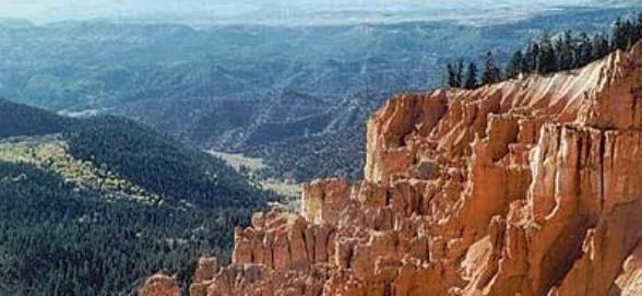 | ||
Points of interest Cedar Breaks National, Frontier Homestead State Par, Brian Head Ski Resort, Brian Head Peak, Red Canyon Trailhead Colleges and Universities Southern Utah University, Southwest Applied Technolo, Evans' Hairstyling College, George Wythe University | ||
Iron County is a county located in the U.S. state of Utah. As of the 2010 census, the population was 46,163. Its county seat is Parowan, and the largest city is Cedar City. The county was created in 1850 and organized the following year. It was originally named Little Salt Lake Valley, and renamed for the iron mines west of Cedar City.
Contents
- Map of Iron County UT USA
- Geography
- Adjacent counties
- National protected areas
- Demographics
- Recreation
- References
Map of Iron County, UT, USA
The Cedar City, UT Micropolitan Statistical Area includes all of Iron County.
Geography
According to the U.S. Census Bureau, the county has a total area of 3,301 square miles (8,550 km2), of which 3,297 square miles (8,540 km2) is land and 4.4 square miles (11 km2) (0.1%) is water. A small part of Zion National Park extends northward into the county, near Kanarraville. Cedar Breaks National Monument is located entirely within the county, near its southeastern corner.
Adjacent counties
National protected areas
Demographics
As of the census of 2000, there were 33,779 people, 10,627 households, and 8,076 families residing in the county. The population density was 10 people per square mile (4/km²). There were 13,618 housing units at an average density of 4 per square mile (2/km²). The racial makeup of the county was 93.00% White, 0.35% Black or African American, 2.18% Native American, 0.74% Asian, 0.27% Pacific Islander, 1.78% from other races, and 1.67% from two or more races. 4.09% of the population were Hispanic or Latino of any race. The top 5 Ethnic groups in Iron County are:
There were 10,627 households out of which 41.00% had children under the age of 18 living with them, 64.20% were married couples living together, 8.50% had a female householder with no husband present, and 24.00% were non-families. 15.90% of all households were made up of individuals and 5.90% had someone living alone who was 65 years of age or older. The average household size was 3.11 and the average family size was 3.45.
In the county, the population was spread out with 31.20% under the age of 18, 20.60% from 18 to 24, 23.60% from 25 to 44, 16.10% from 45 to 64, and 8.60% who were 65 years of age or older. The median age was 24 years. For every 100 females there were 98.40 males. For every 100 females age 18 and over, there were 93.60 males.
The median income for a household in the county was $33,114, and the median income for a family was $37,171. Males had a median income of $30,800 versus $19,831 for females. The per capita income for the county was $13,568. About 13.10% of families and 19.20% of the population were below the poverty line, including 20.40% of those under age 18 and 6.50% of those age 65 or over.
Recreation
A recreation area located in a pine/aspen forest with hiking, fishing, picnic areas, a volleyball court and restroom facilities.
A recreation area made up of volcanic rock and hills. The area features rock climbing, picnics, fishing, off-road vehicle use and bike riding.