
Country Region Founded December 26, 1878 | Area 129.10 km2 District 2nd district of Quezon Mayor Ferdinand Maliwanag | |
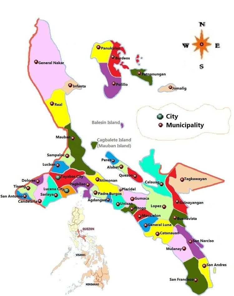 | ||
Map of Candelaria, Quezon
Candelaria, officially as the Municipality of Candelaria (Filipino: Bayan ng Candelaria) is a first class Municipality in the Province of Quezon, Philippines. According to the 2015 census, it has a population of 117,434 people. making the third most populous in the province of Quezon
Contents
- Map of Candelaria Quezon
- Candelaria quezon candle festival 2008 st dancing 6 of 10
- Candelaria quezon shop lifter syndicate with picture trinity school and office supplies
- Foundation
- American era and Japanese occupation
- Geography
- Barangays
- Climate
- Topography
- Demographics
- Language
- Economy
- Places of interest
- Candle festival
- Local government
- Road network
- Public transport
- Water transport
- Air transport
- Communications
- Health care
- Secondary
- Tertiary
- References
Candelaria is the second largest industrial center of the province, after Lucena City. Among the municipalities in Quezon Province, Candelaria has the most desiccated coconut factories and oil refineries, such as Peter Paul Philippine Corporation, Primex Coco Products Inc., Pacific Royal Basic Foods, SuperStar Corporation, Tongsan Industrial Development Corporation, and others, which employ thousands of people.

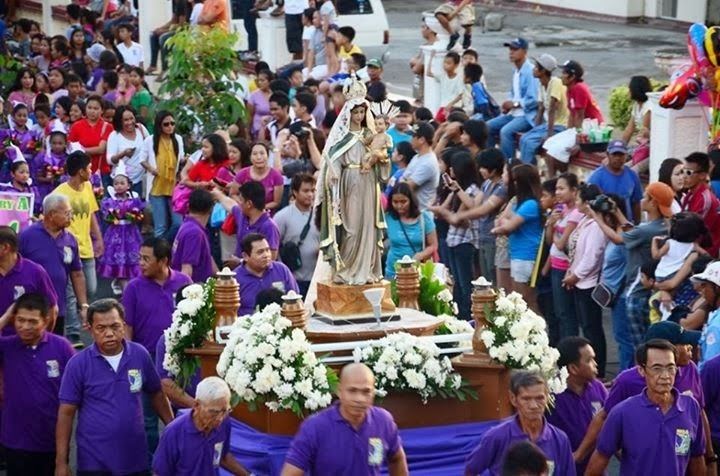
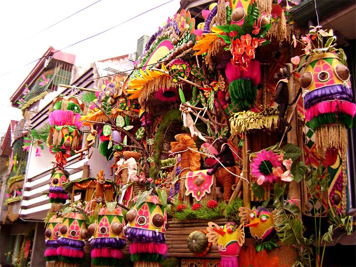
Candelaria quezon candle festival 2008 st dancing 6 of 10
Candelaria quezon shop lifter syndicate with picture trinity school and office supplies
Foundation
Prior to 1885, the pioneering barangays of Candelaria in its Western part notably, Taguan, Kinatihan and Masin were parts of the Municipality of Tiaong, while Malabanban, Mangilag and Sta. Catalina in the East, were under the jurisdiction of the town of Sariaya.
It was on December 26, 1878, that a permit was granted by the Governor General of the Philippine Islands for the establishment of an independent government over these Barangays. Its boundaries were fixed by means of a treaty signed by the notable leaders of Tiaong, Sariaya and the founding families of Candelaria.
The King of Spain, His Majesty Alfonso XII, finally approved the establishment of Candelaria as an independent town on August 5, 1879.
American era and Japanese occupation
In 1902, after the cessation of the general hostilities against the Americans, administration of Candelaria was merged with the neighboring town of Sariaya. In 1908, after less than seven years, Candelaria was again managed independently, as a fourth-class municipality. During the American regime, the town progressed by leaps and bounds. Many houses and public edifices were constructed, and commerce and industries grew, until the Japanese invasion brought a further wave of destruction.
Geography
The municipality lies at the western arm of Quezon Province, about 107 kilometers from Manila and 23 kilometers from Lucena City. At its northern part lies the famous Mount Banahaw, on the east is the town of Sariaya, on the south is San Juan, Batangas, and on the west are Dolores and Tiaong. The neighboring cities are Lucena, Tayabas, San Pablo and Lipa City. It is traversed by the Pan Philippine Highway and the Philippine National Railways.
Candelaria has an area of about 12,910 hectares, an agricultural municipality, and is situated in the southern slope of Mount Banahaw. The town proper is wedged by two rivers, namely, Masin River on the west and Quiapo River on the east.
Barangays
Candelaria is politically subdivided into 25 barangays, listed here with their respective Barangay Captains and population as of 2015:
Climate
There are two pronounced seasons in Candelaria: Dry and hot season from March to May, Wet season for the rest of the year. Typhoons often struck the municipality. The most remarkable are Supertyphoon "Rosing" in November 1995 and Typhoon "Milenyo" in September 2006.
Normal temperatures in Candelaria range from 22 °C (72 °F) to 32 °C (90 °F). It is slightly warmer than the more elevated municipality of Lucban and Sampaloc. The temperatures became cooler in January with a range of about 18 °C (64 °F), while in April, the hottest month, may rise of up to 35 °C (95 °F).
Topography
Candelaria is more elevated in the northern part since it lies at the southern slope of Banahaw and predominantly agricultural. There are plantations of coconut and vegetables in its remote barangays. Most of the inhabitants are having poultry and livestock business and in the remaining part of the municipality are farmlands mostly of rice, corn, and other root crops.
Demographics
Candelaria has a population of 117,434 as of the 2015 census. The increase in population became rapid in the 1990s, in 1995, it has a population of 80,733 inhabitants, while in 2000, the population grew to 92,429, with an increase of about 15 percent.
In 2007, the official number of inhabitants in the municipality based on 2007 census is 105,997, or about 4,240 families or 21,243 Households. Most Candelarians reside in Pahinga Norte and Malabanban Norte, the adjacent barangays of the town proper.
As of 2007, almost 93 percent of the population are Roman Catholics, 3.5 percent are Protestants, about 3 percent are members of Iglesia ni Cristo, 0.05 percent are of Islam, 0.97 percent are of other denominations such as Pentecostalists, Fundamental Baptist, Bible Baptist, Conservative Baptist, Latter Day Saints, Seventh Day Adventist, Jehovah's Witnesses and others.
Language
Tagalog is widely spoken by the populace. However, their accent resembles the Tagalog dialect spoken in Batangas owing to its location, and history. Most of Candelarians came from the neighboring province of Batangas.
Economy
Candelaria is one of the most progressive municipalities in Quezon Province. Rapid progress have been felt since the 1990s where most of the commercial establishments have been built such as retail merchandising, grocery, hardware, fastfood outlets, shopping center, and others. The Candelaria Public Market, though it is adjacent to Barangay Poblacion, is located on Barangay Pahinga Norte.
Places of interest
Candle festival
The town fiesta is celebrated on the 5th of February to honor the patron saint San Pedro Bautista. Since 2005, Monsignor Carlos (Charles) Pedro A. Herrera, the parish priest, started his devotion to Nuestra Senora de Candelaria and honored her with a Candle Festival every February 2. The celebration was concluded with a procession through the streets of the town featuring the street dancing by the youth of the community in honor of the Blessed Virgin. A parade of floats representing each of the 25 barangays was, also, featured during the festivities.
A project in honor of the Blessed Mother Mary that will renovate the patio of the San Pedro Bautista Parish Church had been developed on April 22, 2012. The renovated patio will convert the current parking lot into a multi-purpose open amphitheater for use of the people of Candelaria. It will provide a venue for children and toddlers playground, jogging/walking path, a rosary garden, a via Dolorosa, and a stage for performances complete with controlled theater lighting. The playground will be lit with lighting standards. The fundraising for the project will be accomplished through a 1000 Points of Light campaign where each point of light will be represented by a Candelarian or friends of Candelaria contributing Php5000 or more. Inauguration is scheduled for February 2, 2013, CANDLE FESTIVAL celebration. Ground breaking is targeted for August 4, 2012, ARAW NG CANDELARIA. The community project is expecting every Candelarians around the world to step up and bring their "POINT OF LIGHT". The SPBPC parish council for economic affairs is taking the lead with Dr. Al Cornejo at the helm.
Local government
Elected officials (2016-2019):
Road network
There are three major highways that pass throughout the municipality and the town proper. The South Luzon Expressway Toll Road 4 (TR4) stretching from Sto. Tomas, Batangas to Lucena City will pass in the northern part of the municipality, planned to be finished in 2016. The new expressway will occupy portions of Barangays Bukal Norte, Masalukot II, Masalukot I, Mayabobo, and Mangilag Norte. However, these matters are only speculations at present and not yet confirmed.
There are also major roads within the municipality.
Public transport
Provincial Buses to and from Metro Manila and Lucena City such as JAC Liner Inc., DLTBCO, JAM Liner and Lucena Lines stops at the municipality's designated bus stop located in Poblacion for passengers.
There are also jeepney terminals located in the town proper. For passengers going to Lucena City, the terminal is located in Rizal Avenue corner Gonzales Street in front of Bank of the Philippine Islands branch. For passengers going to San Pablo City, the terminal is located beside Metrobank in Rizal Avenue corner Del Valle Street. For passengers going to San Juan, Batangas the terminal is located in Gonzales Street.
Tricycles are the most common mode of transportation in the municipality. There are lots of tricycle terminals in Barangay Poblacion, serving local commuters to the nearby barangays.
Water transport
Candelaria has no coastline and one of the inland municipalities of Quezon Province, together with Dolores, Lucban, Sampaloc, San Antonio, Tayabas, and Tiaong. The seaport nearest to the municipality is Dalahican Port in Lucena City for passengers going to Marinduque, Masbate, and other island provinces. Dalahican Port is about 30 kilometers from Candelaria. Subuquin Port in San Juan, Batangas is also a consideration. Among the international seaports in Luzon, Batangas Port in Batangas City is the nearest one. It would take approximately two hours in a private vehicle to reach from Candelaria, passing through the municipalities of San Juan, Rosario, and Ibaan, Batangas.
Air transport
Candelaria has no airport, runway or any facility to accommodate air operations. The nearest airbase in the municipality is the San Fernando Airbase in Lipa City with a distance of about 32 kilometers west of the municipality, while the nearest international airport is the Ninoy Aquino International Airport in Pasay City with a distance of about 103 kilometers north-west of the municipality. For air travelers, you have to travel for more or less two hours to reach Metro Manila and a couple of minutes more for Ninoy Aquino International Airport in case of traffic obstructions.
Communications
Candelaria's telecommunications needs are met by General Telephone System, Inc. (GTSi) and Digitel Telecommunications (PLDT-Digitel), which are the primary service providers in the area. GTSi commenced its operations in the municipality in 1981, marking Candelaria as the third location of its expansion, following its initiation in Gumaca in 1977 and Atimonan in 1979.
Internet shops are commonly found in the town proper.
Health care
Candelaria has three hospitals: one public and two private.
The Candelaria Municipal Hospital is built during the administration of then Mayor Pedro Cedeno in 1984. Peter Paul Medical Center is one of the pioneering hospitals of the municipality, established in 1948. United Candelaria Doctors Hospital is the newly built medical facility of Candelaria, opened in February 2009.
Each barangay has its own health center for free health services. More lying-in clinics are located throughout the municipality.