
La m moire du canal de marseille
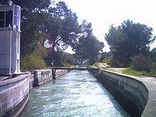
The Canal de Marseille is a major source of drinking water for the city of Marseille, the largest city in Provence, France. The canal's length along its main artery is 80 kilometres (50 mi) - though there is an additional 160 kilometres (99 mi) of minor arteries - and it services the entire district of Marseille. It took fifteen years of construction under the direction of the engineer Franz Mayor de Montricher, and was opened on July 8, 1849. It represents a significant achievement in nineteenth century engineering, combining bridges, tunnels, and reservoirs to create a canal over mountainous terrain. Until 1970, it was almost the sole water source for Marseille and currently provides two-thirds of the city's drinking water.
Contents
- La m moire du canal de marseille
- Le canal de marseille fait peu neuve
- HistoryEdit
- ConstructionEdit
- Through the Bouches du RhoneEdit
- Water QualityEdit
- AdministrationEdit
- Support and maintenanceEdit
- SecurityEdit
- As tourist site and cultural attractionEdit
- Marcel PagnolEdit
- References
Le canal de marseille fait peu neuve
HistoryEdit
Marseille, located along the hilly Mediterranean seafront is only crossed by one irregular river, the Huveaune River, and its tributary, the Jarret River. The waters were canalized in the 14th century, but over time became an open sewer. Water quality continued to decline and the distribution suffered due to lack of maintenance on the network.
Further, since the river suffered from a weak flow droughts were devastating to the region. For example, in 1834 the river nearly dried out completely and only 1 litre (1 US qt) was available per person, per day. In the 1830s, Marseille began to experience rapid population growth and in 1832-1835 epidemics of cholera convinced elected officials to act to restore health and ensure an appropriate quantity of water for the city.
This cholera epidemic caused the deaths of approximately 100,000 people throughout France. Originally of Asian origin, the disease spread along the Ganges valley in 1826, then the Caspian and Volga in 1829. In 1830, the disease overtook Moscow and Poland, and Hamburg in 1831. In March 1832, cholera reached Paris, where 18,000 died, and decimated the population in Haute-Provence. In July 1833, the epidemic reached Marseille. By December 1834, 865 were dead and in 1835 the death toll numbered 2,500.
These epidemics revived the residents' fears of the Great Plague of Marseille, which had occurred a little more than a century before and caused around 100,000 deaths. In July 1833, 30,000 Marseillaise gathered in the city center to protest the sanitary conditions.
Maximin-Dominica Consolat, mayor of Marseille from 1832 to 1843, decided in 1834 to improve conditions, "no matter what it costs." The decision was made to bring in water from the nearest large river, the Durance. However, the distance was substantial and the river was separated from Marseille by mountain chains (chaîne des Côtes, plateau de l'Arbois, massif de l'Étoile). The plan called for water to be captured quite high on the Durance and thus harness gravity to overcome the mountainous terrain and arrive in Marseille at the highest point of the city, Saint-Antoine (150 metres (492 ft)). Hence allowing water service to the entire community.
ConstructionEdit
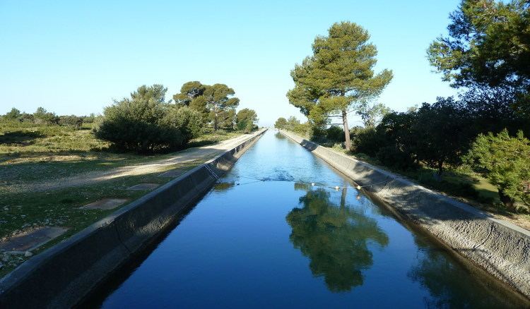
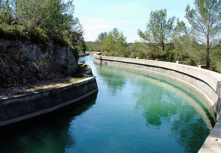
The building of the canal took 15 years, from 1839–1854 and covered 80 kilometres (50 mi) of which 17 kilometres (11 mi) were underground. The canal also traverses 18 bridges.
Indeed, a major challenge faced was passing the canal over the valley of the Arc, which has an altitude of less than 100 metres (328 ft) between Aix-en-Provence and the Etang de Berre. The project's chief engineer, Franz Mayor de Montricher, rejected the proposal of a bridge-trap and decided instead to build an aqueduct where the escarpments on either side of the valley were closest at 400 metres (1,312 ft): this would become the Roquefavour Aqueduct at Ventabren, inspired by the Roman architectural work Pont du Gard. Since then, the Roquefavour Aqueduct, which is 393 metres (1,289 ft) long, has been regarded as one of the main tourist attractions of the Aix-en-Provence region.
The canal is mostly constructed of concrete, although some portions are created from stone or brick. The canal's flow is 10 cubic metres (10 kl) per second, the slope is .36 metres (1.2 ft) per 1 kilometre (0.62 mi). The width at the top is 9.4 metres (31 ft), and the width at the basin is 3 metres (10 ft).
Water began flowing through the partially unfinished canal on November 19, 1849 in Marseille. Between 1854 and 1869, 77 kilometres (48 mi) of pipes, tanks, and basins were constructed, allowing access to water throughout Marseille and the neighboring communes of Plan-de-Cuques, Allauch, and Aubagne.
Despite the doubling of the population in the next forty years, Marseille in 1876 had over thirty times more water per capita: 370 litres (98 US gal) for domestic usage and 660 litres (174 US gal) for industrial activities, daily.
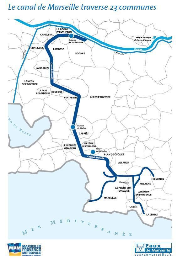
Through the Bouches-du-RhoneEdit
The initial intake of the canal from the Durance was at the bridge "Pertuis" in the Vaucluse at an elevation of 185 metres (607 ft) and 50 kilometres (31 mi) from Marseille. From there, the canal travels west to Lew Puy-Sainte-Réparade, then northwest to Saint-Estève-Janson. Then the canal continues north-west to the bridge Cadenet, where it feeds the pondSt. Christopher.
The route then clings to the hills, passes over La Roque-d'Anthéron and Charleval, and then exits the Durance and EDF, turns to the south and enters a long tunnel under the west end of the chaîne des Côtes, a mountain range.
After Lambesc, the canal's path becomes more complex: many bridges and tunnels are required to travel the valleys and near Coudoux. The canal travels around the hill of Ventabren, and comes to the River Arc, where it enters the Roquefavour Aqueduct. Near this area, the Paris-Marseille high speed railway line passes it, and the railway bridge structure has been designed to harmonize with the aqueduct.
A 3 kilometres (2 mi) tunnel crosses under the southern Arbois plain until the canal enters the treatment plant Giraudets. Finally, the water flows into a 2 kilometres (1 mi) entrance lead into Marseille.
Water QualityEdit
Today, the canal is no longer the sole water source for Marseille. The Canal de Provence, an almost completely underground network of canals from the Verdon River built in the 1970s now brings water to not only Marseille, but also Aix-en-Provence and Toulon. Today, this water amounts for approximately two-thirds of the water brought into Marseille, the remaining third comes from the Verdon through Provence. Both sources are interconnected.
The water is treated in two water treatment facilities, Sainte-Marthe and Saint-Barnabé. The main operations performed by the treatment facilities are pre-chlorination, clarification by flocculation with a coagulant, sand filtration and disinfection with ozone and chlorine. In 2006 the health authority of Marseille carried out a number of tests on the water quality determining that the canal's water conformed to all required norms. In 2009 a young mother & her baby where found dead in their apartment: the culprit was chlorine gas from the water supply. This led to a city-wide survey of the gasses in system, although not before others where admitted to hospital from all over the city.
AdministrationEdit
The canal was operated by the city of Marseille from 1849 to 1941. However, following the destructive fire of the "Nouvelles Galeries"'store November 1938, in which 73 people died, the city government was put under trusteeship, and due to this, the operation of the canal was entrusted to the Société d’études des eaux de Marseille (SEEM) (English: Society for the study of the Marseille Water) and Raoul Dautry, who had assisted in the creation of the SNCF was named the first president.
Since then SEEM, held equally by Veolia Environnement and Lyonnais des eaux, has controlled the canal's operation.
Support and maintenanceEdit
Upon entering the treatment facility at Sainte-Marthe in the 14th arrondissement, the canal water is filtered at the le bassin du Merlan before exiting the structure to enter the distribution network of Marseille. However, the canal does not only serve sanitary purposes. Historically, the structure assisted in irrigating fields for farmers and gardeners and greatly boosted the growth of gardening in the district.
The canal's offshoot irrigation ditches are controlled by the aygadiers, who have the right to cross private property in order to assist in the repair and operation of the canal. The focus of SEEM and the aygadiers has recently been on centring the use of the canal on drinking water. Therefore, irrigation rights are not being renewed and the municipality is providing pressured-water instead.
Furthermore, the canal authority employs 15 chercheurs de fuite (French: literally "searchers of leaks") who are responsible for finding leaks in the distribution system. As assistance, the chercheurs utilize geophones which amply sound up to 400 times. These employees have allowed the efficiency of the canal to raise to 85%.
SecurityEdit
The canal outside of Marseille proper is open to the air and can be followed along the road, except for the subterranean portions. However, within the city limits, efforts are being made to cover the canal, prompted by safety concerns over the unpredictable nature of the water's flow following valve openings and the steep and slippery walls. In addition, there are ongoing campaigns aimed at adding fences, lifelines, and barriers, and posting warning signs along the canal's route
As tourist site and cultural attractionEdit
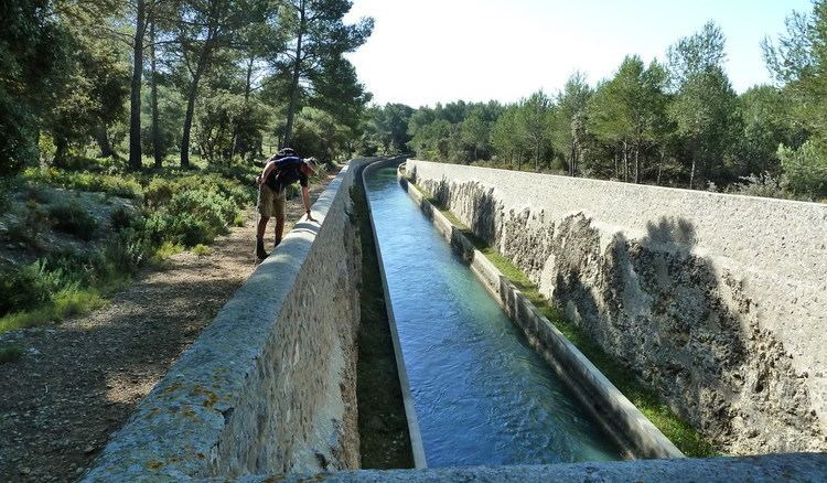
The canal passes through many picturesque regions of Provence and contains bicycle and walking paths along its route.
Notable remarkable sites include:
Marcel PagnolEdit
French novelist Marcel Pagnol refers to the canal in his memoirs, Le Château de ma mère, where his father is given a key which enables him to enter the canal through private property and thus shorten his journey. However, the truth of this claim is doubted.