
Native name L'Huveaune (f) Basin size 500 km (190 sq mi) Length 48 km | Discharge 10 m³/s Basin area 500 km² Mouth Mediterranean Sea | |
 | ||
Main source Sainte-Baume590 m (1,940 ft) Similar Sainte‑Baume, Garlaban, Parc Borély, Plages du Prado, Calanque | ||
The Huveaune (Occitan: Uveuna) is a small river in the Provence-Alpes-Côte d'Azur region of southeastern France. It is 48.4 kilometres (30.1 mi) long and flows through the communes of La Penne-sur-Huveaune, Nans-les-Pins, Saint-Zacharie, Plan-d'Aups-Sainte-Baume, Auriol, Roquevaire, Aubagne, and the metropolitan area of Marseille.
Map of L'Huveaune, France
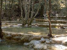
The Huveaune rises in the Castelette cave at 590 metres (1,940 ft) in the Sainte-Baume mountain range, and discharges into the Mediterranean Sea at Marseille.
References
Huveaune Wikipedia(Text) CC BY-SA