
Country United States FIPS code 16-12520 Elevation 811 m Population 315 (2013) Area code 208 | Time zone Mountain (MST) (UTC-7) GNIS feature ID 0400338 Zip code 83610 Local time Tuesday 12:30 AM | |
 | ||
Weather -4°C, Wind NW at 6 km/h, 82% Humidity Area 127 ha (124 ha Land / 3 ha Water) | ||
Farm dronie in cambridge idaho
Cambridge is a city in Washington County, Idaho, United States. The population was 328 at the 2010 census, down from 360 in 2000. It is the second largest city in the county, behind the significantly larger Weiser, the county seat.
Contents
- Farm dronie in cambridge idaho
- Map of Cambridge ID 83610 USA
- Walk around cambridge idaho small village buried in snow
- Geography
- Climate
- 2010 census
- 2000 census
- Notable people
- Highways
- References
Map of Cambridge, ID 83610, USA
Walk around cambridge idaho small village buried in snow
Geography
Cambridge is located at 44°34′18″N 116°40′41″W (44.571535, −116.678013), at an elevation of 2,661 feet (811 m) above sea level. According to the United States Census Bureau, the city has a total area of 0.49 square miles (1.27 km2), of which, 0.48 square miles (1.24 km2) is land and 0.01 square miles (0.03 km2) is water.
Climate
Cambridge has a dry-summer continental climate (Köppen Dsa), with cold, moist winters, gradual springs, hot and dry summers, and brief autumns. July is the hottest month, with a daily average of 74.1 °F (23.4 °C); highs reach 100 °F (38 °C) on 10.7 days in a typical year and 90 °F (32 °C) on 57 days. Yet because of the aridity, summer nights typically cool to below 60 °F (16 °C). January is the coldest month, with a daily average of 23.3 °F (−4.8 °C), and lows falling to 0 °F (−18 °C) or below on 9.6 nights per year. Snowfall averages 33 inches (84 cm) per season. Precipitation is usually infrequent and light, especially so during the summer months. Extremes have ranged from −35 °F (−37 °C) on December 13, 1919 to 117 °F (47 °C), recorded July 29, 1934.
2010 census
As of the census of 2010, there were 328 people, 151 households, and 100 families residing in the city. The population density was 683.3 inhabitants per square mile (263.8/km2). There were 178 housing units at an average density of 370.8 per square mile (143.2/km2). The racial makeup of the city was 98.2% White, 0.6% Native American, and 1.2% from two or more races. Hispanic or Latino of any race were 0.3% of the population.
There were 151 households of which 25.2% had children under the age of 18 living with them, 52.3% were married couples living together, 8.6% had a female householder with no husband present, 5.3% had a male householder with no wife present, and 33.8% were non-families. 33.1% of all households were made up of individuals and 14.5% had someone living alone who was 65 years of age or older. The average household size was 2.17 and the average family size was 2.68.
The median age in the city was 47.1 years. 21.6% of residents were under the age of 18; 5.9% were between the ages of 18 and 24; 20.2% were from 25 to 44; 29.5% were from 45 to 64; and 22.9% were 65 years of age or older. The gender makeup of the city was 50.0% male and 50.0% female.
2000 census
As of the census of 2000, there were 360 people, 152 households, and 100 families residing in the city. The population density was 1,270.6 people per square mile (496.4/km²). There were 173 housing units at an average density of 610.6 per square mile (238.6/km²). The racial makeup of the city was 98.33% White, 0.28% Native American, 0.83% from other races, and 0.56% from two or more races.
There were 152 households out of which 24.3% had children under the age of 18 living with them, 55.9% were married couples living together, 7.9% had a female householder with no husband present, and 33.6% were non-families. 30.9% of all households were made up of individuals and 13.8% had someone living alone who was 65 years of age or older. The average household size was 2.37 and the average family size was 2.97.
In the city, the population was spread out with 24.2% under the age of 18, 5.6% from 18 to 24, 20.3% from 25 to 44, 28.3% from 45 to 64, and 21.7% who were 65 years of age or older. The median age was 45 years. For every 100 females there were 96.7 males. For every 100 females age 18 and over, there were 85.7 males.
The median income for a household in the city was $22,386, and the median income for a family was $31,111. Males had a median income of $25,000 versus $15,000 for females. The per capita income for the city was $14,475. About 7.8% of families and 10.9% of the population were below the poverty line, including 12.9% of those under age 18 and 7.0% of those age 65 or over.
Notable people
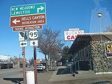
Highways
The city is served by U.S. Highway 95, connecting to Council and New Meadows to the north and Weiser and Payette to the south. State Highway 71 heads northwest from Cambridge to the Brownlee Dam on the Snake River.