
Official name Brownlee Dam Creates Brownlee Reservoir Opened 1959 | Height 128 m Total capacity 1.76 km³ Construction began 1955 | |
 | ||
Opening date May 9, 1958 (1958-05-09) 59 years ago Catchment area 72,590 square miles (188,000 km) Similar | ||
From cambridge to brownlee dam idaho part 1
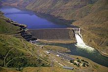
Brownlee Dam is a hydroelectric earth fill embankment dam in the western United States, on the Snake River on the Idaho-Oregon border, In Hells Canyon at river mile 285, it impounds the Snake River in the 58-mile (93 km)-long Brownlee Reservoir.
Contents
- From cambridge to brownlee dam idaho part 1
- Map of Brownlee Dam Cambridge ID 83610 USA
- HeliportEdit
- References
Map of Brownlee Dam, Cambridge, ID 83610, USA
It is part of the Hells Canyon Project that also includes Hells Canyon Dam and Oxbow Dam, built and operated by Idaho Power Company. The first and upper-most of the three dams, its contractor was Morrison-Knudsen of Boise. It started filling on May 9, 1958 (1958-05-09), 59 years ago.
The dam's powerhouse contains five generating units with a total nameplate capacity of 585.4 megawatts.
Lacking passage for migrating salmon, the three Hells Canyon Project dams blocked access by anadromous salmonids to a stretch of the Snake River drainage basin from Hells Canyon Dam up to Shoshone Falls, which naturally prevents any upstream fish passage to the upper Snake River basin.
HeliportEdit
There is a 100-by-60-foot (30 by 18 m) private heliport, Brownlee Heliport, (FAA LID: OR75) located near the dam.