
West end: SR 1 near Albion Length 194 km | ||
 | ||
California state route 128 october 22 2013
State Route 128 (SR 128) is a state highway in the U.S. state of California, connecting the Mendocino coast to the Central Valley through the state's Wine Country.
Contents
- California state route 128 october 22 2013
- Map of CA 128 California USA
- Route description
- History
- Major intersections
- References
Map of CA-128, California, USA
Route description
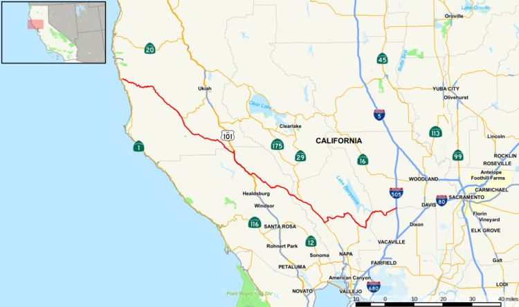
Route 128 begins at Route 1 near the mouth of the Navarro River at the Pacific Ocean. The highway travels upriver through the coast redwood forests of Navarro River Redwoods State Park and through the vineyards and apple orchards of the Anderson Valley to Boonville. Route 253 terminates into Route 128 at the south end of Boonville. Leaving Boonville, Route 128 climbs out of the Navarro River watershed and crosses the Yorkville Highlands before descending into the Russian River watershed, arriving at Cloverdale in the Alexander Valley, where the highway joins U.S. Route 101 heading south. A few miles later, at Geyserville, Route 128 separates from U.S. 101 and crosses Knights Valley on the way to Napa Valley, where it joins Route 29 at Calistoga. After passing through the town of St. Helena, Route 128 splits from Route 29 at Rutherford and climbs east over dry ridges above Lake Berryessa to the Sacramento Valley. In Winters, the route's constructed portion ends at Interstate 505. By its legal definition, the route continues 14 mi (23 km) east to Route 113 at Davis and Interstate 80, but this segment is currently not constructed.
The section of Route 128 through Navarro River Redwoods State Park is often closed in winter storms due to flooding. Two slower alternate routes are available: the Philo-Greenwood road connects Route 1 near Elk to Route 128 near Hendy Woods State Park, a few miles north of Philo; another alternate route is the Comptche-Ukiah Road, which intersects Route 1 just south of the town of Mendocino and runs inland to Comptche, and departs Comptche on Flynn Creek Road, intersecting Route 128 just up river from the seasonal flood gate closing the highway.
History
The main road through the Anderson Valley to the mouth of the Navarro River, and from there up the coast to Fort Bragg, was originally called the Navarro Highway; it follows the approximate route of the present Route 128 and Route 1 through Mendocino County. Even earlier, the road followed the Navarro Ridge, to the north of the present alignment, instead of staying at the river level. By 1938, the last stretches of old winding roadway near the present location of Navarro were replaced by a straighter alignment, taken over from a disused logging railway line.
Before being numbered as California State Route 128, the highway was signed as State Route 28. In 1952 it was renumbered State Route 128, permitting a different highway around Lake Tahoe to be numbered as Route 28 to coordinate its numbering with Nevada Route 28.
Major intersections
Except where prefixed with a letter, postmiles were measured on the road as it was in 1964, based on the alignment that existed at the time, and do not necessarily reflect current mileage. R reflects a realignment in the route since then, M indicates a second realignment, L refers an overlap due to a correction or change, and T indicates postmiles classified as temporary (for a full list of prefixes, see the list of postmile definitions). Segments that remain unconstructed or have been relinquished to local control may be omitted. The numbers reset at county lines; the start and end postmiles in each county are given in the county column.