
Peak Sacagawea Peak | Elevation 9,665 ft (2,946 m) | |
 | ||
Similar Bridger Bowl Ski Area, Rocky Mountains, Tobacco Root Mountains, Hyalite Canyon Road, Bozeman Pass | ||
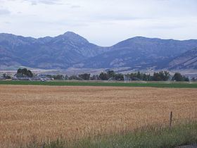
The Bridger Range (highest point: Sacagawea Peak 9,665 feet (2,946 m)), also known as the Bridger Mountains, is a subrange of the Rocky Mountains, in southwestern Montana in the United States. The range runs mostly in a north - south direction between Bozeman and Maudlow. It is separated from the Gallatin Range to the south by the Bozeman Pass; the Horseshoe Hills to the west by Dry Creek; the Crazy Mountains to the east by the Shields River valley; and the Big Belt Mountains to the north by Sixteen Mile Creek. The Bozeman Pass, el. 5,712 feet (1,741 m), is a narrow pass that lies between Bozeman and Livingston. Sacagawea Peak is a prominent peak visible to the northeast from Bozeman. The entire range is within Gallatin National Forest. Although the range is for the most part in Gallatin County a small portion of the range extends into Park County, Montana.
Contents
Map of Bridger Range, Montana 59714, USA
HistoryEdit
The range is named after Jim Bridger, who pioneered the Bridger Trail through mountains in southern Wyoming into the Bighorn Basin in 1864.
On January 10, 1938, Northwest Airlines Flight 2 crashed in the Bridger Mountains, killing all 10 aboard. This was the first fatal crash of a Northwest Airlines aircraft.
Prominent peaksEdit
The most prominent peaks in the Bridgers include:
SkiingEdit
The Bridger Range is also home to ski area Bridger Bowl. With the first rope tow installed in 1951, Bridger Bowl became a primarily locals mountain, the area has a top elevation of 8700 ft and a base elevation of 6100 ft. On average the ski area receives 350 inches of snow every year. Backcountry skiing is also very popular with snow being available on peaks such as Sacagawea from early November until late May/early June. Beginning the 2008-2009 ski season, Bridger Bowl started to allow backcountry travel from the ski area via access gates on the northern and southern boundaries.
HikingEdit
Though many hiking trails exist, Sacagawea Peak is a favorite hiking area in the Bridgers. The hike is a short, yet rather strenuous, 2.2 mile one-way trek through pine forest, alpine tundra and scree fields to the top of Sacagawea Peak. The Bridger Ridge Run is a 20-mile race which takes place mid-August. The race follows the ridge line from Fairy Lake to the southern end of the range.