
Elevation 1,738 m Range Rocky Mountains | ||
 | ||
Similar Homestake Pass, Rocky Mountains, Raynolds Pass, Monida Pass, Bozeman Trail | ||
I 90 the bozeman pass in montana 075
Bozeman Pass el. 5,702 feet (1,738 m) is a mountain pass situated approximately 13 miles (21 km) east of Bozeman, Montana and approximately 15 miles (24 km) west of Livingston, Montana on Interstate 90. It separates the Bridger and Gallatin mountain ranges.
Contents
- I 90 the bozeman pass in montana 075
- Map of Bozeman Pass Montana 59715 USA
- Railfan action on bozeman pass montana
- References
Map of Bozeman Pass, Montana 59715, USA
It is named after pioneer John Bozeman, a young Georgian who opened the Bozeman Trail from Fort Laramie, Wyoming to Virginia City, Montana in 1863, via the pass which now bears his name. The pass is part of a transcontinental railroad route constructed by the Northern Pacific Railway between Saint Paul, Minnesota and Tacoma, Washington. The Northern Pacific opened a 3,652 feet (1,113 m) tunnel under the Pass in 1884. A shorter 3,015 feet (919 m) tunnel just north of the original opened in 1945. The tracks are now used by Montana Rail Link.
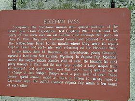
Sacagawea, the Shoshone woman who guided parts of the Lewis and Clark Expedition (the Corps of Discovery), led Captain William Clark and his party of ten men through the pass on July 15, 1806. They were eastward bound and planned to explore the Yellowstone River to its mouth, where they were to rejoin Captain Meriwether Lewis and party, who were returning eastward via the Missouri River.,