
- elevation 0 ft (0 m) | - elevation 0 ft (0 m) | |
 | ||
Similar Windy Run, Kingman Lake, Georgetown Reservoir, Pohick Creek, McMillan Reservoir | ||
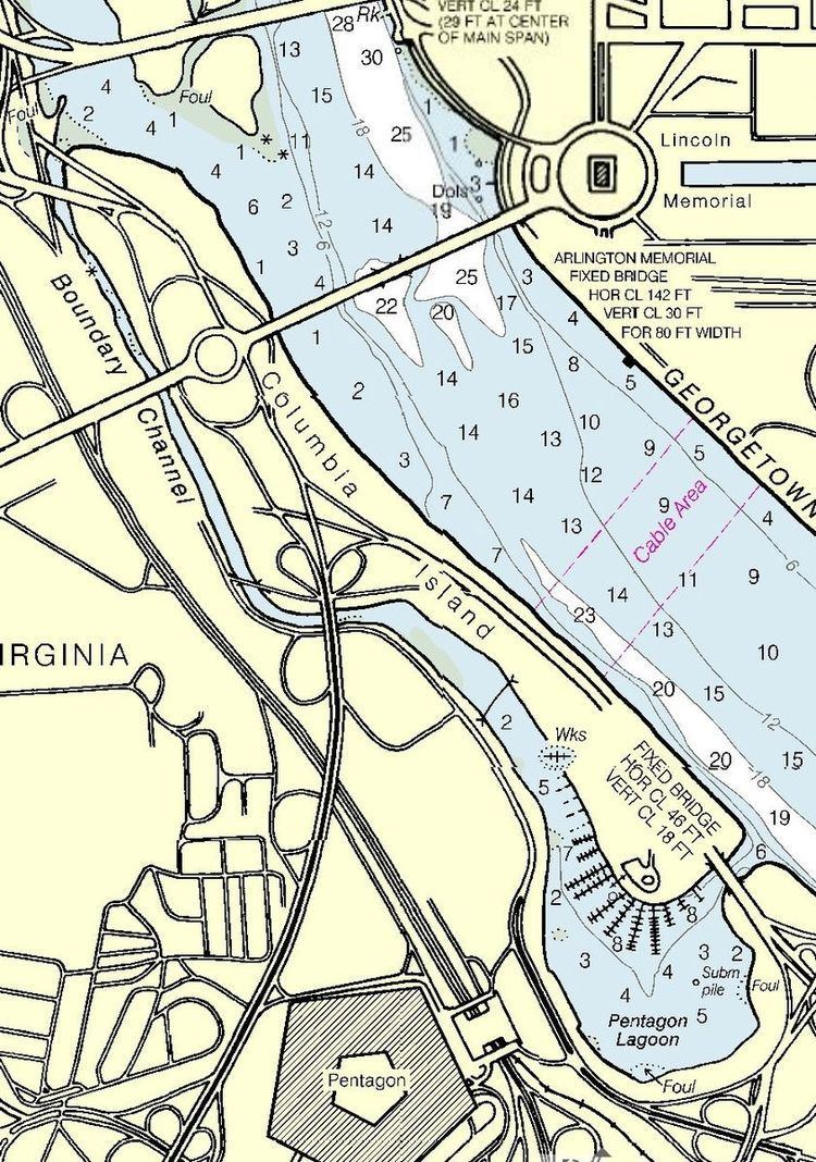
Boundary Channel is a channel off the Potomac River in Washington, D.C. The channel begins at the northwestern tip of Columbia Island extends southward between Columbia Island and the Virginia shoreline. It curves around the southern tip of Columbia Island before heading northeast to exit into the Potomac River. At the southwestern tip of Columbia Island, the Boundary Channel widens into the manmade Pentagon Lagoon.
Contents
Map of Boundary Channel, United States
History of Boundary ChannelEdit
Columbia Island is in part natural, and in part man-made. About 1818, Analostan Island (now known as Theodore Roosevelt Island) was largely rock and quite close to the D.C. shoreline. Due to deforestation and increased agricultural use upstream, the river eroded much of the northern bank of the Potomac River and widened the gap between Analostan Island and the shore. Simultaneously, large deposits of silt built up around Analostan Island. By 1838, Analostan had almost doubled in length toward the south. By 1884, the new southern part of Analostan Island was defined and built up, and supported a well-established wetland. Gradually, however, the river eroded the center of Analostan Island, severing Columbia Island from its parent body.
Between 1911 and 1922, the Potomac River was repeatedly dredged by the United States Army Corps of Engineers to deepen the channel and alleviate flooding. Dredging widened the distance between Analostan/Theodore Roosevelt Island and Columbia Island (so that the "Virginia Channel" west of Analostan/Roosevelt Island would not flood easily). Dredged material was piled high on Columbia Island, helping to build it higher, lengthen and broaden it, and give it its current shape. The new island received its name about 1918 from an unnamed engineer working for the District of Columbia.
An anonymous Corps of Engineers officer named the waterway between Columbia Island and Virginia the "Boundary Channel".
Boundary Channel was further defined in the late 1920s. In 1925, Congress authorized construction of the Arlington Memorial Bridge across the Potomac River. Preliminary designs for the bridge showed it terminating on Columbia Island, which necessitated additional expansion of the island. The Corps of Engineers had already planned to continue dredging the Potomac River and enlarge Columbia Island, so on April 1, 1925, Secretary of War John W. Weeks ordered the expenditure of $114,500 to dredge the river between the Highway Bridge and the Lincoln Memorial. The dredged material was dumped on Columbia Island. By June 30, 1927, dredging of the Potomac River and the reshaping of Columbia Island was largely finished.
Boundary Channel marks the original Virginia shoreline. It separates Columbia Island to the east from Virginia in the west and south, and is roughly a mile long. The channel is part of the Potomac River. In 1936, Boundary Channel was 100 to 200 feet (30 to 61 m) in width and 4 to 6 feet (1.2 to 1.8 m) in depth. No lagoon existed at this time.
Broundary Channel was changed again after ground was broken for The Pentagon on September 11, 1941. The Pentagon was being built on land just south of the Boundary Channel. But the ground to the northwest, north, northeast, and east of the building site was so low that, for a time, the Corps of Engineers considered building a levee to protect it from floods. But General Brehon B. Somervell, the Army officer in charge of the Pentagon's construction, decided instead to raise the ground by at least 8 feet (2.4 m) to 18 feet (5.5 m) or more above the average water level. Boundary Channel was dredged and slightly widened in order to help provide this fill material.
Due to silting and other issues, Boundary Channel is approximately 100 feet (30 m) wide as of 2013 (although the width varies). It is also quite shallow.
Pentagon LagoonEdit
Pentagon Lagoon is a shallow pool which is part of the Boundary Channel. It was originally constructed as part of the channel, and was originally quite small as well as unnamed.
During construction of the Pentagon in 1941, the U.S. Army not only needed a source of fill material to raise the land around the Pentagon, but also needed a way for river barges to deliver concrete, gravel, and sand to the construction site. With unused Columbia Island nearby, the Corps of Engineers quickly removed a portion of the island as well as dredged the bottom of the lagoon for this fill material. The Army also constructed a dike inland on the Virginia shoreline. The earth behind this dike was excavated to a depth 14 feet (4.3 m) below the Potomac River's average high tide. On what was to be the new shoreline, the Army and its contractors built cement plants and marshalling areas for the deposit of sand and gravel. The dike was then breached (and removed by dredge), allowing barges and other ships to deliver construction materials quickly and cheaply to the building site. More than 1,000,000 cubic yards (760,000 m3) of earth and riverbottom were excavated, and Boundary Channel's lagoon enlarged by 30 acres (120,000 m2).
The Pentagon Lagoon was named by the Washington Post after a brutal murder there in September 1944. Virginia police found the nude body of 53-year-old Mrs. Margaret Fitzwater floating in the lagoon on the evening of September 24, 1944. Her throat had been slashed, and she had been raped. Within days, 60-year-old Gardner Tyler "Pop" Holmes, an eccentric who lived on a houseboat anchored in the lagoon, was charged with her murder. It quickly became apparent that Holmes was insane (and had, in fact, escaped from a Virginia mental hospital in 1931). A second throat-slashing murder and rape occurred on Hains Point (almost directly east of Boundary Channel on the D.C. side of the Potomac River) on October 5. This victim was 18-year-old Dorothy Berrum. Investigators quickly found eyewitnesses and a chain of evidence which led them to United States Marine Corps Private Earl McFarland. McFarland was indicted on December 11, 1944, and a jury convicted him of murder after an hour's deliberation on February 1, 1945. He was sentenced to die in the electric chair. On April 3, McFarland and a companion escaped from the D.C. Jail. Two guards were playing cards with them, and the men overpowered them and walked out of the unlocked cell block. An eight-day manhunt covered the entire East Coast before McFarland was recaptured in Knoxville, Tennessee, (his home town) on April 11. His escape led to scathing indictments about the way the D.C. Jail was staffed and managed. President Harry S. Truman declined to give McFarland clemency on July 3, 1946, and the Supreme Court of the United States denied his appeal on July 18. He was executed on July 19.
The phrase "Pentagon lagoon" was first used by the federal government in 1945, but the formal name "Pentagon Lagoon" was not used until 1946.
When the Pentagon Lagoon was surveyed in 2000, the eastern entrance channel was 7.5 feet (2.3 m) deep. Depths of 5 to 8 feet (1.5 to 2.4 m) were common in front of the Columbia Island Marina, while 2 to 7 feet (0.61 to 2.13 m) was common elsewhere in the lagoon.