
Sovereign state United Kingdom Area rank 209th Area code 01282 | Constituent country England Area 110.6 km² | |
 | ||
Time zone Greenwich Mean Time (UTC+0) | ||
The Borough of Burnley (/ˈbɜːrnli/) is a local government district of Lancashire, England, with the status of a non-metropolitan district and borough. It has an area of 42.7 square miles (110.7 km2) and a population of 87,400 (mid-2015 est.), and is named after its largest town, Burnley. The borough is bounded by Hyndburn, Ribble Valley, Pendle, Rossendale – all in Lancashire – and the borough of Calderdale in West Yorkshire. It is governed by Burnley Borough Council, which has been controlled by the Liberal Democrats since 2008.
Contents
History
The current borders date from 1 April 1974, when the former county borough of Burnley merged with the urban district of Padiham and part of Burnley Rural District. In 2007 its proposal to merge with neighbouring Pendle Borough Council to form a larger unitary authority was rejected by the government.
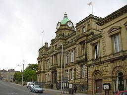
Governance
Burnley Borough Council has had a predominantly Labour controlled history, the party returned to power in 2012, after a period of leadership by the Liberal Democrats. The borough comprises 15 wards electing a total of 45 councillors.
Wards: Bank Hall, Briercliffe, Brunshaw, Coal Clough with Deerplay, Daneshouse with Stoneyholme, Gannow, Lanehead, Queensgate, Rosegrove with Lowerhouse, Rosehill with Burnley Wood, Trinity, and Whittlefield with Ightenhill, Cliviger with Worsthorne, Gawthorpe, and Hapton with Park.
The borough contains the civil parishes of Ightenhill, Habergham Eaves, Dunnockshaw and Clowbridge, Hapton, Cliviger, Briercliffe, and Worsthorne-with-Hurstwood.
Padiham Town Council was established in 2002.
Since 2002, a number of BNP councillors have been elected in the borough, with the last councilor losing her seat in the Hapton with Park ward in 2012.
Geography
Places in the borough of Burnley include:
Demography
The borough's population has fallen from a high of 130,339 in 1911 to an estimated 87,700 in 2005. Between 1991 and 2001, it fell by 2.6%. Its employment rate of 59.0% places it 261st out of 376 local authorities in England & Wales; just 12.6% of its workforce are graduates, placing it 325th out of 376 local authorities.
A 2010 report commissioned by the BBC and compiled by Experian ranked the borough as having the second lowest property prices in England, this combined with GCSE results and crime rates, led to the borough being ranked as the worst place in England.
Education
Education Services in the borough are provided and controlled by Lancashire County Council.
Health
Health services in the borough are provided by East Lancashire Primary Care Trust and East Lancashire Hospitals NHS Trust, with additional services provided by the North West Ambulance Service and North West Air Ambulance.
The Hospital Trust operates Burnley General Hospital, while the PCT operates the network of GP surgeries, and recently opened 2 Primary Health Care Centres in the borough (St. Peters Centre in 2006 and Briercliffe in 2007).
Policing
Policing Services in the borough are provided by the Pennine division of Lancashire Constabulary based at Burnley Police station, and controlled by Lancashire County Council. Plans are in place to merge the pennine division into the neighbouring eastern division, based in Blackburn. Policing Services of the borough's Railways are provided by North West division of the British Transport Police - the nearest Transport Police office being in Preston.
Fire and rescue
Fire and rescue services in the borough are provided by Lancashire Fire and Rescue Service and controlled by Lancashire County Council.
Waste and recycling
Refuse and recycling collection, and street cleansing is the responsibly of the borough council and these services are currently contracted to Veolia Environmental Services at a cost of approximately £3m / year. The borough Council has signed up to Lancashire's Municipal Waste Management Strategy, which specifies that the borough must recycle or compost 56% of all waste by 2015 and 61% by 2020.
There are currently 2 household waste recycling centres run by Lancashire County Council in the borough. One located on Grosvenor Street in Burnley and the second on Park Road in Padiham. Lancashire County Councils long term plans to replace the Burnley site with facility at Heasandford Industrial Estate on the north eastern edge of the town, where approved in 2010 despite local objections regarding the site’s suitability. 3 months later they then announced the closure of the Padiham site as part of cost-cutting measures, increasing the unsuitability of the new Burnley site’s location.