
OS grid reference SD875325 Sovereign state United Kingdom | Local time Thursday 5:55 AM | |
 | ||
Civil parish Worsthorne-with-Hurstwood Weather 3°C, Wind W at 6 km/h, 95% Humidity | ||
Worsthorne burnley 13 09 16 lightening storm
Worsthorne is a rural village on the eastern outskirts of Burnley in Lancashire, England. It is in the civil parish of Worsthorne-with-Hurstwood and the borough of Burnley. The village was known as Worthesthorn in 1202, which means "thorn tree of a man named 'Weorth'."
Contents
- Worsthorne burnley 13 09 16 lightening storm
- Map of Worsthorne Burnley UK
- History
- Governance
- Landmarks
- Education
- Transport
- Notable people
- References
Map of Worsthorne, Burnley, UK
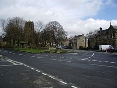
The village has a small village green, overlooked by the church and Bay Horse public house. Buildings in the village include cottages dating from the 16th and 17th centuries, and housing for millworkers dating from the Industrial Revolution. Relatively high property prices in the village reflect the fact that it is perceived to be a desirable place to live, with low crime and good education.
History
The history of human habitation in the area goes back to the late stone, bronze and Iron Ages. Earthworks and two prehistoric stone circles are shown on Ordnance Survey maps, one at grid reference SD885327 on the moors to the east of the village; both are in a poor state of repair. A flint dagger 15 cm in length found on the moor is now in Towneley Museum.
Governance
Worsthorne forms part of the Worsthorne with Cliviger ward, which is currently represented on Burnley Borough Council by three Conservative councillors. In 2002 the ward elected a British National Party (BNP) councillor, which generated considerable media comment at the time; the seat returned to the Conservative Party when it was next contested.
Landmarks
The village had a close association with the Thursby family, benefactors of the Burnley area, and has a number of listed buildings. These include Jackson's House in the centre of the village, which was built in about 1600, and the Church of St. John the Evangelist which dates from 1833-1839. The original plans for the church, drawn up by architect Lewis Vulliamy, can be seen on the Incorporated Church Building Society website. It has a 61 ft clocktower, stained glass windows and wrought ironwork. The churchyard has the grave of a packmaster, a person whose job was to lead packhorses across the moors in special sunken trails that allowed the horses to walk unhitched since the walls of the trail prevented them from straying.
An earlier landmark used to be Worsthorne Methodist Chapel, near Jackson's House, but it was demolished in the 1980s. The connected Sunday School building is now a home for old people.
There is a former cotton mill in Gordon Street, a relic of the time when the area, especially Burnley, was the world centre of cotton weaving.
There are two public houses in the village: the Crooked Billet and the Bay Horse Inn.
Education
The village has a primary school with about 180 pupils in the 4-11 age range, serving Worsthorne, Hurstwood, Brownside and Pike Hill. The school houses seven classes in modern buildings and has extensive playing fields and grounds. Students are organised into four houses, Gorple, Extwistle, Brownside and Ormerod. The houses are named after the four roads running into Worsthorne, which meet in the village square. The original village school house, now converted into residential housing, stands in the square.
Transport
A regular bus service (route 1) runs between Worsthorne, Burnley and Stoops.