
Car plates DBL | Area 1,303 km² | |
 | ||
Gminas Total 6 (incl. 1 urban)BolesławiecGmina BolesławiecGmina GromadkaGmina NowogrodziecGmina OsiecznicaGmina Warta Bolesławiecka Points of interest Kliczków Castle, Muzeum Ceramiki w Bolesławcu, Żywe Muzeum Ceramiki, Muzeum i Gród Średniow, Skansenik Tomisław Destinations Bolesławiec, Przemków Landscap, Kliczków, Nowogrodziec, Gościszów | ||
Bolesławiec County (Polish: powiat bolesławiecki) is a unit of territorial administration and local government (powiat) in Lower Silesian Voivodeship, southwestern Poland. It came into being on January 1, 1999, as a result of the Polish local government reforms passed in 1998. Its administrative seat is the town of Bolesławiec, famed for its pottery, and its only other town is Nowogrodziec. The county covers an area of 1,303.3 square kilometres (503.2 sq mi).
Contents
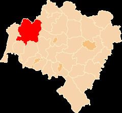
Map of Boles%C5%82awiec County, Poland
As at 2006 the total population of the county is 88,343, of which the population of Bolesławiec is 40,837, that of Nowogrodziec is 4,068, and the rural population is 43,451.
Neighbouring counties
Bolesławiec County is bordered by Żagań County to the north, Polkowice County to the north-east, Legnica County and Złotoryja County to the east, Lwówek Śląski County to the south, Lubań County to the south-west, and Zgorzelec County to the west.
Administrative division
The county is subdivided into six gminas (one urban, one urban-rural and four rural). These are listed in the following table, in descending order of population.