
- left Deer River - elevation 246 ft (75 m) Basin area 4,973 km² Country United States of America | - elevation 1,850 ft (564 m) Length 201 km | |
 | ||
Sources Little Black Creek, Adirondack Mountains, North Lake Similar Adirondack Mountains, Lake Ontario, Black River Canal, Salmon River, Oswego River | ||
The Black River is a 125-mile-long (201 km) blackwater river that empties into the eastern end of Lake Ontario on the shore of Jefferson County, New York in the United States. The origin of the name is not clear, but it may stem from the natural tannic acid that darkens the water in places. The river flows in a generally northwest direction, with its valley dividing the Adirondack Mountains on the east from the Tug Hill region to the west.
Contents
- Map of Black River Ohio NY USA
- CourseEdit
- DamsEdit
- Sporting activitiesEdit
- Environmental issuesEdit
- References
Map of Black River, Ohio, NY, USA
CourseEdit
The Black River originates at North Lake in the foothills of the Adirondacks, in Herkimer County, about 25 miles (40 km) east of Boonville. The river flows west into Oneida County then north, past Forestport and Boonville into Lewis County. At Lyons Falls, it is joined by the Moose River from the east just above the eponymous waterfall, where the river drops 70 feet (21 m) over a gneiss cliff.
Near Glenfield the Black River receives the smaller tributaries of Otter Creek and the Independence River, also from the east. Further north, it passes Lowville, then receives the Beaver River from the east, then the Deer River, its only major western tributary. Starting above Carthage the river briefly divides Lewis and Jefferson Counties before crossing entirely into Jefferson County, where it turns sharply west toward Lake Ontario, flowing past Great Bend, Black River and Watertown. Below Watertown it enters a canyon, well known for its challenging rapids.
The river ends at Lake Ontario in the village of Dexter, about 10 miles (16 km) west of Watertown, where it empties into the Black River Bay and Marsh, which are parts of the Golden Crescent. For the last few miles it forms the boundary between the Towns of Brownville and Hounsfield.
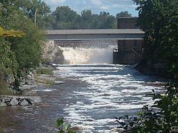
DamsEdit
There are at least 17 dams on the Black River, with eight in the upper part above Lyons Falls, and nine below Watertown. The upper and lower reaches of the river have a steep gradient and were originally developed to provide mechanical power for mills, such as the old Georgia-Pacific paper mill (which now sits abandoned and falling into disrepair) in Lyons Falls, and later hydroelectricity. In contrast the middle 40 miles (64 km) of the river have practically no gradient and are not suitable to the development of head for industrial or hydropower projects.
The three uppermost dams, forming North Lake, Kayuta Lake and the smaller Forestport Reservoir are the only structures forming significant impoundments. The other dams are run-of-the-river, with no appreciable storage capacity, so power generation is entirely dependent on the natural flow of the river combined with releases from upstream reservoirs, which is relatively consistent except for drought years.
Sporting activitiesEdit
The river is an excellent location for fishing. Abundant trout, salmon, bass, and pike are present in the stream, and salmon is the most favored.
Whitewater rafting and kayaking are popular on some stretches of the river, notably the Black River Canyon, which begins in Watertown and ends in Brownville. The Black River Canyon is one of few whitewater streams which have reliable flows throughout the summer. The "Canyon" itself is not actually present until you reach Brownville and ends in the Dexter Reservoir.
Environmental issuesEdit
A number of streams and lakes in the watershed have been impaired as a result of acid rain. Elevated levels of mercury have led to restrictions on the consumption of fish in some areas.
In August 2005, the Black River was contaminated by a spill from a manure lagoon on Marks Dairy Farm (a concentrated animal feeding operation near Lowville) when a retaining wall gave way, allowing the contents of a waste holding pond to spill. About 3 million US gallons (11,000 m3) of pollution flowed into the river. An estimated 280,000 to 375,000 fish were killed.
As of August 3, 2006 a settlement has been reached and Marks Dairy Farm, originator of the spill, was ordered to pay $2.2 million.