
Country United States ZIP codes 13634, 13657 Elevation 86 m Population 1,100 (2013) | State New York Time zone Eastern (EST) (UTC-5) FIPS code 36-20500 Local time Tuesday 4:24 PM Area code 315 | |
 | ||
Weather 11°C, Wind S at 23 km/h, 88% Humidity Area 129 ha (104 ha Land / 26 ha Water) | ||
Dexter is a village in Jefferson County, New York, United States. The population was 1,052 at the 2010 census. The name is derived from Simon Newton Dexter, one of the village's stockholders.
Contents
Map of Dexter, NY, USA
The Village of Dexter is in the south part of the Town of Brownville and is west of Watertown.
History
The village was formerly called "Fish Island," and was part of the lands belonging to Jacob and John Brown. The village was renamed "Dexter" after Simon Newton Dexter.
Dexter became an incorporated village in 1855, with population of about 528.
The Dexter Universalist Church was listed on the National Register of Historic Places in 2003.
Geography
Dexter is located at 44°00′30″N 76°02′43″W.
According to the United States Census Bureau, the village has a total area of 0.5 square miles (1.3 km2), of which, 0.4 square miles (1.0 km2) of it is land and 0.1 square miles (0.26 km2) of it (14.29%) is water.
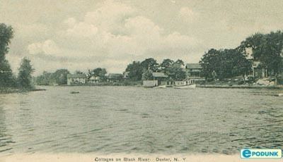
The village is adjacent to the Black River, near Black River Bay, an arm of Lake Ontario.
New York State Route 180, a north-south highway, passes through the village. County Roads 53 and 59 also service the community.
Demographics
As of the census of 2000, there were 1,120 people, 420 households, and 299 families residing in the village. The population density was 2,704.7 people per square mile (1,054.7/km2). There were 455 housing units at an average density of 1,098.8 per square mile (428.5/km2). The racial makeup of the village was 97.86% White, 0.27% African American, 0.27% Native American, 0.45% Asian, and 1.16% from two or more races. Hispanic or Latino of any race were 0.62% of the population.
There were 420 households out of which 37.4% had children under the age of 18 living with them, 48.6% were married couples living together, 17.9% had a female householder with no husband present, and 28.8% were non-families. 24.8% of all households were made up of individuals and 13.3% had someone living alone who was 65 years of age or older. The average household size was 2.62 and the average family size was 3.10.
In the village, the population was distributed with 28.8% under the age of 18, 8.5% from 18 to 24, 26.7% from 25 to 44, 20.5% from 45 to 64, and 15.4% who were 65 years of age or older. The median age was 36 years. For every 100 females there were 78.3 males. For every 100 females age 18 and over, there were 74.4 males.
The median income for a household in the village was $33,482, and the median income for a family was $40,000. Males had a median income of $36,875 versus $19,706 for females. The per capita income for the village was $17,138. About 14.2% of families and 14.1% of the population were below the poverty line, including 11.7% of those under age 18 and 24.1% of those age 65 or over.