Bidwell Park is a municipal park located in Chico, California. The park was established July 10, 1905, through the donation by Annie Bidwell (widow of Chico's founder, John Bidwell) of approximately 2,500 acres (10 km2) of land to the City of Chico. Since that time, the City has purchased additional land, such as Cedar Grove in 1922, and 1,200 acres (5 km2) of land south of Big Chico Creek in upper Bidwell Park in 1995. Today, the total Park size is 3,670 acres (15 km2), nearly 11 miles (18 km) in length, making it the third largest municipal park in California and one of the 25 largest city parks in the United States.
Bidwell Park is "divided" by Manzanita Avenue. The area west of Manzanita Avenue is referred to as Lower Park and the area to the east is referred to as Middle and Upper Park. Middle Park extends from Manzanita to a point roughly equal to the upstream edge of the Chico Municipal Golf Course. The noticeable difference between Upper/Middle and Lower Park is the terrain. Upper Park is located in the foothills of the southernmost Cascades. It has steep terrain and shallow soils, and contains many rock formations, including the unique Chico Formation sandstone and Lovejoy Basalt rocks. Lower Park is flat and level with a deep soil structure supporting a thick canopy of trees which provide ample shade for the visitor. Special rules also apply in the Upper Park and the road is unpaved for much of its length.
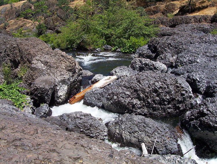
Sycamore Pool, located in the One Mile Recreation Area. The pool was constructed in the late 1920s and provides a unique swimming experience because its concrete decks, walls, and bottom are built to contain Big Chico Creek as it flows through the park. A dam and fish ladder at one end allow control of the creek's flow. The dam is raised and lifeguards are present from Memorial Day to Labor Day of each year. Above the fish ladder there is a bridge that separates the pool and the creek, from which many locals feed sucker fish in the bottom of the fish ladder. Locals often refer to Sycamore Pool simply as One Mile.Caper Acres playground is also located in the One Mile Recreation Area. Originally constructed in the 1950s, the playground provides a fairy tale-themed location for children to play in. Many play attractions in the playground were destroyed by a storm in 1995, but were rebuilt by members of the community. Adult visitors to the playground must be accompanied by a child 13 years of age or younger.Cedar Grove is home to the 2nd tree experimentation farm in the U.S. Trees from around the world were planted in the grove by John Bidwell in 1888.Five Mile, located near Manzanita Avenue in the upper park area, is a manicured park and picnic area. A flood control dam makes the water deep enough for swimming in the spring and summer. During times of high water, part of the flow of Big Chico Creek is diverted into the Diversion Channel which flows into Lindo Channel, on the north side of town.The Hooker Oak was a large Valley Oak which grew along Manzanita Avenue north of Big Chico Creek near the Five Mile recreation area. Investigation of the 'tree' upon its death revealed that it was actually two trees that had grown together.Horseshoe Lake, located in upper Bidwell Park, was constructed in the 1930s as a reservoir in which to irrigate the Bidwell Municipal Golf Course, located across Upper Park Road from the lake. The land around the lake was the site of several shooting ranges. One was used by the California National Guard and later, during World War II, the U.S. Army. A concrete bunker used for military target practice still remains next to the lake today. The other two ranges were used by civilians to shoot rifles and shotguns (skeet). All remnants of the shooting ranges (with exception of the military bunker) were removed in 2005 as part of a lead and skeet removal project. The lake is also the site of the annual "Hooked on Fishing, Not on Drugs" fishing derby for children.Monkey Face is a rock formation that was so named because it resembles a semi profile of a monkey head. It faces west over parking area E and Horseshoe Lake. The best place to start is from parking area E. As of Jan. 2013, major efforts are being made by the Park Dept. to mitigate erosion damage from multiple trails. Park users can respect the environment by using the trails designated.Alligator Hole is a shallow swimming hole in upper Bidwell Park near an area used by the Boy Scouts of America for campouts and other gatherings, between Horseshoe Lake and Bear Hole. Refrain from creating rock dams in the area, which are prevalent in the creek, but impede upon the movement of the salmon runs.Bear Hole, located in upper Bidwell Park beyond Horseshoe Lake, is a part of the creek that is frequently used for swimming and diving. The water is deep during the spring and summer and rocks on both sides are used for sunbathing. However, the currents in the area have a reputation for being dangerously unpredictable and have at times been fatal. In 1998 there were 4 drowning deaths within months. Bear Hole has a dirt and gravel parking area and a short trail.Diversion Dam, located just upstream from Bear Hole, is so named because it diverted some of the water from Big Chico Creek into a flume for use by the city. Remains of the flume can be seen along the banks of Big Chico Creek downstream of Bear Hole, and just upstream of Alligator Hole the flume track leaves the main creek channel and continues across the open area north of the creek.Salmon Hole, located in upper Bidwell Park beyond Bear Hole, is a part of the creek that is used for swimming. The site, which is essentially a large pond along the creek, is less accessible by car than Bear Hole and requires a short hike downward from the top of the rim. Visitors should come prepared to do some climbing. The salmon here have several hurdles to reach their native habitat. Refraining from building rock dams that span the creek is a good idea.Devil's Kitchen, North Rim, B Trail, Yahi Trail, Bidwell Municipal Golf Course.Chico Creek Nature Center, the park's official interpretive center, is a private non-profit nature center dedicated to enhancing the public's awareness of Bidwell Park. The center features non-releasable injured wildlife in the Janeece Webb Living Animal Museum and the Alice Heckert Native Plant Garden. The Center opened a new facility in spring of 2010, including the installation of new natural history exhibits in Howard S. Tucker Hall and a hands-on science classroom, Kristie's Nature Lab.
Programs offered include preschool-age workshops, nature-themed birthday parties, exploration-oriented day camps, and K-6 grade environmental education field trips, guided nature hikes, and nature education programs for all ages.
1918 20-acre (81,000 m2) fish hatchery proposed1920 (approx.) Golf course put in — 9 holes1921 Forestry Station land added to Lower Park. Now the site of Cedar Grove, the Nature Center, and World of Trees1921,1926 airfield near golf course proposed1925 First clubhouse built at golf course1926 Company G, 184th Infantry gets permission to construct rifle range1932 Polo field proposed1933 CCC winter camp building east of the golf course proposed1934 Kennedy tract (walnut orchard) added to north side of Lower Park1937 (and prior to) Horseshoe Lake reservoir in existence1937 Sections of The Adventures of Robin Hood, starring Errol Flynn and Olivia de Havilland, were filmed in Lower Park1939 Petersen Memorial Drive built by CCC1940 Overnight campground proposed in northeastern end of park1941 Military camping okayed1942–45 Diversion Dam built (year uncertain)1946 Archery area established by Glenn Archery Club1947 25-year lease and improvements on Radar bombing site proposed1949 Recreation District formed (CARD)1950 Softball field moved to Hooker Oak area1950 Water control dams on Chico Creek proposed1951 Day Camp established by CARD and Chico Teachers College1951 First mention of Easter Cross in BPPC minutes1953 CDF Fire Station with 1.6 acres (6500 m2) proposed NW of Live Oak Grove (30 yrs)1953 Horseback riding groups ask BPPC for arena site. Okayed, but no funds.1953 Area near One Mile Dam leased to CARD for Sycamore baseball field.1953 Chief Evans asks for site for Police pistol range1953–54 Pistol range under construction1954 Camp Fire Girls (now Camp Fire) dedicate Campfire Council Ring in Lower Park1955 Local midget race car group builds 250 ft (76 m) long track in Live Oak Grove1955 & 56 Bridge requested for private property access above Day Camp1956 New rifle range requested for sole use of the National Guard, lease for 10 yrs1957–58 CARD develops Hooker Oak area1958 $25,000 fish ladder built. Ten dams in 300 ft (90 m) barrier1958 Motorcycle club asks to further develop Live Oak Grove area1959 Dam on Chico Creek (upper park) proposed1963 PG&E claims it will cost $147,000 extra to bypass Bidwell Park with major power lines, plus $16,000/ year. BPPC votes 3-1 to put lines elsewhere1964 PG&E power lines through upper park under construction1965 Sycamore Bypass diversion channel built1968 Chico Riding Club puts up arena1970 Five Mile Dam Recreation Area dedication1970 Caper Acres playground built1971 Footbridge at golf course replaced after old one washed out by high waters in 19701972 Rod & Gun Club reports 77,300 targets used in 1971— possible cleanup of used skeet clay birds discussed1972 Extensive discussion and study of closing South Park Dr. to cars1972 Rifle range shade structures built1973 Upper Park to be closed from 11:30 p.m. to 30 minutes before sunrise to reduce vandalism1973 Trial period for dogs off leash in Lower and Upper Park starts1974 CARD proposes tennis court construction at Hooker Oak as part of renovation and improvement plan. BPPC opposed. City Council tentatively approves.1974 Park Commission votes to stop issuing wood-cutting permits for Bidwell Park1974 Park Commission discusses instituting a city tree ordinance1974 Park Commission meeting minutes mention using sheep for weed control in park1974 Upper Park Road to be closed during wet weather at discretion of Park Superintendent1975 Park Commission discusses fire hazard in Park due to undergrowth1975 Banning of off-road vehicles on North Rim Trail discussed but no action taken1976 Bird sanctuary proposed for Lower Park by deer pen1976 Park Commission votes to close pistol range within 6 months1977 Bidwell Park site (by Mangrove Ave) proposed for new city/county library1979 Roller skating to be allowed in Lower Park1979 Request to fly remote control planes in Horseshoe Lake area including creation of a takeoff/landing area1979 North Rim road to be closed to vehicles in the winter months1980 20-station Par Course approved for Lower Park1981 Upper Park controlled burns start, with 1/5 of area to be burned each year1981 Commission Minutes note that there is only one trash can in Upper Park, users are supposed to "Pack it out"1982 Horse-drawn carriage tours proposed for Lower Park1983 Golf Course leased to private concessionaire with Park Commission relinquishing control over golf course management1983 Bocce ball courts proposed for Hooker Oak area1983 1300 acorns planted along Upper Park Road on north side1983 State Route 99 mural approved1983 Job title for Bidwell Park's two Community Service Officers is changed to Park Ranger1984 Park Department hires their first Urban Forester1984 Upper Park annual controlled burns stopped1985 Lost Park area surveyed and encroachments noted on maps1985 Tree nursery started in 1.2-acre (4900 m2) Lower Park walnut orchard area1986 North Park Dr. to become one-way westbound, open 11 a.m.-11 p.m.1987 Extensive discussion regarding use of park for military training1987 Discussion begins regarding feral cats in park1989 Rod and Gun Club's rifle and trap shooting ranges close1989 Golf course expanded and Upper Park Road realigned1989 Unauthorized disc golf courses begin to develop on 40-acre (160,000 m2) Hwy 32 site.1990 Shakespeare in the Park begins (D-Rock Is Born)1990 Bidwell Park Master Management Plan (MMP) approved by City Council.1992 1.5-mile (2.4 km) "B" Trail built by volunteers from east end of Rim Trail to Middle Trail1992 0.4-mile (600 m) Canyon Oak Trail (later renamed Maidu) built by volunteers from Middle Trail near Parking Area E to Rim Trail.1992 Realignment of Upper Park Road and Golf Course using Mitigated Negative Declaration.1991 Bidwell Park Wildfire Management Plan.1994 Chico General Plan approved. Bidwell Park, designated as a Resource Conservation Area (pg. 7-11).1993 Purchase of 40-acre (160,000 m2) BLM site on Hwy 321995 Acquisition of 1417 acres (5.73 km2) on south side of Big Chico Creek.1998–1999 Bloody Pin Trail rerouted and Guardians & Pine Trails built.1998 Park Commission votes to 'Declare its intent to consider a proposal to allow disc golf to remain on the existing hwy.32 site"1998 Annie Bidwell Trail proposed, to extend from Bidwell Mansion to end of Upper Park "within sight and sound of the creek".1999 1500-acre (6.1 km2) backfire covers north side of Upper Park between road and park boundary..1999 Bidwell Park Trails Manual approved, described as a "work in progress".2000–2001 1.25 miles (2 km) of Yahi Trail relocated and/or rebuilt.2001 Observatory built.2002 Horseshoe Lake Fishing Pier built.2002 GPS mapping of existing park trails and roads shows 40+ miles (60 km) of official and frequently used unofficial trails and road on the north side and 28 miles (45 km) on the south side.2000–2002 Trail plan developed with 23 "Focus Areas", includes new creekside ABT pedestrian trail segments on the south side, new 1-mile (1.6 km) segment of South Rim trail, new trail from the North Rim Trail starting at the power lines to Bear Hole, a new trail from the eastern end of Lower Trail to Bear Hole, a new trail from the Middle Trail to the potential Day Camp area bridge site, a new trail from the junction of the B Trail and Middle Trail to Parking Area U at the end of the road, reroute of east end of Upper Trail and several reroutes of Yahi Trail between Bear Hole and Parking Area P.2002 Bridges proposed above Day Camp and at the end of Upper Park Road2003 19-acre (77,000 m2) antimony, lead, copper and polycyclic aromatic hydrocarbons removal project planned for Horseshoe Lake and lead removal at former pistol range.2003 Conceptual approval of observatory outdoor seating area & spotting pads, including realignment of the road to Parking Area C.2003 Funding for update of Bidwell Park Master Management Plan and associated EIR approved by City Council.2003 Conceptual approval of horse workout pen by Horse Arena.