
Intercommunality Pays Saint-Pourcinois Area 8.08 km² Arrondissement Moulins | Population (2013) 133 Local time Thursday 9:32 AM | |
 | ||
Weather 8°C, Wind S at 5 km/h, 86% Humidity | ||
Barberier is a French commune in the Allier department in the Auvergne-Rhône-Alpes region of central France.
Contents
- Map of 03140 Barberier France
- Geography
- Mapping
- History
- Administration
- Demography
- Sites and monuments
- References
Map of 03140 Barberier, France
Geography
Barberier is located some 17 km (11 mi) north-west of Vichy and some 17 km (11 mi) north by north-east of Gannat. Access to the commune is by the D36 road from Étroussat in the west which passes through the centre of the commune and the village and continues east to join the D2009 east of the commune. The D183 comes from Bayet in the north and also passes through the centre of the commune, intersecting the D36 at the village, continuing south to join the D66 south of the commune. Apart from the village there are the hamlets of Les Varennes in the south, La Grange Neuve in the east, and Bompré in the north.
The Sioule river flows north along the south-eastern border of the commune and continues north to join the Allier north-east of Contigny.
Mapping
A list of online mapping systems can be displayed by clicking on the coordinates (latitude and longitude) in the top right hand corner of this article. None of these maps, however, show the extent of nor any information on the commune.
History
Barberier appears as Barbrier on the 1750 Cassini Map and the same the 1790 version.
Administration
List of Successive Mayors
(Not all data is known)
Demography
In 2013 the commune had 133 inhabitants. The evolution of the number of inhabitants is known from the population censuses conducted in the commune since 1793. From the 21st century, a census of communes with fewer than 10,000 inhabitants is held every five years, unlike larger communes that have a sample survey every year.
Sources : Ldh/EHESS/Cassini until 1962, INSEE database from 1968 (population without double counting and municipal population from 2006)
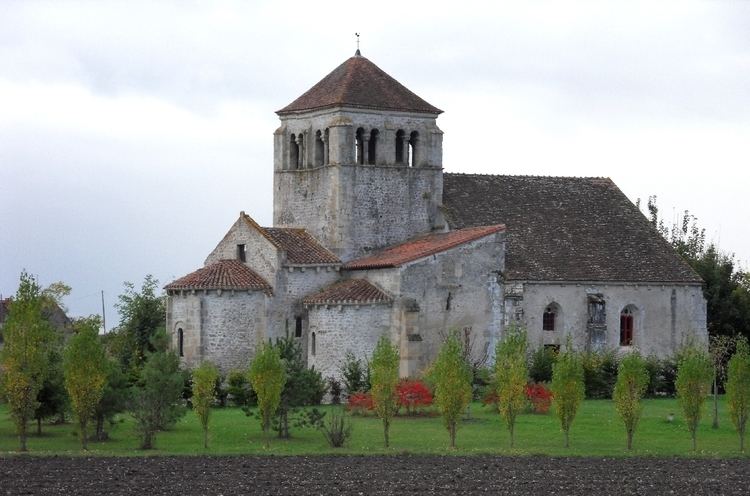
Sites and monuments
There are two sites in the commune that are registered as historical monuments: