
Area 27,768 km2 | ||
 | ||
Country Peoples Republic of China | ||
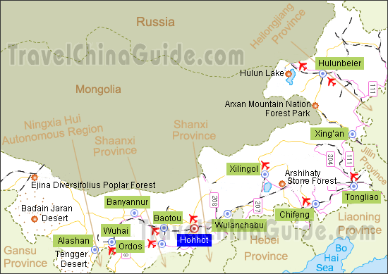
Map of Baotou
Baotou (Mongolian: ᠪᠤᠭᠤᠲᠤ ᠬᠣᠲᠠ Buɣutu qota, Бугат хот; Chinese: 包头市; pinyin: bāotóu) also known as Bugthot is the largest industrial city in the Inner Mongolia Autonomous Region of northern China. Governed as a prefecture-level city, its built-up (or metro) area made up of 5 urban districts is home to 2,070,801 inhabitants with a total population of over 2.65 million accounting for counties under its jurisdiction. The city's Mongolian name means "place with deer", and an alternate name is "Lucheng" (鹿城; Lùchéng), meaning "Deer City". The 39,000 capacity Baotou Olympic Sports Centre Stadium is the main sports venue in the city and is used mostly for football matches.
Contents
- Map of Baotou
- Baotou china 4k panorama by toby smith
- Taste of china pear and mikas a finer taste
- Administrative divisions
- History
- Geography and climate
- Economy
- Demographics
- Transportation
- References
Baotou china 4k panorama by toby smith
Taste of china pear and mikas a finer taste
Administrative divisions
Baotou is divided into 10 county-level divisions, including 7 districts, 1 county and 2 banners.
History
The area now known as Baotou was inhabited since ancient times by nomads, most notably the Mongols. Near the end of the Han Dynasty, Lü Bu, a particularly noteworthy warrior, was born in today's Jiuyuan District of Baotou. Compared to the capital of Inner Mongolia, Hohhot, Baotou's construction as a city came relatively late, being incorporated as a town in 1809. The city's site was chosen because it was in an arable region of the Yellow River's Great Bend.
The Gelaohui secret society and the Hui Muslim General Ma Fuxiang came to an agreement in 1922, in which Ma Fuxiang agreed to allow the Gelaohui to extort protection money from wool merchants in Baotou.
A railway from Beijing was constructed in 1923, and the city began spurring some industrial sites. A German-Chinese joint-venture in 1934 constructed the Baotou Airport and opened a weekly route connecting Baotou with Ningxia and Lanzhou.
When young Owen Lattimore visited Baotou in 1925, it was still "a little husk of a town in a great hollow shell of mud ramparts, where two busy streets made a traders' quarter", but already an important railhead. Qinghai and Gansu wool and hides were brought down the Yellow River by raft and boat from Lanzhou to Baotou, and shipped from Baotou by rail to the east (in particular, to Tianjin for export). The river traffic was one-way only, however, as the fast current made sailing up the Yellow River impractical. To travel from Baotou back to Lanzhou or Yinchuan, one would use a cart and camel road. There were also caravan roads from Baotou to Ordos and the Alxa League.
On September 19, 1949, after the September 19 Rebellion, Baotou fell under Communist control. The People's Government was formed in February 1950. In the early Communist years Baotou served as an industrial centre, with a significant portion of its economy coming from its steel production. The Iron and Steel Base in Baotou is one of the "156 projects", which were constructed with the help of Soviet Union to develop China's national economy in the 1950s and 1960s, and it continues this reputation until this day.
Geography and climate
Baotou is located in the west of Inner Mongolia, located at the junction of two economic zones: the Bohai Economic Rim and the Upper Yellow River Natural Resources Enrichment Zone (黄河上游资源富集区). Its administrative area borders Mongolia to the north, while the Yellow River, which flows for 214 kilometres (133 mi) in the prefecture, is south of the urban area itself. The Tumochuan Plateau (土默川平原), Hetao Plateau, and Yin Mountains cross the urban area and central part of the prefecture. Baotou City ranges in latitude from 41° 20' to 42° 40' N and in longitude from 109° 50' to 111° 25' E.
Baotou features a cold semi-arid climate (Köppen BSk), marked by long, cold and very dry winters, hot, somewhat humid summers, and strong winds, especially in spring. Temperatures often fall below −15 °C (5 °F) in winter and rise above 30 °C (86 °F) in summer. The annual precipitation is approximately 300 millimetres (11.8 in), with more than half of it falling in July and August alone. Due to the aridity and elevation, temperature differences between day and night can be large, especially in spring. In 2002, there were 12 instances of dust storms.
Economy
Baotou is the largest economy of the Inner Mongolia Autonomous Region, with a GDP value of 340.95 billion RMB in 2012, representing a 12.6% rise over the previous year, accounting for approximately 21.3% of the province's total.
Baotou Xingsheng Economic & Technological Development Zone is an industrial zone in Baotou. The mines in Bayan Obo are the greatest source of rare-earth metals globally. In 2005, they accounted for 45% of the total production on earth.
Demographics
Ethnic groups in Baotou, 2000 census.