
Vehicle registration CG Population 19,529 (2011) | Time zone IST (UTC+5:30) Elevation 360 m Local time Tuesday 2:14 PM | |
 | ||
Weather 33°C, Wind N at 10 km/h, 15% Humidity Neighborhoods Fulwari Para, Shanti Nagar, Irrigation Colony, Purana Thanapara | ||
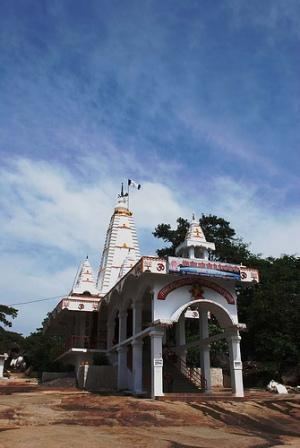
Chandimandir bagbahara me bhalu
Bagbahara is a city and a Municipality in Mahasamund district in the state of Chhattisgarh, India.
Contents
- Chandimandir bagbahara me bhalu
- Map of Bagbahara Chhattisgarh 493449
- Geography
- Demographics
- Economy
- Transport
- Nearby airports
- Culture
- References
Map of Bagbahara, Chhattisgarh 493449
Geography
Bagbahara is located at 21.03°N 82.38°E / 21.03; 82.38. It has an average elevation of 360 m (1,180 ft).
Demographics
As of 2001 India census, Bagbahara, located 90 kilometres east of Raipur had a population of 16,746. Males constitute 50% of the population and females 50%. Bagbahara has an average literacy rate of 59%, lower than the national average of 59.5%; with 59% of the males and 41% of females literate. 15% of the population is under 6 years of age.
Economy
Most of the population in the town are involved in farming. There are many rice mills in Bagbahara. In the other side the small & large scale factories are also situated in this town which gives an employment to the poor & unemployed peoples. The Town has a good market as well as all types of shops.
Transport
The town is connected to rest of the country by state highway and rail route. It falls on the Raipur Mahasamund Visakhapatnam route when travelling by train. Bus service is available frequently for Mahasamund. Direct buses for Raipur, Orissa are available for a specific time table.
Nearby airports
Culture
The town is also famous for the temple at Chandi Dongri. Thousands of devotees from the adjacent area to visit the temple in Navratri.The town is also known for wild bears who visit the temple daily during arti (prayer) and bows in front of goddess.