
Elevation 4,843 ft (1,476 m) Country United States Topo map USGS Cass | Peak Bald Knob | |
 | ||
Similar Allegheny Mountains, Shavers Mountain, Gaudineer Knob, Bickle Knob, Middle Mountain Cabins | ||
Back allegheny mountain
Back Allegheny Mountain is a long mountain ridge in eastern West Virginia. It is part of the Shavers Fork Mountain Complex in the Allegheny Range of the Appalachians.
Contents
- Back allegheny mountain
- Map of Back Allegheny Mountain Greenbank WV 26264 USA
- GeographyEdit
- Preservation and recreationEdit
- References
Map of Back Allegheny Mountain, Greenbank, WV 26264, USA
GeographyEdit
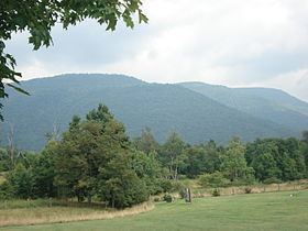
Back Allegheny Mountain runs 18 miles (29 km) north to south and 8 miles (13 km) east to west, covering a geographic area of 76 square miles (200 km2). The mountain rises abruptly from the Greenbrier River valley in Pocahontas County, West Virginia, and runs nearly parallel to Cheat Mountain to its west. The mountain reaches its elevational climax of 4,843 feet (1,476 m) at Bald Knob, 5 miles (8.0 km) north of Snowshoe Ski Resort. The second highest point on the mountain is Hosterman Benchmark West at 4,757 feet (1,450 m). Hosterman is approximately 3.3 miles (5.3 km) north of Bald Knob.
North of U.S. Route 250 west of Durbin, the same structural fold of the Earth's crust that forms Back Allegheny Mountain continues north as Shavers Mountain for an additional 35 miles (56 km).
Preservation and recreationEdit
Almost the entirety of Back Allegheny Mountain is protected by the Monongahela National Forest. The summit of Bald Knob is owned by the West Virginia Division of Natural Resources. Back Allegheny and other mountains in the area are known for their extensive red spruce forests, as well as other high altitude plants and animals. The whole of Back Allegheny is an environmentally sensitive area.
Bald Knob is the terminus of the 11-mile (18 km) long Cass Scenic Railroad State Park. The railroad carries visitors to an elevation of 4,730 feet (1,440 m) approximately 0.25 miles (0.40 km) north of the summit ridge. An overlook platform gives visitors a view of the Greenbrier Valley and, on clear days, a view all the way into Virginia 12 miles (19 km) away.
Snowshoe Mountain Ski Resort is situated in the bowl-shaped convergence of Back Allegheny with Cheat Mountain at the head of Shavers Fork. This area is essentially the southern terminus of both mountains.